
Navigation is a field of study that focuses on the process of monitoring and controlling the movement of a craft or vehicle from one place to another. The field of navigation includes four general categories: land navigation, marine navigation, aeronautic navigation, and space navigation.
Semi-automatic command to line of sight (SACLOS) is a method of missile command guidance. In SACLOS, the operator must continually point a sighting device at the target while the missile is in flight. Electronics in the sighting device and/or the missile then guide it to the target.

A non-directional beacon (NDB) or non-directional radio beacon is a radio beacon which does not include inherent directional information. Radio beacons are radio transmitters at a known location, used as an aviation or marine navigational aid. NDB are in contrast to directional radio beacons and other navigational aids, such as low-frequency radio range, VHF omnidirectional range (VOR) and tactical air navigation system (TACAN).
Automatic vehicle location is a means for automatically determining and transmitting the geographic location of a vehicle. This vehicle location data, from one or more vehicles, may then be collected by a vehicle tracking system to manage an overview of vehicle travel. As of 2017, GPS technology has reached the point of having the transmitting device be smaller than the size of a human thumb, able to run 6 months or more between battery charges, easy to communicate with smartphones — all for less than $20 USD.

A cell site, cell phone tower, cell base tower, or cellular base station is a cellular-enabled mobile device site where antennas and electronic communications equipment are placed to create a cell, or adjacent cells, in a cellular network. The raised structure typically supports antenna and one or more sets of transmitter/receivers transceivers, digital signal processors, control electronics, a GPS receiver for timing, primary and backup electrical power sources, and sheltering.

Direction finding (DF), or radio direction finding (RDF), is the use of radio waves to determine the direction to a radio source. The source may be a cooperating radio transmitter or may be an inadvertant source, a naturally-occurring radio source, or an illicit or enemy system. Radio direction finding differs from radar in that only the direction is determined by any one receiver; a radar system usually also gives a distance to the object of interest, as well as direction. By triangulation, the location of a radio source can be determined by measuring its direction from two or more locations. Radio direction finding is used in radio navigation for ships and aircraft, to locate emergency transmitters for search and rescue, for tracking wildlife, and to locate illegal or interfering transmitters. During the Second World War, radio direction finding was used by both sides to locate and direct aircraft, surface ships, and submarines.
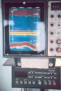
A fishfinder or sounder (Australia) is an instrument used to locate fish underwater by detecting reflected pulses of sound energy, as in sonar. A modern fishfinder displays measurements of reflected sound on a graphical display, allowing an operator to interpret information to locate schools of fish, underwater debris, and the bottom of a body of water. Fishfinder instruments are used both by sport and commercial fishermen. Modern electronics allow a high degree of integration between the fishfinder system, marine radar, compass and GPS navigation systems.

Conical scanning is a system used in early radar units to improve their accuracy, as well as making it easier to steer the antenna properly to point at a target. Conical scanning is similar in concept to the earlier lobe switching concept used on some of the earliest radars, and many examples of lobe switching sets were modified in the field to conical scanning during World War II, notably the German Würzburg radar. Antenna guidance can be made entirely automatic, as in the American SCR-584. Potential failure modes and susceptibility to deception jamming led to the replacement of conical scan systems with monopulse radar sets. They are still used by the Deep Space Network for maintaining communications links to space probes. The spin-stabilized Pioneer 10 and Pioneer 11 probes used onboard conical scanning maneuvers to track Earth in its orbit.
Traffic signal preemption is a system that allows an operator to override the normal operation of traffic lights. The most common use of these systems manipulates traffic signals in the path of an emergency vehicle, halting conflicting traffic and allowing the emergency vehicle right-of-way, thereby reducing response times and enhancing traffic safety. Signal preemption can also be used on tram, light-rail and bus rapid transit systems, to allow public transportation priority access through intersections, and by railroad systems at crossings to prevent collisions.

Canoe diving and Kayak diving are recreational diving where the divers paddle to a diving site in a canoe or kayak carrying all their gear in or on the boat to the place they want to dive. Canoe or kayak diving gives the diver independence from dive boat operators, while allowing dives at sites which are too far to comfortably swim, but are sufficiently sheltered.

Animal migration tracking is used in wildlife biology, conservation biology, ecology, and wildlife management to study animals' behavior in the wild. One of the first techniques was bird banding, placing passive ID tags on birds legs, to identify the bird in a future catch-and-release. Radio tracking involves attaching a small radio transmitter to the animal and following the signal with a RDF receiver. Sophisticated modern techniques use satellites to track tagged animals, and GPS tags which keep a log of the animal's location. With the Emergence of IoT the ability to make devices specific to the species or what is to be tracked is possible. One of the many goals of animal migration research has been to determine where the animals are going; however, researchers also want to know why they are going "there". Researchers not only look at the animals' migration but also what is between the migration endpoints to determine if a species is moving to new locations based on food density, a change in water temperature, or other stimulus, and the animal's ability to adapt to these changes. Migration tracking is a vital tool in efforts to control the impact of human civilization on populations of wild animals, and prevent or mitigate the ongoing extinction of endangered species.

BMW Assist is a telematic roadside assistance service offered by BMW. BMW Assist is similar to GM's OnStar or Mercedes-Benz mbrace services as they both use the cellular network and Global Positioning telemetry to locate or guide the vehicle. BMW Assist can provide turn-by-turn directions, remote unlocking, vehicle diagnostics, airbag deployment notification, theft recovery and towing or flat tire repair. The service is included free in most new BMWs. After expiration, it can be purchased at a yearly rate. As of March, 2016, BMW assist is undergoing a "technology upgrade" in the US, and renewals are not being processed for MY2013 and older models. BMW has provided no estimated time for completion. Those whose memberships have expired no longer have the advantages of the Safety or Convenience plans. Members who have active service as of December 31, 2016 will have a choice to receive $200 compensation for losing service or to receive a hardware retrofit to continue service. There is a population for whom BMW did not allow renewal between March and December 2016, thus forcing them out of safety and security features.
Global Navigation Satellite System (GNSS) receivers, using the GPS, GLONASS, Galileo or BeiDou system, are used in many applications. The first systems were developed in the 20th century, mainly to help military personnel find their way, but location awareness soon found many civilian applications.
Astrionics is the science and technology of the development and application of electronic systems, subsystems, and components used in spacecraft. The electronic systems on-board a spacecraft are embedded systems and include attitude determination and control, communications, command and telemetry, and computer systems. Sensors refers to the electronic components on board a spacecraft.
ENOS stands for "Elektronisches Notruf- und Ortungssystem" – "Electronic Rescue and Location System" - a system developed in Germany for use by divers at sea. ENOS allows people in distress to signal their location when drifting on the ocean's surface so they can be quickly located and rescued. Although the system was especially developed for scuba diving it can also be used for other water sports like windsurfing, jet skiing, sailing and boating.
The Ricoh 500SE digital compact camera is suitable for outdoor photography and networkability. Capability includes external information such as GPS position or barcode numbers within the image headers. External vendors sell hardware and software for workflows involving GPS positioning or barcode scanning. Most NMEA compliant Bluetooth GPS receivers can be used with this camera through its built in Bluetooth communication capability. The body is resistant to dust and water, making it robust for many environments.
GPS when applied in the earthmoving industry can be a viable asset to contractors and increase the overall efficiency of the job. Since GPS satellite positioning information is free to the public, it allows for everyone to take advantage of its uses. Heavy equipment manufacturers, in conjunction with GPS guidance system manufacturers, have been co-developing GPS guidance systems for heavy equipment since the late 1990s. These systems allow the equipment operator to use GPS position data to make decisions based on actual grade and design features. Some heavy equipment guidance systems can even operate the machine's implements automatically from a set design that was created for the particular jobsite. GPS guidance systems can have tolerances as small as two to three centimeters making them extremely accurate compared to relying on the operator's skill level. Since the machine's GPS system has the ability to know when it is off the design grade, this can reduce surveying and material costs required for a specific job.

An inertial measurement unit (IMU) is an electronic device that measures and reports a body's specific force, angular rate, and sometimes the orientation of the body, using a combination of accelerometers, gyroscopes, and sometimes magnetometers. When the magnetometer is included, IMUs are referred to as IMMUs.
RACELOGIC Ltd is a technology company based in Buckingham, United Kingdom.
Direction determination refers to the ways in which a cardinal direction or compass point can be determined in navigation and wayfinding. The most direct method is using a compass, but indirect methods exist, based on the Sun path, the stars, and satellite navigation.