
The Douro is the largest river of the Iberian Peninsula by discharge. It rises near Duruelo de la Sierra in the Spanish province of Soria, meanders briefly south, then flows generally west through the northern part of the Meseta Central in Castile and León into northern Portugal. Its largest tributary is the right-bank Esla. The Douro flows into the Atlantic Ocean at Porto, the second largest city of Portugal.
Miranda do Douro is a city and a municipality in the district of Bragança, northeastern Portugal. The population in 2011 was 7,482, in an area of 487.18 km2. The town proper had a population of 1,960 in 2001. Referred to as the "Cidade Museu" of the Trás-os-Montes region, it is located 86 kilometres from Bragança, preserving many of its medieval and Renaissance-era traditions and architecture. It has a language of its own, Mirandese, which enjoys official status in Portugal, in addition to cultural and historical discontinuity with the rest of the Portuguese state. The town is located on the border with Spain, with the Douro River separating the two countries. The nearest town in Spain is Zamora.

Trás-os-Montes e Alto Douro is a historical province of Portugal located in the northeastern corner of the country, known for its scenery, which includes plateaux, river valleys, mountains, and castles.

The GR footpaths are a network of long-distance walking trails in Europe, mostly in France, Belgium, the Netherlands, and Spain. They go by the following names: French: sentier de grande randonnée, West Flemish: Groteroutepad, Dutch: Langeafstandwandelpad, Spanish: sendero de gran recorrido, Portuguese: percurso pedestre de grande rota – generally meaning "long trail" or more literally "great route". The trails in France alone cover approximately 60,000 kilometres (37,000 mi). Trails are blazed with characteristic marks consisting of a white stripe above a red stripe. These appear regularly along the route, especially at places such as forks or crossroads.
Vila Nova de Gaia, or simply Gaia, is a city and a municipality in Porto District in Norte Region, Portugal. It is located south of the city of Porto on the other side of the Douro River. The city proper had a population of 178,255 in 2001. The municipality has an area of 168.46 square kilometres (65.04 sq mi) and a population of 303,824 inhabitants in 2021, making it the most populous municipality in Norte Region, and the third most populous in the country, after Lisbon and Sintra. Gaia along with Porto and 16 other municipalities make up the Porto metropolitan area.
Soutelo may refer to the following places in Portugal:
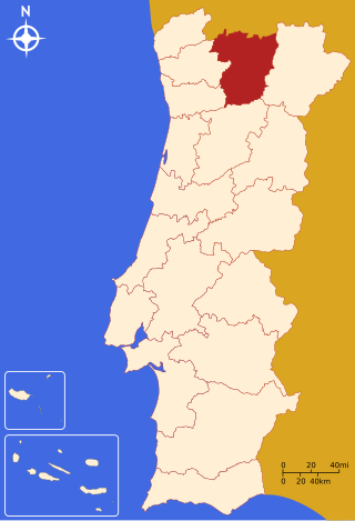
The District of Vila Real is a district of northern Portugal. With an area of 4,239 km2 (1,637 sq mi), the district is located east of the port city of Porto and north of the Douro River. Vila Real has always belonged to the historical province of Trás-os-Montes. Approximate population in the 2001 census was 230,000. The population has shown negative rates in recent years due to emigration and aging. Many of the villages have lost population and have become deserted while the district capital has gained in population. It is bordered by Spain (Galicia) in the north and east, Braga District and Porto District in the west, Viseu District in the south and Bragança District in the east.

Marco de Canaveses is a city and municipality on Porto district, in northern Portugal. The population in 2011 was 53,450, in an area of 201.89 km2. The city itself had a population of 9,042 in 2001.

Alijó is a municipality in the Norte Region of Portugal, located in the district of Vila Real. The population in 2021 was 10,486, in an area of 297.60 km2.

Carrazeda de Ansiães is a municipality in the district of Bragança in northern Portugal. The population in 2011 was 6,373, in an area of 279.24 km2.

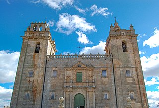
São João da Pesqueira is a municipality and municipal seat in the Portuguese district of Viseu. The population of the municipality in 2011 was approximately 7,874 inhabitants, in an area that extends 266.11 square kilometres (102.75 sq mi). The present mayor is Manuel Cordeiro, elected by a citizens' movement. The municipal holiday is June 24.

Amarante is a municipality and municipal seat in the Tâmega e Sousa subregion in northern Portugal. The population in 2011 was 56,264, in an area of 301.33 square kilometres (116.34 sq mi). The city itself had a population of 11,261 in 2001. The city has been part of the UNESCO Creative Cities Network under the category of City of Music since 2017.
Linha do Norte is the Portuguese main railway line that connects the two main Portuguese cities, Lisbon and Porto. Its length is 336.079 kilometres (208.830 mi). It goes through some other important cities such as Vila Franca de Xira, Santarém, Entroncamento, Pombal, Coimbra, Aveiro, Espinho and Vila Nova de Gaia. It constitutes the backbone of the Portuguese railway system of freight and passenger services, running approximately 720 trains daily.

The term "provinces" has been used throughout history to identify regions of continental Portugal. Current legal subdivisions of Portugal do not coincide with the provinces, but several provinces, in their 19th- and 20th-century versions, still correspond to culturally relevant, strongly self-identifying categories. They include:
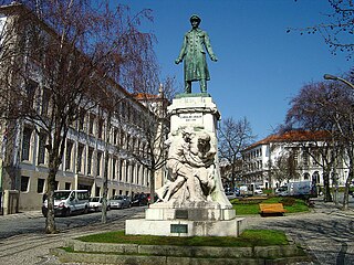
Vila Real is the capital and largest city of the Vila Real District, in the North region, Portugal. It is also the seat of the Douro intermunicipal community and of the Trás-os-Montes e Alto Douro historical province. The Vila Real municipality covers an area of 378.80 square kilometres (146.26 sq mi) and is home to an estimated population of 49,574 (2021), of which about 30,000 live in the urban area (2021).
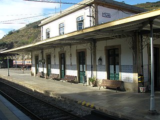
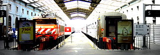
The Tua Railway Station is a railway station located in the civil parish of Castanheiro do Norte e Ribalonga, in the municipality of Carrazeda de Ansiães, close to the confluence of the Douro River and the Tua River. The station is served by Comboios de Portugal (CP) main line trains on the Douro line to/from Porto.
Trevões is a village and a civil parish (freguesia) in the municipality of São João da Pesqueira in the Viseu of Portugal. It is located approximately 8 km SSW of the town of São João da Pesqueira. Although small in size, the village possesses a church with some notable frescoes, and two museums, one devoted to artefacts of the village and surrounding countryside, and the other to religious art; there are also many ancient houses in its historic centre. The philosopher José Maria da Cunha Seixas was born in the village.
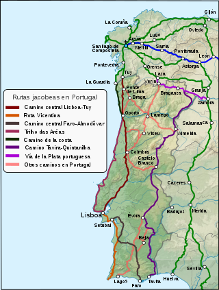
The Portuguese Way is the name of the Camino de Santiago pilgrimage routes starting in Portugal. It begins at Porto or Lisbon. From Porto, along the Douro River, pilgrims travel north crossing the five main rivers—the Ave, Cávado, Neiva, Lima and Minho—before entering Spain and passing through Pontevedra on the way to Santiago de Compostela.
