
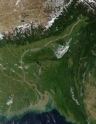
The Brahmaputra is a trans-boundary river which flows through Southwestern China, Northeastern India, and Bangladesh. It is known as Brahmaputra or Luit in Assamese, Yarlung Tsangpo in Tibetan, the Siang/Dihang River in Arunachali, and Jamuna River in Bengali. By itself, it is the 9th largest river in the world by discharge, and the 15th longest.

Tezpur is a city in Sonitpur district, Assam state, India. Tezpur is located on the banks of the river Brahmaputra, 175 kilometres (109 mi) northeast of Guwahati, and is the largest of the north bank cities.

Nagaon district is an administrative district in the Indian state of Assam. At the time of the 2011 census it was the most populous district in Assam, before Hojai district was split from it in 2016.

Sonitpur district [Pron: ˌsə(ʊ)nɪtˈpʊə or ˌʃə(ʊ)nɪtˈpʊə] is an administrative district in the state of Assam in India. The district headquarters is located at Tezpur.

The Dooars or Duars are the alluvial floodplains in eastern-northeastern India and southern Bhutan that lie south of the outer foothills of the Himalayas and north of the Brahmaputra River basin. This region is about 30 km (19 mi) wide and stretches over about 350 km (220 mi) from the Teesta River in West Bengal to the Dhansiri River in Udalguri district of Assam. The region forms the gateway to Bhutan. It is part of the Terai-Duar savanna and grasslands ecoregion.
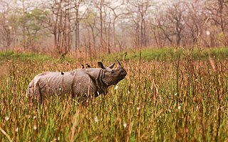
Orang National Park is a national park in India located on the northern bank of the Brahmaputra River in the Darrang and Sonitpur districts of Assam. It covers an area of 79.28 km2 (30.61 sq mi). It was established as a sanctuary in 1985 and declared a national park on 13 April 1999. It is rich in flora and fauna, including great Indian rhinoceros, pygmy hog, Asian elephant, wild water buffalo and the Bengal tiger. It is the only stronghold of the rhinoceros on the north bank of the Brahmaputra.
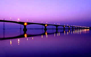
Kolia Bhomora Setu, an existing bridge completed in 1987, is a 3.015 km long pre-stressed concrete road bridge on NH-715 over the Brahmaputra River in Tezpur Assam state of India, which connects Tezpur in Sonitpur district on northern bank with Kaliabor in Nagaon District on the south bank. It is named after the Ahom General Kolia Bhomora Phukan. A new Bhomoraguri-Tezpur Bridge 3.040 km long, few meters parallel to the existing Kolia Bhomora Setu, is opened in 2021.
The Brahmaputra Valley is a region situated between hill ranges of the eastern and northeastern Himalayan range in Eastern India.

Dihing or Burhi Dihing is a large tributary, about 380 kilometres (240 mi) long, of the Brahmaputra River in Upper Assam in northeastern India. The river originates at 2,375 metres (7,792 ft) above sea level in the Eastern Himalayas in Arunachal Pradesh and flows through Tinsukia and Dibrugarh Districts in Assam to its confluence with the Brahmaputra at Dihingmukh. Its watershed covers about 6,000 square kilometres (2,300 sq mi). The Dihing has created number of oxbow lakes in the area.
The Kameng River in the eastern Himalayan mountains, originates in Tawang district from the glacial lake below snow-capped Gori Chen mountain 27°48′36″N92°26′38″E, elevation 6,300 metres (20,669 ft), on the India-Tibet border and flows through Bhalukpong circle of West Kameng District, Arunachal Pradesh and Sonitpur District of Assam, India. It becomes a braided river in its lower reaches and is one of the major tributaries of the Brahmaputra River, joining it at Tezpur, just east of the Kolia Bhomora Setu bridge.

Upper Assam is an administrative division of the state of Assam comprising the undivided Lakhimpur and Sivasagar districts, of the upper reaches of the Brahmaputra valley. The other divisions are: Lower Assam, North Assam and Hills and Barak Valley. The division is under the jurisdiction of a Commissioner, stationed at Jorhat.
Panchigaon is a village in Sonitpur district, in the state of Assam in India. The village is located at the north bank of Brahmaputra River towards the town of Jamugurihat.

Biswanath is an administrative district in the state of Assam in India. It is one of newly created district in the year by 2015, declared by Assam Chief Minister Tarun Gogoi on 15 August 2015.
Sootea is located under Naduar revenue circle, under Tezpur sub-division, formerly in the district of Sonitpur but at present in the district of Biswanath, Assam state, India.
Tezpur College, established in 1965, is a undergraduate, coeducational college situated in Tezpur, Assam. The college is affiliated with the Gauhati University.
The Brahmaputra floods refers to a catastrophic flood event that occurred in 2012 along the Brahmaputra River and its tributaries, as well as in subsequent years.
The Baralia River is a sub-tributary of the Brahmaputra River in the Indian state of Assam. The Baralia River originates in the Nagrijuli Tea Estate and flows through Rangia City, Nalbari district and Tamulpur district before its confluence with the Puthimari River and the Brahmaputra River. The Nona River is a tributary of the Baralia river.

The Pagladiya River is a northern bank tributary of the Brahmaputra River in the Indian state of Assam. The Pagladiya River originates in the Bhutan hills and flows through Baksa District and Nalbari district before its confluence with the Brahmaputra River. Pagladiya River is perennial, very shallow, and is characteristically known for flash floods and high discharge rates.

The Dikrong River is a sub-tributary of the Brahmaputra River in the Indian state of Assam. The Dikrong river originates in the hills of Arunachal Pradesh and flows through major cities like Nirjuli in Arunachal Pradesh and Bihpuria in Assam before its confluence with the Subansiri River.
Gamiripal, also known as Hukai Gaon or Kumar gaon, is a village in Jamugurihat of Sonitpur district, in the Indian state of Assam.

