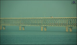
Rajahmundry, officially known as Rajamahendravaram, is a city located in East Godavari district in the Indian state of Andhra Pradesh. The city is located on the banks of Godavari River. In the Madras Presidency, the District of Rajahmundry was created in 1823. It was reorganised in 1859 and was bifurcated into Godavari and Krishna districts. During British rule, Rajahmundry was the headquarters of Godavari District, which was further bifurcated into East Godavari and West Godavari districts in 1925. When the Godavari District was bifurcated, Kakinada became the headquarters of East Godavari and Eluru became headquarters of West Godavari. It is administered under Rajahmundry revenue division. The city is known for its Floriculture, History, Culture, Agriculture, Economy, Tourism, Industrial potential and its Heritage. It is known as the Cultural Capital of Andhra Pradesh.

Dowleswaram is a part of Rajahmundry Municipal Corporation in East Godavari district of the Indian state of Andhra Pradesh. It was a census town as per 2011 Census of India and was fully included into the corporation on 18 March 2013, along with 21 panchayats. It also forms a part of Godavari Urban Development Authority.

Gollaprolu is a town in East Godavari district of the Indian state of Andhra Pradesh. It is a Municipality in Gollaprolu mandal of Kakinada revenue division. The town also forms a part of Godavari Urban Development Authority.

Hukumpeta is in Visakhapatnam district of the Indian state of Andhra Pradesh. It was a census village and a rural agglomeration constituent of Araku as per 2011 census of India, which was fully included into the corporation on 18 March 2013, along with 11 panchayats.
Mummidi-varam is a town in East Godavari district of Andhra Pradesh, India. The Mummidivaram revenue block was formed out of the Amalapuram tehsil in July 1969. It is the second largest town in Konaseema.
Rajahmundry Rural mandal, officially known as Rajamahendravaram Rural mandal, is one of the 59 mandals in East Godavari district of the state of Andhra Pradesh, India. It has its headquarters at Rajahmundry. The mandal is bounded by Seethanagaram mandal, Korukonda mandal, Rajanagaram mandal, Kadiam mandal and Atreyapuram mandal.

Howrah Sadar subdivision is a subdivision of the Howrah district in the state of West Bengal, India. It consists of Howrah municipal corporation and five community development blocs: Bally Jagacha, Domjur, Panchla, Sankrail and Jagatballavpur. The five blocks contain 67 gram panchayats and 44 census towns. The subdivision has its headquarters at Howrah.
Canning subdivision is an administrative subdivision of the South 24 Parganas district in the Indian state of West Bengal.
Lalacheruvu is a part of Rajahmundry Municipal Corporation in East Godavari district of the Indian state of Andhra Pradesh. It was merged into the corporation on 18 March 2013, alongside 21 panchayats. The village also forms a part of Godavari Urban Development Authority.
Kolamuru is a part of Rajahmundry Municipal Corporation in East Godavari district of the Indian state of Andhra Pradesh. It was fully included into the corporation on 18 March 2013, along with 21 panchayats. It also forms a part of Godavari Urban Development Authority.
Bommuru is a part of Rajahmundry Municipal Corporation in East Godavari district of the Indian state of Andhra Pradesh. It was an Out growth to the corporation, as per 2011 census of India and was fully included into the corporation on 18 March 2013, along with 21 panchayats. It also forms a part of Godavari Urban Development Authority.
Katheru is a part of Rajahmundry Municipal Corporation in East Godavari district of the Indian state of Andhra Pradesh. It was a census town and an urban agglomeration constituent of Rajahmundry as per 2011 census of India and was fully included into the corporation on 18 March 2013, along with 21 panchayats. It also forms a part of Godavari Urban Development Authority.

Bidhannagar Municipal Corporation or BMC is the local governing body responsible for the civic infrastructure and administration of Bidhannagar and Rajarhat in Greater Kolkata. This civic administrative body administers an area of 60.5 square kilometres (23.4 sq mi). The jurisdiction of BMC includes Salt Lake, Mahishbathan II Gram Panchayat and Rajarhat.

Guntur West mandal is one of the 58 mandals in Guntur district of the Indian state of Andhra Pradesh. It is under the administration of Guntur revenue division and was formed by bifurcating Guntur urban mandal into Guntur East and Guntur West, with its headquarters at Guntur.
Guntur East mandal is one of the 58 mandals in Guntur district of the Indian state of Andhra Pradesh. It is under the administration of Guntur revenue division and was formed by bifurcating Guntur urban mandal into Guntur East and Guntur West, with its headquarters at Guntur.
