Lake Wissota is a reservoir in Chippewa County, Wisconsin, United States, just east of the city of Chippewa Falls. It covers an area of 6,024 acres (2,438 ha) and has a maximum depth of 72 feet (22 m).

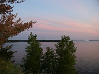
The Great Sacandaga Lake is a large lake situated in the Adirondack Park in northern New York in the United States. The lake has a surface area of about 41.7 square miles (108 km2) at capacity, and the length is about 29 miles (47 km). The word Sacandaga means "Land of the Waving Grass" in the native Mohawk language. The lake is located in the northern parts of Fulton County and Saratoga County near the southern border of the Adirondack Park. A small portion also extends northward into southern Hamilton County. The broader, south end of the lake is northeast of the City of Johnstown and the City of Gloversville. Great Sacandaga Lake is a reservoir created by damming the Sacandaga River. The primary purpose for the creation of the reservoir was to control flooding on the Hudson River and the Sacandaga River, floods which had a historically significant impact on the surrounding communities.

Lake Oroville is a reservoir formed by the Oroville Dam impounding the Feather River, located in Butte County, northern California. The lake is situated 5 miles (8 km) northeast of the city of Oroville, within the Lake Oroville State Recreation Area, in the western foothills of the Sierra Nevada. Known as the second-largest reservoir in California, Lake Oroville is treated as a keystone facility within the California State Water Project by storing water, providing flood control, recreation, freshwater releases to assist in controlling the salinity intrusion into the Sacramento-San Joaquin Delta and protecting fish and wildlife.

J. Percy Priest Lake is a reservoir in north central part of Tennessee. It is formed by J. Percy Priest Dam, located between miles six and seven of the Stones River. The dam is located about 10 miles (16 km) east of downtown Nashville and impounds a lake 42 mi (68 km) long. The lake and dam are named for Congressman Percy Priest.

Codorus State Park is a 3,500-acre (1,400 ha) Pennsylvania state park in Heidelberg, Manheim, Penn, and West Manheim Townships in southwestern York County, Pennsylvania in the United States. The park was created around Lake Marburg, an artificial lake covering 1,275 acres (516 ha), and is named for Codorus Creek, which forms the lake. Codorus State Park is located on Pennsylvania Route 216, 3 miles (4.8 km) from the borough of Hanover.

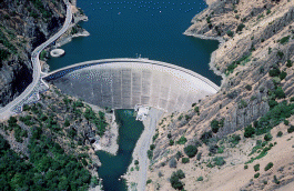
The San Luis Reservoir is an artificial lake on San Luis Creek in the eastern slopes of the Diablo Range of Merced County, California, approximately 12 mi (19 km) west of Los Banos on State Route 152, which crosses Pacheco Pass and runs along its north shore. It is the fifth largest reservoir in California. The reservoir stores water taken from the San Joaquin-Sacramento River Delta. Water is pumped uphill into the reservoir from the O'Neill Forebay which is fed by the California Aqueduct and is released back into the forebay to continue downstream along the aqueduct as needed for farm irrigation and other uses. Depending on water levels, the reservoir is approximately nine miles (14 km) long from north to south at its longest point, and five miles (8 km) wide. At the eastern end of the reservoir is the San Luis Dam, the fourth largest embankment dam in the United States, which allows for a total capacity of 2,041,000 acre-feet (2,518,000 dam3). Pacheco State Park lies along its western shores.

The West Canada Creek is a 76-mile-long (122 km) river in upstate New York, United States. West Canada Creek is an important water way in Hamilton, Oneida, and Herkimer counties, draining the south part of the Adirondack Mountains before emptying into the Mohawk River near the Village of Herkimer. The name "Canada" is derived from an Iroquoian word for "village" (Kanata).

Rensselaer Lake is an artificial lake in Albany, New York, United States named for Major-General Stephen Van Rensselaer, last patroon of Rensselaerswyck. The lake was Albany's first municipally-owned source of water. It is part of a 57-acre (23 ha) park and the state's Albany Pine Bush Preserve. The lake and park have been under the purview of the Albany Water Authority since 2003.

Castaic Lake is a reservoir formed by Castaic Dam on Castaic Creek, in the Sierra Pelona Mountains of northwestern Los Angeles County, California, United States, near the town of Castaic.

Fishkill Creek is a tributary of the Hudson River in Dutchess County, New York, United States. At 33.5 miles (53.9 km) it is the second longest stream in the county, after Wappinger Creek. It rises in the town of Union Vale and flows generally southwest to a small estuary on the Hudson just south of Beacon. Part of its 193-square-mile (500 km2) watershed is in Putnam County to the south. Sprout Creek, the county's third-longest creek, is its most significant tributary. Whaley and Sylvan lakes and Beacon Reservoir, its largest, deepest and highest lakes, are among the bodies of water within the watershed.

Lake Rabun is a twisty 835-acre (3.4 km2) reservoir with 25 miles (40 km) of shoreline located in the Northeastern corner of the U.S. state of Georgia in Rabun County. It is the third lake in a six-lake series that follows the original course of the Tallulah River. The series begins with Lake Burton as the northernmost lake, followed by Lake Seed, Lake Rabun, Lake Tallulah Falls, Lake Tugalo, and Lake Yonah. Lake Rabun was built in a deep valley located along a 10-mile (16 km) section of the Tallulah River.

Lake Burton is a 2,775 acres (11.23 km2) reservoir with 62 miles (100 km) of shoreline located in the northeastern corner of Georgia in Rabun County. The lake is owned and administered by the Georgia Power/Southern Company, but it is a public lake. Noted for the remarkable clarity of its water and surrounded by the biodiverse ecosystem of the Blue Ridge Mountains, the lake celebrated its centennial in 2020.
Monticello Dam is a 304-foot (93 m) high concrete arch dam in Napa County, California, United States, constructed between 1953 and 1957. The dam impounded Putah Creek to create Lake Berryessa in the Vaca Mountains.

Lackawanna State Park is a 1,445-acre (585 ha) Pennsylvania state park in Benton and North Abington Townships, Lackawanna County, Pennsylvania in the United States. Lake Lackawanna, a 198-acre (80 ha) man-made lake, is the central focus of recreation at the park. Lackawanna State Park is located near Dalton on Pennsylvania Route 524 just off exit 199 of Interstate 81.

John Redmond Reservoir is a reservoir on the Neosho River in eastern Kansas. Built and managed by the U.S. Army Corps of Engineers, it is used for flood control, recreation, water supply, and wildlife management. It borders the Flint Hills National Wildlife Refuge to the northwest.

Calero Reservoir, also called Calero Lake, is a reservoir in San Jose, California, located in the Calero neighborhood of Almaden Valley in South San Jose. It is the site of Calero County Park, which also includes a large area covering the lake and hundreds of acres of hills around it.

The Eklutna Dam, also referred to as the New Eklutna Dam or Upper Eklutna Dam, is an embankment dam on the Eklutna River about 30 mi (48 km) northeast of Anchorage in Alaska, United States. The primary purpose of the dam is hydroelectric power generation and it supports a 47 MW power plant. It was first completed in 1929 but was rehabilitated or rebuilt on several occasions over its history. Ownership of the dam and power plant is shared by Chugach Electric and Matanuska Electric.

The Metro Vancouver watersheds, also known as the Greater Vancouver watersheds, supply potable water to approximately 2.7 million residents in the Lower Mainland of British Columbia. They provide tap water to a land area covering more than 2,600 square kilometres (1,000 sq mi), serving a total of 21 member municipalities, one electoral district, and one treaty First Nation. From west to east, the watersheds are the Capilano, the Seymour, and the Coquitlam. They are located in the North Shore Mountains and Coquitlam Mountain, respectively. Each watershed possesses a reservoir for water storage purposes, under the control of Metro Vancouver. The reservoirs are supplied by about 3.5 metres (11 ft) of rain and 4.5 metres (15 ft) of snowpack annually. Two additional off-catchment areas under control of Metro Vancouver contribute to the water supply. The watersheds have a long history of controversies surrounding logging, highway development, and salmon run conservation.
Moccasin Dam is a small dam on Moccasin Creek in Tuolumne County, California, in the town of Moccasin, west of Yosemite. It holds the Moccasin Reservoir. The dam, reservoir and associated hydroelectric power plant are part of the Hetch Hetchy Project, which provide water and power to the city of San Francisco. The dam is located near the junction of Highway 120 and Highway 49.

Vasona Reservoir is an artificial lake located in Los Gatos, California, United States. A 152-acre (62 ha) county park surrounds the reservoir and provides limited fishing, picnicking, and informal play activities. Although swimming is not allowed, human-powered boating is permitted in the reservoir.


