Gambe, a village in Tola-Binyeri District of the Mayo-Belwalocal government area of Adamawa State in the North Eastern region of Nigeria, is an ancient settlement dating back to about the seventeenth century about 1750AD. Founded by Gangve the first Chief of Gambe. From whose name is derived the Corrupted pronunciation Gambe. The town is not to be confused with Gombe, Gombe State.
Gambe Village is in Gangfada Ward. Gambe has 6 polling unit out of twelve in the ward. Currently a Village is headed by the Traditional Council Village Head who is Under the Leadership of the District Head at Tola Headquarters of Tola-Binyeri District.
The village mostly settled by small scale farmers produce agricultural produce such as Groundnuts, Irish Potatoes, Pear, Mango, Palm Kernel, Mountain Honey and many other rear species of plants like Atile, etc. The main market day is every Saturday of the week where all sort of local produce as well as manufactured products are sold to buyers.
Geography
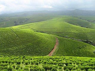
Gambe is a settlement on the fringes of the Sebshi Mountain ranges. Located near the confluence of River 'Da jara' and River 'Da Boghdu' they are tributaries of the Benue River that flow from 'Doba' Mountain peak down to Gambe flowing Northwards to the Benue River.
Natural Resources
Gambe village contains a range of minerals including barite, agate, quartz, sapphire, ruby, tourmaline and fossils.
The People of Gambe
Gambe is the home to the Chamba people, a tribe in Nigeria's North East region. It is also the village of the first Chamba University graduate: Sa'adu Abubakar[1] Gambe. He graduated from Provincial Secondary School Yola in 1964, he did HSC in Science School Lagos, he then studied Botany/Zoology Combined Honors in Ahmadu Bello University Zaria. He is known as 'Baba Gambe' Father of Gambe.
The village has a Primary School and a Junior Secondary School.
Benue State is one of the North Central states in Nigeria with a population of about 4,253,641 in 2006 census. The state was created in 1976 among the seven states created at that time. The state derives its name from the Benue River which is the second largest river in Nigeria after the River Niger. The state borders Nasarawa State to the North; Taraba State to the East; Kogi State to the West; Enugu State to the South-West; Ebonyi and Cross-Rivers States to the South; and has an international border with Cameroon to the South-East. It is inhabited predominantly by the Tiv, Idoma and Igede. Minority ethnic groups in Benue are Etulo, Igbo, Jukun peoples etc. Its capital is Makurdi. Benue is a rich agricultural region; popularly grown crops include: oranges, mangoes, sweet potatoes, cassava, soya bean, guinea corn, flax, yams, sesame, rice, groundnuts, and Palm Tree.
The North Region makes up 66,090 km2 of the northern half of The Republic of Cameroon. Neighbouring territories include the Far North Region to the north, the Adamawa Region to the south, Nigeria to the west, Chad to the east, and Central African Republic to the southeast. The city of Garoua is both the political and industrial capital. Garoua is Cameroon's third largest port, despite the fact that the Bénoué River upon which it relies is only navigable for short periods of the year.
Taraba is a state in North Eastern Nigeria, named after the Taraba River, which traverses the southern part of the state. Taraba state's capital is Jalingo. The main ethnic groups are the Fulani, Tiv, Mumuye, Mambilla, Wurkuns, Jukun, Kuteb, Yandang, Ndola, Itchen, Tigun and Jibu. The northern parts is mainly dominated by Fulani of Muri emirate. The southern parts are dominated by the Jukun, Chamba, Tiv, Kuteb and Ichen.The central region is mainly occupied by the Fulani, Mambilla and the Jibu peoples. There are over 77 different tribes, and their languages in Taraba State.
Nasarawa State is a state in the North Central region of Nigeria, bordered to the east by the states of Taraba and Plateau, to the north by Kaduna State, to the south by the states of Kogi and Benue, and to the west by the Federal Capital Territory. Named for the historic Nasarawa Emirate, the state was formed from the west of Plateau State on 1 October 1996. The state has thirteen local government areas and its capital is Lafia, located in the east of the state, while a key economic centre of the state is the Karu Urban Area—suburbs of Abuja—along the western border with the FCT.
Northern Nigeria was an autonomous division within Nigeria, distinctly different from the southern part of the country, with independent customs, foreign relations and security structures. In 1962, it acquired the territory of the British Northern Cameroons, which voted to become a province within Northern Nigeria.
Darchula District, a part of Sudurpashchim Province, is one of the nine districts of province and one of seventy-seven districts of Nepal. The district, with Khalanga as its district headquarters, covers an area of 2,322 km2 (897 sq mi) and has a population (2011) of 133,274. Darchula Lies in the west-north corner of the country.
Gombe is the capital city of Gombe State, north-eastern Nigeria, with an estimated population of 261,536. The major spoken languages in Gombe are Hausa and Fulfulɗe, Tera and Tangale.
Obudu is a local government area and town in Cross River State, Nigeria. The area features a tourist resort, Obudu Mountain Resort, which hosts an annual mountain running competition called the Obudu Ranch International Mountain Race. The town of Obudu is downstream from the Obudu Dam, which has caused acute scarcity of drinking water in the dry season. The town is approximately 17 kilometers away from Bebi Airport and is a 6-hour drive from Calabar, the capital of Cross River.
Jukun are an ethno-linguistic group or ethnic nation in West Africa. The Jukun are traditionally located in Taraba, Benue, Nasarawa, Plateau, Adamawa, Bauchi and Gombe States in Nigeria and parts of northwestern Cameroon. They are descendants of the people of Kwararafa. Most of the tribes in the north central of Nigeria trace their origin to the Jukun people and are related in one way or the other to the Jukuns. Until the coming of both Christianity and Islam, the Jukun people were followers of their own traditional religions. Most of the tribes, Alago, Agatu, Rendere, Goemai in Shendam, and others left Kwararafa when it disintegrated as a result of a power tussle. The Jukuns are divided into two major groups; the Jukun Wanu and Jukun Wapa. The Jukun Wanu are fishermen residing along the banks of the river Benue and Niger where they run through Taraba State, Benue State and Nasarawa State. The Wukari Federation, headed by the Aku Uka of Wukari, is now the main centre of the Jukun people.
Konshisha is a local government area of Benue State, Nigeria. Its headquarters are in the town of Tse-Agberagba.
Akko is a local government area of Gombe, Gombe State, Nigeria. Its headquarters is in Kumo town on the A345 highway south of the state capital Gombe, about 40 km away. Kumo (headquarter) is a cosmopolitan community of more than 30 different tribes, ranging from the dominant Fulani tribe to Tangale, Tera, Hausa and other minorities.
Billiri is one of the 11 Local Government Area of Gombe State, Nigeria bordered to the north by Akko LGA, south and east by Shongom as well as North-East by Kaltungo LGA. It is a historical settlement of the Tangales which is located South of Gombe It has an area of 737 km2 and a population of 202,144 at the 2006 census. Apart from Tangale language, Fulfulde and Hausa are commonly spoken The postal code of the area is 771.
Dukku is a Local Government Area in Gombe State, Nigeria. Its headquarters are in Dukku town. The Gongola River flows through the west and north of the LGA. It has an area of 3,815 km2 and a population of 207,190 from the 2006 census. The vast majority of the population are Muslims, but there is a Christian minority. The major ethnic group is Fulani with Fulfulde being spoken as a major language alongside Bole while Hausa, Kanuri, and Kare-Kare are also spoken.
Yamaltu/Deba is a Local Government Area of Gombe State, Nigeria. Its headquarters is in the town of Deba, at the southeastern part of the state capital, Gombe.
The Gombe Emirate is a traditional state in Nigeria that roughly corresponds in area to the modern Gombe State.The current Emir of Gombe is Alhaji Abubakar Shehu Abubakar III, who acceded on 6 June 2014. The late Emir of Gombe, Alhaji Shehu Usman Abubakar, who precedes his father Abubakar II had been Emir since August 1984.
The Kuteb people are an ethno-linguistic group in West Africa, who speak Kuteb, a Jukunoid language. Most of the Kuteb people reside in Taraba State, Nigeria.
Tola-Binyeri is a district in the Mayo Belwa local government area of Adamawa State, Nigeria. It stretches alongside the Shebshi Mountain. It has a District Head.
Lists of villages in Nigeria organised by state:
This page is based on this Wikipedia article Text is available under the CC BY-SA 4.0 license; additional terms may apply. Images, videos and audio are available under their respective licenses.