Related Research Articles
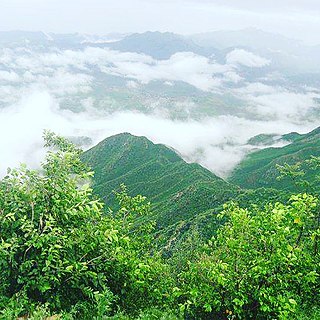
Cherat is a hill station dating from the 1860s that is located immediately above the villages of Chapri, Saleh Khana, Kotli Kalan and Dak Ismail Khel in the Nowshera District of Khyber-Pakhtunkhwa in Pakistan. Cherat lies 34 miles south east from the city of Peshawar at an elevation of 4,500 feet on the west of the Khattak range, which divides the district of Nowshera from Kohat District.

Golra Sharif is a town situated near the Margalla Hills in the Islamabad Capital Territory, Pakistan, at about 520 m (1,710 ft) above sea level, 17 km (11 mi) from the ancient city of Taxila. It is known for the Mausoleum of Meher Ali Shah that yearly attracts thousands of devotees. Prior to the arrival of Meher Ali Shah's ancestors Golra Sharif was a village in the suburbs of Rawalpindi. Naseeruddin Naseer was the great-grandson of Meher Ali Shah of Golra Sharif and the son of Syed Ghulam Moinuddin Gilani. He was the custodian of the Golra Sharif shrine in the Islamabad Capital Territory of Pakistan.

Kohat District is a district in Kohat Division of Khyber Pakhtunkhwa province in Pakistan. Kohat city is the capital of the district.

Tanda Dam or Tanda Lake is a small dam and also a lake view park located in Kohat District of Khyber Pakhtunkhwa the province of Pakistan. The dam supplies water for irrigation to Jurma, Shahpur and many villages by means of canals from Tanda Lake.
Kohat Division is one of seven divisions in Pakistan's Khyber Pakhtunkhwa province. It consists of five districts: Hangu, Karak, Kohat, Kurram, and Orakzai. According to the 2017 Pakistani Census, the division had a population of 3,211,458, making it the third-least populous division in the province, and it spans 12,377 km2 (4,779 sq mi) of area, and this makes it the fourth-largest division by area in the province. Kohat is the division's largest city and namesake, with over 220,000 inhabitants. The division borders Bannu Division to the south and west, Peshawar Division to the north and east, the province of Punjab, Pakistan to its east, and the country of Afghanistan to its northwest.

Cadet College Kohat is one of the Elite Institutions of Pakistan which Provides quality education to all segments of society on merit and competition grade 8th to 12th. The college is located on the outskirts of Kohat, Pakistan.
Karak is the headquarters of Karak District in the Khyber Pakhtunkhwa province of Pakistan. It is 123 km from Peshawar on the main Indus Highway between Peshawar and Karachi. It is located at 33°7'12N 71°5'41E. Karak is said to be the single district in Pakistan that is inhabited by only one tribe of Pashtuns — the Khattaks.
Adezai or Addezai is a town in the Peshawar District of Pakistan. It is situated about 33 kilometres (21 mi) by road south of the city of Peshawar, and is the administrative center of Adezai Union Council. The N55 road partly connects it to Peshawar in the north and Kohat via Dara Adam Khel to the south. there are many kandhi in the village. The best-known are Mughalkhel, mirzakhel, behramkhel, sadarkhel, umarkhel, khwajakhel, and misrikhel.

Bara Tehsil is a subdivision located in Khyber District, Khyber Pakhtunkhwa, Pakistan.
Teri is a village and Union Council in Karak District of Khyber Pakhtunkhwa, Pakistan. It is located at 33°18'0"N 71°6'0"E with an altitude of 634 metres (2,083 feet).
Bara is a town located in Bara Tehsil in Khyber Khyber Pakhtunkhwa, Pakistan. Kohat is located to the south while Peshawar is located to the north of Bara.

Kohat Subdivision formerly Frontier Region Kohat is a subdivision in Khyber Pakhtunkhwa province of Pakistan. The region is located adjacent to the Kohat District, and therefore derives its name from Kohat. Kohat subdivision also shares its boundary with Peshawar District to the north, Nowshera District to the east and Orakzai Agency to the west. It is administered under the overall supervision and administrative command of Deputy Commissioner (DC) Kohat. The main towns in Kohat subdivision is Darra Adam Khel and Jawaki Adam Khel.
Muslimabad Kohat is a village of Kohat District of Khyber Pakhtunkhwa, Pakistan.
Kohat Cantonment railway station (Urdu: کوہاٹ کینٹ ریلوے اسٹیشن) is located in Kohat, Pakistan. The station serves as the terminus for the Khushalgarh–Kohat–Thal Railway.
Ustarzai railway station is an abandoned railway station located in Usterzai, Kohat District, Khyber Pakhtunkhwa, Pakistan.
Bahadar Kot, 90 miles (140 km) west of Islamabad, is an administrative unit known as union council of Kohat District in the Khyber Pakhtunkhwa province of Pakistan.
Bilitang is an administrative unit known as "Union Council" of Kohat District in the Khyber Pakhtunkhwa province of Pakistan.
Nusret Khel is an administrative unit of the Kohat District in the Khyber Pakhtunkhwa province, Pakistan.
Surgul is an administrative unit known as "Union Council" of Kohat District in the Khyber Pakhtunkhwa province of Pakistan. Surgul Union Council includes three villages: Surgul, Kamardhamd and Chambai.
Togh Bala is an administrative unit known as "Union Council" of Kohat District in the Khyber Pakhtunkhwa province of Pakistan.
References
- ↑ Heron, A. M.; Bradshaw, Eric J.; Ahmad, M. I.; Khan, N. M.; Crookshank, Henry; H, Kazmi, Ali (1951). Report of the Geological Survey of Pakistan: From 15th August, 1947 to 31st December, 1949. Manager of Publications. p. 41.
Coordinates: 33°32′N71°37′E / 33.533°N 71.617°E
| | This Kohat District location article is a stub. You can help Wikipedia by expanding it. |