
Lac qui Parle County is a county in the U.S. state of Minnesota. As of the 2010 United States Census, the population was 7,259. Its county seat is Madison.

Garfield Township is a civil township of Clare County in the U.S. state of Michigan. The population was 1,882 at the 2010 census.

Farm Island Township is a township in Aitkin County, Minnesota, United States. The population was 1,099 as of the 2010 census.

Alexandria is a city in and the county seat of Douglas County, Minnesota. First settled in 1858, it was named after brothers Alexander and William Kinkead from Maryland. The form of the name alludes to Alexandria, Egypt, a center of learning and civilization.

Garfield Township is a township in Lac qui Parle County, Minnesota, United States. The population was 187 at the 2000 census.
Garfield Township is a township in Polk County, Minnesota, United States. It is part of the Grand Forks-ND-MN Metropolitan Statistical Area. The population was 391 at the 2000 census.
Mud Lake is an unorganized territory located in Marshall County, Minnesota, United States. In both the 2000 and 2010 U.S. censuses, the unorganized territory recorded a population of 0.
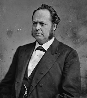
William Windom was an American politician from Minnesota. He served as U.S. Representative from 1859 to 1869, and as U.S. Senator from 1870 to January 1871, from March 1871 to March 1881, and from November 1881 to 1883. He also served two non-consecutive times as Secretary of the Treasury from March to November 1881, and from 1889 to 1891, under three Presidents. He was a Republican. He was the great-grandfather of actor William Windom, who was named for him.

The Iowa Great Lakes, often referred to as Okoboji., is a group of natural lakes in northwestern Iowa in the United States. The three principal lakes of the group are Big Spirit Lake, West Okoboji Lake, and East Okoboji Lake. They are the largest natural lakes in the state of Iowa. The largest, Spirit Lake, is 5,684 acres (2,300 ha). The lake area extends to the north into Jackson County, Minnesota. The headwaters of Little Sioux River flow past the west side of the lake area.
Interstate 535 (I-535) is a 2.78-mile-long (4.47 km) Auxiliary Interstate Highway spur route of I-35 in the U.S. states of Minnesota and Wisconsin. It is paired with U.S. Route 53 (US 53) along its entire route.

The Dirty Devil River is an 80-mile-long (130 km) tributary of the Colorado River, located in the U.S. state of Utah. It flows through southern Utah from the confluence of the Fremont River and Muddy Creek before emptying into the Colorado River at Lake Powell.

Eagle Mountain is the highest natural point in Minnesota, United States, at 2,301 feet (701 m). It is in northern Cook County, in the Boundary Waters Canoe Area Wilderness and Superior National Forest in the Misquah Hills, northwest of Grand Marais. It is a Minnesota State Historic Site.
Bachelor Lake is a lake in Brown County, Minnesota in the northeastern part of Stark township. Covering 79.80 acres, it is an officially protected water of the State of Minnesota. The lake is within the Cottonwood River Major Watershed. The lake’s elevation is 1,004 feet (306 m), and it is zoned as a shoreland area which is regulated as a shoreland management water.
Saginaw is an unincorporated area in Saint Louis County, Minnesota, United States. Although unincorporated, Saginaw has a post office with the ZIP code 55779.
Fairbanks is an unincorporated community in Fairbanks Township, Saint Louis County, Minnesota, United States; located within the Superior National Forest.
Central Lakes is an unincorporated community in Saint Louis County, Minnesota, United States.
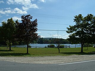
Lake Garfield is a 275-acre (111 ha) lake located about 0.5 miles (0.80 km) north of the center of Monterey, off Route 23 in Berkshire County, Massachusetts.
Island Lake is an unincorporated community in Beltrami County, in the U.S. state of Minnesota.
Wall Lake is an unincorporated community in Otter Tail County, in the U.S. state of Minnesota.
Garfield is an unincorporated community in Bonner County, in the U.S. state of Idaho. The community is situated on Garfield Bay, an inlet of Lake Pend Oreille.
