
The Gambia, officially the Republic of the Gambia, is a country in West Africa. It is the smallest country within mainland Africa and is surrounded by Senegal, except for its western coast on the Atlantic Ocean. The Gambia is situated on both sides of the lower reaches of the Gambia River, the nation's namesake, which flows through the centre of the Gambia and empties into the Atlantic Ocean. It has an area of 10,689 square kilometres (4,127 sq mi) with a population of 1,857,181 as of the April 2013 census. Banjul is the Gambian capital and the country's largest metropolitan area. The largest cities are Serekunda and Brikama.
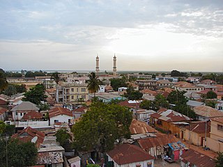
Banjul, officially the City of Banjul, is the capital and fourth largest city of The Gambia. It is the centre of the eponymous administrative division which is home to an estimated 400,000 residents, making it The Gambia's largest and most densely populated metropolitan area. Banjul is on St Mary's Island, where the Gambia River enters the Atlantic Ocean. The population of the city proper is 31,301, with the Greater Banjul Area, which includes the City of Banjul and the Kanifing Municipal Council, at a population of 413,397. The island is connected to the mainland to the west and the rest of Greater Banjul Area via bridges. There are also ferries linking Banjul to the mainland at the other side of the river.
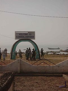
Albreda is a historic settlement in the Gambia on the north bank of the Gambia River, variously described as a 'trading post' or a 'slave fort'. It is located near Jufureh in the North Bank Division and an arch stands on the beach connecting the two places. As of 2008, it has an estimated population of 1,776.

Farafenni or Farafegni is a town in the Gambia, lying on the Trans-Gambia Highway in the North Bank Division, just south of the border with Senegal. It is an important market town.

Bakau is a town on the Atlantic coast of Gambia, west of Gambia's capital city of Banjul. It is known for its botanical gardens, its crocodile pool Bakau Kachikally and for the beaches at Cape Point. Bakau is the first major suburb outside Banjul and the most developed town in the Gambia. Close to Bakau and Banjul is Gambia's largest city, Serekunda.

Tanji is a town in Gambia, along the Atlantic coast. It is primarily a fishing town with a population of 14,531 according to the 2013 population census. The population of the town has been growing dramatically due to both urban and rural migration. This is because of its attractive fishing industry and suitable location. The Tanje Village Museum is where artisans and craftsmen engage in traditional crafts. The Tanji Bird Reserve is located 3 kilometers from the village.

Chhatarpur District is a district of Madhya Pradesh state of central India. The town of Chhatarpur is the district headquarters.
Brikama is one of eight Local Government Areas in the Gambia. Its boundaries are co-extensive with the Western administrative division. The headquarters of the Brikama LGA are located at Brikama town.
Kerewan is one of eight Local Government Areas in the Gambia. Its boundaries are co-extensive with the administrative division of North Bank. It is 60 kilometers away from the capital Banjul.
Bansang is a town in the Central River Division of the Gambia, with a population of 8,843 (2012). Although the official government center of the Division is located in Janjanbureh downstream, Bansang has better access to the more affluent coastal region of the country, and is sometimes considered the unofficial "upcountry" economic capital.
Bignona is a town with commune status located in the Ziguinchor Region of Senegal (Casamance). It briefly appears in the movie Binta and the Great Idea.

Kuntaur is a town located in the Central River Division of the Gambia.
The tourism industry today in the Gambia started when a party of 300 Swedish tourists arrived in 1965. That pioneering trip was organised by a Swede named Bertil Harding together with the tour operators Vingresor. It was seen as an ideal place to escape the harsh winter months of Scandinavia where Europeans would enjoy not only sun, sand and beaches but also experience the excitement of a real African holiday. It also offered a new opening for an affordable holiday to increasing numbers of traveling Europeans.

Bao BolongWetland Reserve is a national park in The Gambia. Established in 1996 it covers 220 square kilometres.
Bulok or Bulock is a small town in south-western Gambia. It is located in the Brikama Division. As of 2009, it has an estimated population of 2312.
Demba Kunda is a small town in south-eastern Gambia. It is located in Fulladu East District in the Upper River Division. As of 2009, it has an estimated population of 5283.

Fatoto is a small town in eastern Gambia on the Gambia River. It is located in Kantora District in the Upper River Division. As of 2009, it has an estimated population of 1,685.

Ghana Town is a small coastal fishing town in western Gambia. It is located in Kombo North/Saint Mary District in the Western Division. As of 2009, it has an estimated population of 1, 397.

Gunjur is a small coastal town in south-western Gambia. It is located in Kombo South District in the Western Division. As of 2009, it has an estimated population of 17,520.
The National Library of The Gambia is located in Banjul, Gambia. The library was originally operated by the British Council till 1946 and was renamed to the National Library of The Gambia by 1971. The library is maintained and administered by The Gambia National Library Services Authority (GNLSA). As of 2016, the library had a collection of 115,500 books and 85 periodicals. It had more than 42 staff and more than 276 members.
