Garraun (Tipperary)

Last updated

Outline map of Borrisleigh parish, showing Garraun townland (red) and the fact that it contains exclaves of the neighbouring townland of Borris GarraunTownlandInBorrisleighCivilParish2.jpg
Outline map of Borrisleigh parish, showing Garraun townland (red) and the fact that it contains exclaves of the neighbouring townland of Borris

Garraun is a townland, containing a little over 567 acres, in Twomileborris civil parish in County Tipperary. [1]

In its south-eastern corner it encloses two very small exclaves of the neighbouring townland of Borris. [2] In recent years, the village of Two-Mile Borris, whose core is in Borris townland, has expanded westwards across the townland boundary, with the result that south-eastern Garraun now contains part of the village, in the shape of a new housing area called Dún na Rí.[ citation needed ]

Although Garraun is in Borrisleigh civil parish, it is not in the electoral division of the same name (which is now more commonly called Twomileborris); instead, it is in Rahelty electoral division. [3]

Population

At the time of the 1891 census, the townland had 61 inhabitants. The population had dropped slightly to 59 by 1901 and had dropped again by 1911, when there were only 36 inhabitants, of whom 18 were male and 18 female. [4] This trend has been reversed in recent years, primarily due to the construction of the new housing area called Dún na Rí which was mentioned above, most of whose houses were built in the south-eastern corner of Garraun, just south of the two enclaves of Borris [5] (although some of the houses are actually in a finger of Blackcastle townland which projects into the south-eastern corner of Garraun).[ citation needed ]

The south-eastern corner of Garraun (red) and its environs SouthEasternGarraunTownlandInBorrisleighCivilParish2.jpg
The south-eastern corner of Garraun (red) and its environs

It is not possible to give a figure for the population of Garraun townland at the time of the 2011 census, because the website of the Irish Central Statistics Office merges the townland into "small Area number 217145002", [6] which also includes the townlands of Coldfields and Rathmanna (also from Borrisleigh civil parish), as well as those of Loughbeg and Lisduff (from Rahelty civil parish) and Ballygammane (from Thurles civil parish). An indication of the population trend can, however, be seen by comparing the 2011 figures for the "small area" with the total figures for its constituent townlands at the time of previous censuses. In 1891 these townlands, taken together, had a total population of 163, which dropped to 153 in 1901 and dropped further in 1911, to 147 of which 79 were male and 68 female. [7] In 2011, the total population for the "small area" had risen, to 241, of which males numbered 123 and females 118. [8] Most of this increase is due to the construction of Dún na Rí.[ citation needed ]

Related Research Articles

<span class="mw-page-title-main">Kinvara</span> Village in south County Galway, Ireland

Kinvara or Kinvarra is a sea port village in the southwest of County Galway, Ireland. It is located in the civil parish of Kinvarradoorus in the north of the barony of Kiltartan. Kinvarra is also an electoral division.

<span class="mw-page-title-main">Electoral division (Ireland)</span> Statistical division in Ireland

An electoral division is a legally defined administrative area in the Republic of Ireland, generally comprising multiple townlands, and formerly a subdivision of urban and rural districts. Until 1996, EDs were known as district electoral divisions in the 29 county council areas and wards in the five county boroughs. Until 1972, DEDs also existed in Northern Ireland. The predecessor poor law electoral divisions were introduced throughout the island of Ireland in the 1830s. The divisions were used as local-government electoral areas until 1919 in what is now the Republic and until 1972 in Northern Ireland.

Borris may refer to:

<span class="mw-page-title-main">Twomileborris (civil parish)</span> Civil Parish in Munster, Ireland

Twomileborris is a civil parish in the barony of Eliogarty, County Tipperary.

<span class="mw-page-title-main">Ballymurreen</span>

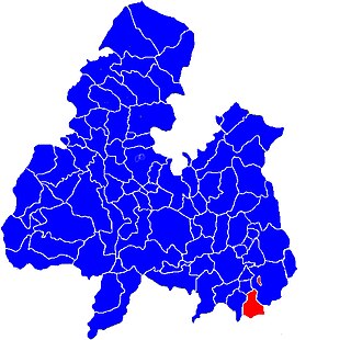
Ballymurreen, also written Ballymoreen, is a civil parish and an electoral division in County Tipperary, Ireland. It is one of 21 civil parishes in the barony of Eliogarty.

<span class="mw-page-title-main">Littleton (electoral division)</span>

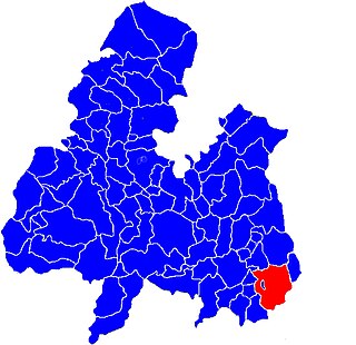
Littleton is an electoral division in County Tipperary in Ireland. The code number assigned it by the Central Statistics Office is 22071.

<span class="mw-page-title-main">Twomileborris (electoral division)</span> Electoral division in County Tipperary, Ireland

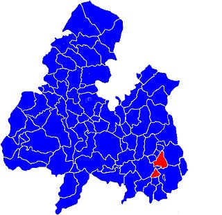
Originally called Burris poor law electoral division, and sometimes called Borrisleigh in the past, this electoral division in County Tipperary in Ireland is now known as Twomileborris.

<span class="mw-page-title-main">Rahelty (civil parish)</span>

Rahelty, sometimes written Rahealty, is a civil parish in County Tipperary, Ireland. It is one of 21 civil parishes in the historical barony of Eliogarty. It contains eighteen townlands:

<span class="mw-page-title-main">Borris, Twomileborris</span>

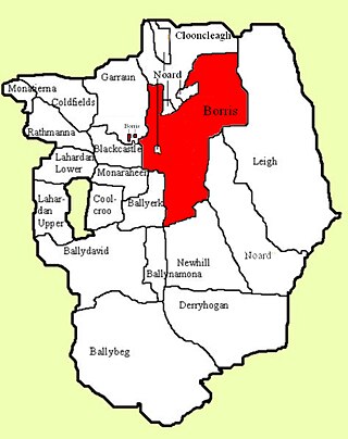
Borris is a townland comprising a little over 1,327 acres in the civil parish of Twomileborris in County Tipperary, Ireland. At the time of the 1891 census, it had a population of 212; in 1891 this had fallen to 175 but had risen again to 190 at the time of the 1911 census.

Knockroe is a townland containing a little over 363 acres in Moycarky civil parish and in the ecclesiastical parish of Moycarkey, Littleton, Two-Mile-Borris, in County Tipperary, Ireland.

Rathmanna is a townland containing just over 45 acres in Rahelty civil parish in County Tipperary. It should not be confused with the much larger townland of the same name just across the border in Borrisleigh civil parish.

Rathmanna is a townland containing just over 240 acres in Borrisleigh civil parish in County Tipperary. It should not be confused with the much smaller townland of the same name just across the border in Rahelty civil parish.

Clarbally is a townland in the civil parish of Templeport, County Cavan, Ireland. It lies in the Roman Catholic parish of Corlough and barony of Tullyhaw.

<span class="mw-page-title-main">Coologe</span> Townland in County Cavan, Ireland

Coologe is a townland in the civil parish of Templeport, County Cavan, Ireland. It lies in the Roman Catholic parish of Templeport and barony of Tullyhaw.

Altcrock is a townland in the civil parish of Templeport, County Cavan, Ireland. It lies in the Roman Catholic parish of Corlough and barony of Tullyhaw.

Cornacleigh is a townland in the civil parish of Templeport, and barony of Tullyhaw, County Cavan, Ireland. The local pronunciation is Curnacloyche.

<span class="mw-page-title-main">Tullytrasna</span> Townland in the civil parish of Templeport, County Cavan, Ireland

Tullytrasna is a townland in the civil parish of Templeport, County Cavan, Ireland. It lies in the Roman Catholic parish of Corlough and barony of Tullyhaw.

<span class="mw-page-title-main">Tullynamoltra</span>

Tullynamoltra is a townland in the civil parish of Templeport, County Cavan, Ireland. It lies in the Roman Catholic parish of Corlough and barony of Tullyhaw. The local pronunciation is tully-na-MOIL-tra.

Gubnagree is a townland in the civil parish of Templeport, County Cavan, Ireland. It lies in the Roman Catholic parish of Corlough and barony of Tullyhaw.

<span class="mw-page-title-main">Greaghnadoony</span> Townland in County Cavan, Ireland

Greaghnadoony is a townland in the civil parish of Templeport, County Cavan, Ireland. It lies in the Roman Catholic parish of Corlough and barony of Tullyhaw.

References

  1. Borrisliegh Civil Parish
  2. "Extract from Ordnance Survey map". Archived from the original on 29 August 2012. Retrieved 3 October 2012.
  3. Irish Central Statistics Office mapping Archived 12 October 2014 at the Wayback Machine
  4. Census results for 1911, showing also the results for 1891 and 1901 [ permanent dead link ]
  5. Map of environs of Twomileborris village
  6. Irish Central Statistics Office mapping Archived 12 October 2014 at the Wayback Machine
  7. Census results for 1911, showing also the results for 1891 and 1901 [ permanent dead link ]
  8. Irish Central Statistics Office mapping Archived 12 October 2014 at the Wayback Machine