Twomileborris (electoral division)

Last updated

Location and extent of the division TwomileborrisElectoralDivisionNorthTipperary.jpg
Location and extent of the division

Originally called Burris poor law electoral division, and sometimes called Borrisleigh in the past, this electoral division in County Tipperary in Ireland is now known as Twomileborris.

Contents

Extent

This electoral division comprises the townlands of Blackcastle, Borris, Clooncleagh, Leigh, Newhill and Noard. (The map of the division given the Central Statistics Office website [1] does not include the two very small exclaves of Borris townland which are surrounded by Garraun townland. This is probably an error since, at the time provision was first made for the creation of divisions, the legislation, dated 15 March 1839, provided that townlands should not be divided between electoral divisions. [2] In any event, the issue does not, at present, have practical consequences since, at present, there are no dwellings, and therefore no residents, in these two exclaves. [3] )

The division should not be confused with either the village of Twomileborris or the civil parish of Borrisleigh because it is a distinct entity. The division contains only the north-eastern section of the civil parish, the rest of which is in the neighbouring divisions of Littleton and Rahelty; [1] although Twomileborris division contains most of the village of the same name, it does not contain all of it; the new housing area of Dún Na Rí is actually in the townland of Garraun [3] which, although part of Borrisleigh civil parish, is actually in Rahelty electoral division. [1]

History

Twomileborris (Burris/Borrisleigh) electoral division was originally created in 1839, as an electoral division in the Thurles poor law union in North Tipperary. [4] [5] Although the poor law unions have long been abolished, this electoral division is still used for various administrative purposes, although with boundaries that have been modified over the years.[ citation needed ]

It would appear that Borrisleigh electoral division must have been reduced in size over the years because, when Thurles poor law union was created in 1839, Littleton electoral division, which now contains much of the land belonging to Borrisleigh civil parish, was not created. [6] It is likely, therefore, that, when Littleton division was created, land was taken from Borrisleigh division. However, by the time of the 1891 census, the division had been assigned its current extent, [7] although this may have happened even earlier.[ citation needed ]

Population

At the time of the 1891 census, the population of this electoral division was 497. In 1901, it had dropped to 437. It had increased again by 1911, when there were 475 people in the division, of which 237 were male and 238 female. [7]

The total population in the division at the time of the 2011 census was 807, of which males numbered 420 and females were 387. The total housing stock was 305, of which vacant households numbered 25. [8]

Related Research Articles

A poor law union was a geographical territory, and early local government unit, in Great Britain and Ireland.

Borris may refer to:

<span class="mw-page-title-main">Littleton, County Tipperary</span> Village in Munster, Ireland

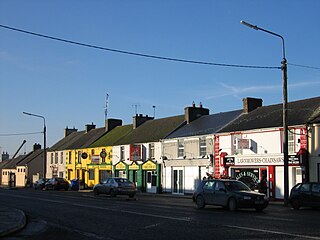
Littleton is a village in County Tipperary, Ireland. It is within the townlands of Ballybeg and Ballydavid, about 18 km (11 mi) northeast of Cashel and to the southeast of Thurles. By-passed by the M8 in December 2008, Littleton lies at a crossroads on the R639 road. Its population was 394 at the 2016 census. It is in the barony of Eliogarty.

<span class="mw-page-title-main">Twomileborris (civil parish)</span> Civil Parish in Munster, Ireland

Twomileborris is a civil parish in the barony of Eliogarty, County Tipperary.

<span class="mw-page-title-main">Ballymurreen</span>

Ballymurreen, also written Ballymoreen, is a civil parish and an electoral division in County Tipperary, Ireland. It is one of 21 civil parishes in the barony of Eliogarty.

Moycarkey is a hamlet in North Tipperary, Ireland.

<span class="mw-page-title-main">Moycarky (townland)</span>

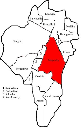
Moycarky is a townland in the civil parish of the same name and in the ecclesiastical parish of Moycarkey, Littleton, Two-Mile-Borris, in County Tipperary, Ireland.

<span class="mw-page-title-main">Noard</span> Townland (administrative division) in Ireland

Noard is a townland in the civil parish of Twomileborris, County Tipperary. In addition to its main body, the townland has four exclaves, located in other townlands within the parish.

<span class="mw-page-title-main">Moycarkey (electoral division)</span> Electoral division in Tipperary, Ireland

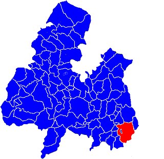
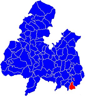
Moycarkey is an electoral division in County Tipperary in Ireland. It was originally an electoral division in the Thurles Poor Law Union in North Tipperary but is still used for various administrative purposes.

<span class="mw-page-title-main">Thurles Poor Law Union</span>

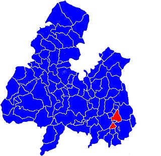
Thurles Poor Law Union, was an Irish Poor law union officially declared on 28 March 1839. It covered an area of 195 square miles (510 km2), mostly in North Tipperary but also including some of South Tipperary. Although the boundaries of some poor law unions changed during the course of the 19th century, the Thurles union seems to have retained its original boundaries.

Thurles is a town in North Tipperary.

<span class="mw-page-title-main">Buolick</span> Civil parish in County Tipperary, Ireland

Buolick is a civil parish in County Tipperary, Ireland. It is one of nineteen civil parishes in the barony of Slievardagh. Buolick, also sometimes written as Boolick or Baolick, is also an electoral division in County Tipperary. The electoral division, originally in the Thurles Poor Law Union, is largely coterminous with Buolick civil parish. The village of Gortnahoo lies within the civil parish.

<span class="mw-page-title-main">Littleton (electoral division)</span>

Littleton is an electoral division in County Tipperary in Ireland. The code number assigned it by the Central Statistics Office is 22071.

<span class="mw-page-title-main">Rahelty (electoral division)</span>

Rahealty, or Rahelty, is an electoral division in County Tipperary in Ireland.

<span class="mw-page-title-main">Rahelty (civil parish)</span>

Rahelty, sometimes written Rahealty, is a civil parish in County Tipperary, Ireland. It is one of 21 civil parishes in the historical barony of Eliogarty. It contains eighteen townlands:

<span class="mw-page-title-main">Borris, Twomileborris</span>

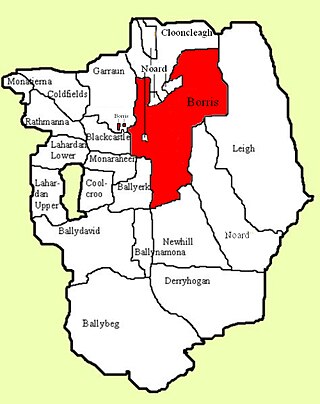
Borris is a townland comprising a little over 1,327 acres in the civil parish of Twomileborris in County Tipperary, Ireland. At the time of the 1891 census, it had a population of 212; in 1891 this had fallen to 175 but had risen again to 190 at the time of the 1911 census.

Knockroe is a townland containing a little over 363 acres in Moycarky civil parish and in the ecclesiastical parish of Moycarkey, Littleton, Two-Mile-Borris, in County Tipperary, Ireland.

Rathmanna is a townland containing just over 45 acres in Rahelty civil parish in County Tipperary. It should not be confused with the much larger townland of the same name just across the border in Borrisleigh civil parish.

Rathmanna is a townland containing just over 240 acres in Borrisleigh civil parish in County Tipperary. It should not be confused with the much smaller townland of the same name just across the border in Rahelty civil parish.

<span class="mw-page-title-main">Garraun (Tipperary)</span> Townland in Tipperary, Ireland

Garraun is a townland, containing a little over 567 acres, in Twomileborris civil parish in County Tipperary.

References