
County Tipperary is a county in Ireland. It is in the province of Munster and the Southern Region. The county is named after the town of Tipperary, and was established in the early 13th century, shortly after the Norman invasion of Ireland. It is Ireland's largest inland county and shares a border with eight counties, more than any other. The population of the county was 159,553 at the 2016 census. The largest towns are Clonmel, Nenagh and Thurles.
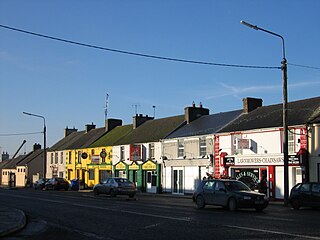
Littleton is a village in County Tipperary, Ireland. It is within the townlands of Ballybeg and Ballydavid, about 18 km (11 mi) northeast of Cashel and to the southeast of Thurles. By-passed by the M8 in December 2008, Littleton lies at a crossroads on the R639 road. Its population was 394 at the 2016 census. It is in the barony of Eliogarty.
Twomileborris is a civil parish in the barony of Eliogarty, County Tipperary.
Ballymoreen, also written Ballymurreen, is a civil parish in County Tipperary, Ireland. It is one of 21 civil parishes in the barony of Eliogarty.
Ballymoreen, or Ballymurreen, is a townland in the civil parish of the same name in County Tipperary in Ireland. It is within the historical barony of Eliogarty in the south-east corner of North Tipperary, between Littleton and Horse and Jockey. Evidence of ancient settlement in Ballymurreen include a number of ringfort sites, a ruined church and graveyard dating to at least the 17th century, and the former site of a tower house and bawn. The townland, which is 1.3 square kilometres (0.5 sq mi) in area, had a population of 65 as of the 2011 census.
Rathinch is a townland in the civil parish of Ballymurreen, County Tipperary. At the time of the 1911 census, there were three households, containing people of four different surnames in the townland. According to death notices appearing in 2012, the townland still contained people bearing the two latter surnames.
Moycarkey is a hamlet in North Tipperary, Ireland.
Galbooly or Boly, or Galvoly is a civil parish in County Tipperary, Ireland. It is one of 21 civil parishes in the barony of Eliogarty. It has area of 1268 acres, divided into six townlands:

Moycarkey is an electoral division in County Tipperary in Ireland. It was originally an electoral division in the Thurles Poor Law Union in North Tipperary but is still used for various administrative purposes.

Thurles Poor Law Union, was an Irish Poor law union officially declared on 28 March 1839. It covered an area of 195 square miles (510 km2), mostly in North Tipperary but also including some of South Tipperary. Although the boundaries of some poor law unions changed during the course of the 19th century, the Thurles union seems to have retained its original boundaries.

Buolick is a civil parish in County Tipperary, Ireland. It is one of nineteen civil parishes in the barony of Slievardagh. Buolick, also sometimes written as Boolick or Baolick, is also an electoral division in County Tipperary. The electoral division, originally in the Thurles Poor Law Union, is largely coterminous with Buolick civil parish. The village of Gortnahoo lies within the civil parish.

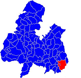
Ballymurreen, sometimes written Ballymoreen, is an electoral division in County Tipperary in Ireland. The code number assigned it by the Central Statistics Office is 22062.

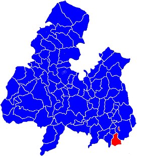
Originally called Burris poor law electoral division, and sometimes called Borrisleigh in the past, this electoral division in County Tipperary in Ireland is now known as Twomileborris.

Rahealty, or Rahelty, is an electoral division in County Tipperary in Ireland.
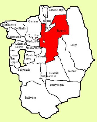
Borris is a townland comprising a little over 1,327 acres in the civil parish of Twomileborris in County Tipperary, Ireland. At the time of the 1891 census, it had a population of 212; in 1891 this had fallen to 175 but had risen again to 190 at the time of the 1911 census.
Knockroe is a townland containing a little over 363 acres in Moycarky civil parish and in the ecclesiastical parish of Moycarkey, Littleton, Two-Mile-Borris, in County Tipperary, Ireland.
Rathmanna is a townland containing just over 45 acres in Rahelty civil parish in County Tipperary. It should not be confused with the much larger townland of the same name just across the border in Borrisleigh civil parish.
Rathmanna is a townland containing just over 240 acres in Borrisleigh civil parish in County Tipperary. It should not be confused with the much smaller townland of the same name just across the border in Rahelty civil parish.

Garraun is a townland, containing a little over 567 acres, in Twomileborris civil parish in County Tipperary.
