The River Taff is a river in Wales. It rises in the Brecon Beacons as two rivers, the Taf Fechan and the Taf Fawr before becoming one just north of Merthyr Tydfil. At Cardiff, it empties into the Bristol Channel.

Burton is a small village, parish and community in Pembrokeshire, Wales, set on a hill overlooking the River Cleddau with views of the estuary to the south, east and west. The community includes the village of Hill Mountain.

Llawhaden is a village, parish and community in mid-Pembrokeshire, West Wales, historically in the Hundred of Dungleddy. The community of Llawhaden includes the parish of Robeston Wathen, part of Narberth and the hamlet of Gelli, and had a population of 634 in 2001, increasing to 688 at the 2011 Census.

Llanfair Talhaiarn, abbreviated to Llanfair TH, is a village and community approximately 5 miles (8.0 km) south of Abergele in Conwy county borough, Wales. Until 1974 it was included in Denbighshire. The population was 979 in 2001, increasing to 1,070 at the 2011 census with 44% being Welsh language speakers.

Lawrenny is a village and parish in the community and electoral ward of Martletwy in the county of Pembrokeshire, Wales. It is on a peninsula of the River Cleddau estuary upriver from Milford Haven where it branches off towards the Cresswell and Carew Rivers and is in the Pembrokeshire Coast National Park.
Slebech was a community in Pembrokeshire, Wales, which is now part of the combined community of Uzmaston and Boulston and Slebech, a sparsely populated community on the northern shore of the Eastern River Cleddau. The community shares boundaries with the communities of Wiston and Llawhaden and mainly consists of farmland and woodland. Much of the community is within the Pembrokeshire Coast National Park and Picton Castle's stable block loft is an important breeding roost for the rare Greater Horseshoe Bat.

The Wye Bridge in Monmouth is a bridge across the River Wye. The A466 passes over it and immediately meets the A40 at its western end. The bridge is a grade II listed building. The total span of the bridge is 71 metres (233 ft).

In the United Kingdom, the term listed building refers to a building or other structure officially designated as being of special architectural, historical, or cultural significance; Grade I structures are those considered to be "buildings of exceptional interest". Listing was begun by a provision in the Town and Country Planning Act 1947. Once listed, strict limitations are imposed on the modifications allowed to a building's structure or fittings. In Wales, the authority for listing under the Planning Act 1990 rests with Cadw.

Monmouthshire is a county and principal area of Wales. It borders Torfaen and Newport to the west; Herefordshire and Gloucestershire to the east; and Powys to the north. The largest town is Abergavenny, with the other major towns being Chepstow, Monmouth, and Usk. The county is 850 km2 in extent, with a population of 95,200 as of 2020. The present county was formed under the Local Government (Wales) Act 1994, which came into effect in 1996, and comprises some sixty percent of the historic county. Between 1974 and 1996, the county was known by the ancient title of Gwent, recalling the medieval Welsh kingdom. In his essay on local government in the fifth and final volume of the Gwent County History, Robert McCloy suggests that the governance of "no county in the United Kingdom in the twentieth century was so transformed as that of Monmouthshire".

Rhondda Cynon Taf is a county borough in South Wales. It is located to the north-west of Cardiff and covers an area of 424 km2 (164 sq mi). In 2021 the population was approximately 237,500.

In the United Kingdom, the term listed building refers to a building or other structure officially designated as being of special architectural, historical, or cultural significance; Grade II* structures are those considered to be "particularly important buildings of more than special interest". Listing was begun by a provision in the Town and Country Planning Act 1947. Once listed, strict limitations are imposed on the modifications allowed to a building's structure or fittings. In Wales, the authority for listing under the Planning Act 1990 rests with Cadw.

In the United Kingdom, the term listed building refers to a building or other structure officially designated as being of special architectural, historical, or cultural significance; Grade II* structures are those considered to be "particularly important buildings of more than special interest". Listing was begun by a provision in the Town and Country Planning Act 1947. Once listed, strict limitations are imposed on the modifications allowed to a building's structure or fittings. In Wales, the authority for listing under the Planning Act 1990 rests with Cadw.

Monmouthshire is a county of Wales. It borders Torfaen and Newport to the west; Herefordshire and Gloucestershire to the east; and Powys to the north. The largest town is Abergavenny, with the other major towns being Chepstow, Monmouth, and Usk. The county is 850 km2 in extent, with a population of 95,200 as of 2020. The present county was formed under the Local Government (Wales) Act 1994, which came into effect in 1996, and comprises some sixty percent of the historic county. Between 1974 and 1996, the county was known by the ancient title of Gwent, recalling the medieval Welsh kingdom. In his essay on local government in the fifth and final volume of the Gwent County History, Robert McCloy suggests that the governance of "no county in the United Kingdom in the twentieth century was so transformed as that of Monmouthshire".

This is a list of the 187 Grade II*-listed buildings in the county of Pembrokeshire, Wales.

Bethesda is a small village in the community of Llawhaden, Pembrokeshire, Wales. It lies on a bend of the B4313 road in the valley of the Eastern Cleddau river a few miles north north west of Narberth.

Gelli is a small settlement in the community and parish of Llawhaden, Pembrokeshire, Wales, at the confluence of the Syfynwy and Cleddau Ddu rivers. It is 3 miles (5 km) northwest of Narberth and 8 miles (13 km) east of Haverfordwest. The nearest railway station is at Clunderwen 2 miles (3 km) to the east. There was a woollen mill in Gelli that ceased production in 1938.

Ffynone is a mansion and estate near Boncath, Pembrokeshire, Wales, in the parish of Manordeifi. The original Georgian design was by the architect John Nash, and the house was later remodelled by Inigo Thomas. It is a Grade I listed building, and its gardens and park are also listed, at Grade I, on the Cadw/ICOMOS Register of Parks and Gardens of Special Historic Interest in Wales.

The Old Bridge is a medieval two arched stone footbridge that spans the River Ogmore at Bridgend in Wales. It is not known who designed or built the bridge, however it was built in approximately 1425. The bridge was repaired in 1775 and restored both in 2005 and 2011. The bridge is a scheduled ancient monument and a grade II* listed bridge.

Nevern Bridge spans the River Nevern in the centre of Nevern, Pembrokeshire, Wales.

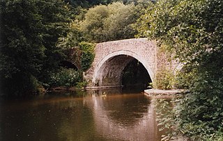
Llawhaden Bridge is a Grade II* listed medieval stone arch bridge spanning the Eastern Cleddau river near Llawhaden village in Pembrokeshire, Wales, in the community of Llawhaden and about 1 mile (1.6 km) upstream of the river's tidal limit at Canaston Bridge. It is a scheduled ancient monument.


