General Grant Mine

Last updated

General Grant Mine
General Grant Mine and Winding Plant (2012).jpg
General Grant Mine and Winding Plant, 2012
Location Off Dimbulah - Mount Mulligan Road, Kingsborough, Shire of Mareeba, Queensland, Australia
Coordinates 16°55′22″S145°01′41″E / 16.9227°S 145.028°E / -16.9227; 145.028 Coordinates: 16°55′22″S145°01′41″E / 16.9227°S 145.028°E / -16.9227; 145.028
Design period 1870s - 1890s (late 19th century)
Builtc.1878 - 1930s
Official name: General Grant Mine and Winding Plant
Type state heritage (built, archaeological)
Designated 21 October 1992
Reference no. 600683
Significant periodc.1878-1930s (fabric, historical)
Significant components workshop, shaft, chimney/chimney stack, shed - winding, machinery/plant/equipment - mining/mineral processing, shed/s, terracing, mullock heap, adit, forge/blacksmithy
Australia Queensland location map.svg
Red pog.svg
Location of General Grant Mine in Queensland
Australia location map.svg
Red pog.svg
General Grant Mine (Australia)

General Grant Mine is a heritage-listed mine off Dimbulah - Mount Mulligan Road, Kingsborough, Shire of Mareeba, Queensland, Australia. It was built from c.1878 to the 1930s. It was added to the Queensland Heritage Register on 21 October 1992. [1]

Mining The extraction of valuable minerals or other geological materials from the earth

Mining is the extraction of valuable minerals or other geological materials from the earth, usually from an ore body, lode, vein, seam, reef or placer deposit. These deposits form a mineralized package that is of economic interest to the miner.

Kingsborough, Queensland Town in Queensland, Australia

Kingsborough is a small town in the locality of Thornborough in the Shire of Mareeba, Queensland, Australia. It was part of the Hodgkinson Minerals Area.

Shire of Mareeba Local government area in Queensland, Australia

The Shire of Mareeba is a local government area at the base of Cape York Peninsula in Far North Queensland, inland from Cairns. The shire, administered from the town of Mareeba, covered an area of 53,610.8 square kilometres (20,699.2 sq mi), and existed as a local government entity from 1879 until 2008, when it amalgamated with several councils in the Atherton Tableland area to become the Tablelands Region.

Contents

History

The Hodgkinson Goldfield was proclaimed on 15 June 1876. Although the Hodgkinson was geologically similar to the great alluvial gold field to the north, the Palmer, it was predominantly a reefing field with its major mines in the vicinity of the now abandoned townships of Kingsborough, Thornborough and Northcote. It was a neglected field through lack of capital, and although there was an optimistic outlook until the first decade of the twentieth century, it was clear by 1908 that its small yield no longer justified separate goldfield administration and accordingly, in 1909 it was incorporated into the Chillagoe Gold and Mineral field. [1]

The Hodgkinson Mineral Area was a mining area near the Hodgkinson River about 80 kilometres (50 mi) west of Cairns in the present-day Shire of Mareeba in Queensland, Australia. It was the site of a gold rush in the 1870s.

Palmer, Queensland Suburb of Shire of Cook, Queensland, Australia

Palmer is a locality in the Shire of Cook, Queensland, Australia.

Thornborough, Queensland Town in Queensland, Australia

Thornborough is a town and locality in Shire of Mareeba in Queensland, Australia. It rose to prominence in the 1870s as a gold mining town in the Hodgkinson Minerals Area. Today, there are very few buildings remaining in the town. It is within the local government area of Shire of Mareeba.

There was an initial rush of over 2,000 men and up to 1877 it was estimated that over 100,000 ounces (2,800,000 g) of gold had been produced from gravel and reef; in 1878 over 44,000 ounces (1,200,000 g); then a decline until 1891, when only 655 ounces (18,600 g) was produced. Since then there was rising production to 4,853 ounces (137,600 g) in 1901. [1]

The General Grant reef up to the end of 1882 recorded seventeen crushings totalling 957 long tons (972 t) of ore yielding 1,281 ounces (36,300 g) of gold. The workings remained idle between 1883 and 1893, but in the next two years produced 1,048 long tons (1,065 t) of ore yielding 1,402 ounces (39,700 g). [1]

The revival was unexpected, but the opening of the Tablelands railway from Cairns to Mareeba in 1893 had made the field more accessible and increased use of cyanding promised improved returns for reefing fields. The real impetus came in 1897 when the British group, the Cecil Syndicate focused on the General Grant mine. [1]

Tablelands railway line, Queensland railway line in Queensland, Australia

The Tablelands line is a railway line in North Queensland, Australia. It was opened in a series of sections between 1887 and 1916. It commences at Cairns and at its maximum extent, reached Ravenshoe at the southern end of the Atherton Tableland. The rail system served by this line was unusual for Queensland in that the majority of lines that connected to it were built by private companies and later purchased by the Queensland Government.

Cairns City in Queensland, Australia

Cairns is a city in the Cairns Region, Queensland, Australia. It is on the east coast of Far North Queensland. The city is the 5th-most-populous in Queensland and ranks 14th overall in Australia.

Mareeba Town in Queensland, Australia

Mareeba is a town in Far North Queensland, Australia. The town is 417 metres (1,368 ft) above sea level on the confluence of the Barron River, Granite Creek and Emerald Creek. It is within the local government area of Shire of Mareeba. The town's name is derived from an Aboriginal word meaning meeting of the waters. In the 2011 census, Mareeba had a population of 10,181 people.

With an infusion of capital not previously witnessed in the area, the syndicate erected sophisticated surface plant and sunk the shaft to 177 metres (581 ft). Between 1898 and 1910, it returned 25,622 ounces (726,400 g) of bullion gold from 27,145 long tons (27,581 t) of ore. In 1902, when the shaft reached the reef at the 150-metre (490 ft) level the syndicate decided to erect a battery at the mine and constructed a 10,000,000-imperial-gallon (45,000,000 l; 12,000,000 US gal) capacity dam. However crushing from the mine did not even recoup the £ 8,000 outlaid on the construction of the dam, battery and cyanide plant. [1]

Australian pound currency of Australia from 1910 until 14 February 1966

The Australian pound was the currency of Australia from 1910 until 14 February 1966, when it was replaced by the Australian dollar. As with other £sd currencies, it was subdivided into 20 shillings, each of 12 pence.

Intermittent working resulted in the shaft reaching the 229-metre (751 ft) level by 1937 when it was owned by the Hodgkinson Gold Development Syndicate Limited. The reef was under consideration for dewatering and re-opening in late 1944, when it was thought that at least 8,000 long tons (8,100 t) of ore, with an average grade of 0.4 ounces (11 g) gold, remained and although the grade is said to have improved at the bottom of the workings, it was not economical. Several small prospecting efforts have been carried out since. [1]

Description

General Grant Mine at Kingsborough, 1937 General Grant Mine at Kingsborough on the Hodgkinson goldfield Queensland 1937.tif
General Grant Mine at Kingsborough, 1937

The place includes a large winding shed, workshop, and two mine shafts situated on a terrace, set high on a steep hillside. Extensive mullock dumps extend from both shafts to the base of the hill. The collar of the main shaft has caved and is strewn with the timbers of a recently collapsed headframe. [1]

The winding shed is constructed of heavy round timber uprights supporting a sawn timber frame. The building and adjacent workshop are corrugated iron clad. The building contains a winding engine, an intact Babcock boiler in a brick mount, a compressor and an air receiver. The Babcock & Wilcox boiler is equipped with a high steel chimney. A second shaft and an adit are located about 70 metres (230 ft) north-west with two colonial boilers. [1]

The surviving plant includes: [1]

Heritage listing

General Grant Mine was listed on the Queensland Heritage Register on 21 October 1992 having satisfied the following criteria. [1]

The place is important in demonstrating the evolution or pattern of Queensland's history.

The General Grant Mine is significant in Queensland's history because it was a major producer of reef gold on the Hodgkinson field between 1878 and 1910. [1]

The place demonstrates rare, uncommon or endangered aspects of Queensland's cultural heritage.

In addition, the winding shed is one of two surviving in North Queensland housing an intact range of early winding plant. (The other is located at the Great Northern Mine, Herberton) The Walkers winding engine is one of the most intact examples surveyed, while the Schran air compressor is rare. The Babcock and Wilcox boiler in its brick housing is the only intact example surviving in the Mareeba Mining District. [1]

The place is important in demonstrating the principal characteristics of a particular class of cultural places.

Isolation and difficult access has ensured the survival in situ of this representative and now rare mine haulage plant. [1]

Related Research Articles

No. 1 Scottish Gympie Mine and Battery

No. 1 Scottish Gympie Mine and Battery is a heritage-listed mine at Old Brisbane Road, Monkland, Gympie Region, Queensland, Australia. It was built from c. 1889 to c. 1923. It was added to the Queensland Heritage Register on 21 October 1992.

Wenlock Goldfield

Wenlock Goldfield is a heritage-listed mine in Archer River, Shire of Cook, Queensland, Australia. It was built from 1892 to 1950s. It is also known as Batavia Goldfield and Lower Camp (Wenlock). It was added to the Queensland Heritage Register on 3 March 2006.

Alexandra Mine and Battery

Alexandra Mine and Battery is a heritage-listed mine at Palmerville Station, Maytown, Shire of Cook, Queensland, Australia. It was built from c. 1878 to 1898. It is also known as Alexandra PC.It was added to the Queensland Heritage Register on 21 October 1992.

Gordons Mine and Mill

Gordon's Mine and Mill is a heritage-listed mine at Iron Range, Shire of Cook, Queensland, Australia. It was built from c. 1936 to 1950s. It is also known as Iron Range Mine and Mill. It was added to the Queensland Heritage Register on 13 December 2002.

Great Northern Mine

Great Northern Mine is a heritage-listed mine off Jacks Road, Herberton, Tablelands Region, Queensland, Australia. It was built from 1880 to 1940s. It was added to the Queensland Heritage Register on 21 October 1992.

Anglo Saxon Mine

Anglo Saxon Mine is a heritage-listed mining camp at Groganville, Shire of Mareeba, Queensland, Australia. It was built from 1886 to 1897. It is also known as Groganville Township and Limestone Cemetery. It was added to the Queensland Heritage Register on 3 October 2003.

OK Mine & Smelter

OK Mine & Smelter is a heritage-listed mine at Kitoba Holding, Bellevue, Shire of Mareeba, Queensland, Australia. It was built from 1902 to 1942. It was added to the Queensland Heritage Register on 2 October 1996.

Vulcan Mine

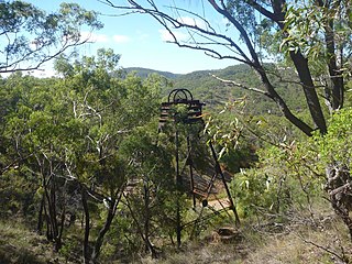
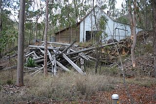
Vulcan Mine is a heritage-listed former mine at Mareeba Mining District, Irvinebank, Shire of Mareeba, Queensland, Australia. It was built from c. 1889 to 1930s. It was added to the Queensland Heritage Register on 21 October 1992.

Kingsborough Battery

Kingsborough Battery is a heritage-listed mining building off the former East Street, Kingsborough, Thornborough, Shire of Mareeba, Queensland, Australia. It was built from c. 1896 to 1990s. It was added to the Queensland Heritage Register on 21 October 1992.

Tyrconnel Mine and Battery

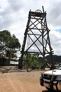
Tyrconnel Mine and Battery is a heritage-listed mine between Kingsborough and Thornborough, Shire of Mareeba, Queensland, Australia. It was built from 1876 to 1980s. It was added to the Queensland Heritage Register on 21 October 1992.

Day Dawn mine remains, Charters Towers

Day Dawn mine remains is a heritage-listed mine ruins at Paull Street, Charters Towers, Charters Towers Region, Queensland, Australia. It was built from 1891 to 1913. It was added to the Queensland Heritage Register on 29 April 2003.

Aspasia Mine and Battery

Aspasia Mine and Battery is a heritage-listed mine and stamper battery at Gulf Developmental Road, Georgetown, Shire of Etheridge, Queensland, Australia. It was built from 1916 to 1952. It is also known as Mount Turner Battery. It was added to the Queensland Heritage Register on 13 April 2006.

Joseph Morris Mine mine in Australia

Joseph Morris Mine is a heritage-listed former mine at Georgetown Mining District, Gilberton, Shire of Etheridge, Queensland, Australia. It was built from 1903 to 1910. It was added to the Queensland Heritage Register on 5 April 2004.

Content Mine former mine near Croydon, Queensland, Australia

Content Mine is a heritage-listed former mine at Gulf Developmental Road, Croydon, Shire of Croydon, Queensland, Australia. It was built from 1887 to 1918. It is also known as Content Block Mine. It was added to the Queensland Heritage Register on 4 July 2006.

Homeward Bound Battery and Dam dam in Australia

Homeward Bound Battery and Dam is a heritage-listed stamping mill and reservoir at Croydon, Shire of Croydon, Queensland, Australia. It was built in 1888 by Mr Schumacher. It was added to the Queensland Heritage Register on 21 October 1992.

Richmond Mine and Battery

Richmond Mine and Battery is a heritage-listed mine at Gulf Developmental Road, Croydon, Shire of Croydon, Queensland, Australia. It operated from 1886 to c. 1916. It was added to the Queensland Heritage Register on 28 July 2006.

Golden Gate Mining and Town Complex

Golden Gate Mining and Town Complex is a heritage-listed mining camp at Normanton Road, Croydon, Shire of Croydon, Queensland, Australia. It commenced in 1886. It is also known as Golden Gate Township, Croydon Consols Pump Shaft, Golden Gate No.10 North Mine, Golden Gate Cemetery, Croydon Consols Battery and Cyanide Plant, and Golden Gate Mine. It was added to the Queensland Heritage Register on 14 August 2009.

Mount Isa Mine Early Infrastructure

Mount Isa Mine Early Infrastructure is a heritage-listed group of mining infrastructure on the Mount Isa Mine Lease, Mount Isa, City of Mount Isa, Queensland, Australia. They comprise the Lawlor Shaft & Winding Plant, the Urquhart Shaft and Headframe, the Mount Isa Mine Experimental Dam, and the Mount Isa Mine Power Station. They were built from 1924 to c. 1963. They were added to the Queensland Heritage Register on 25 February 2005.

References

  1. 1 2 3 4 5 6 7 8 9 10 11 12 13 14 "General Grant Mine and Winding Plant (entry 600683)". Queensland Heritage Register . Queensland Heritage Council. Retrieved 1 August 2014.

Attribution

CC-BY-icon-80x15.png This Wikipedia article was originally based on "The Queensland heritage register" published by the State of Queensland under CC-BY 3.0 AU licence (accessed on 7 July 2014, archived on 8 October 2014). The geo-coordinates were originally computed from the "Queensland heritage register boundaries" published by the State of Queensland under CC-BY 3.0 AU licence (accessed on 5 September 2014, archived on 15 October 2014).

Commons-logo.svg Media related to General Grant Mine at Wikimedia Commons