Related Research Articles
Lawrence County is a county located in the U.S. state of Mississippi. As of the 2010 census, the population was 12,929. Its county seat is Monticello. The county is named for the naval hero James Lawrence.

Weston is a master-planned suburban city in Broward County, Florida, United States. It is located 31 miles northwest of Miami. The population was 65,333 at the 2010 census.

South Euclid is a city in Cuyahoga County, Ohio, United States. It is an inner-ring suburb of Cleveland located on the city's east side. As of the 2010 census the population was 22,295.

Elizabeth City is a city in Pasquotank County, North Carolina, in the United States. As of the 2010 census, it had a population of 18,683. Elizabeth City is the county seat and largest city of Pasquotank County. It is the cultural, economic and educational hub of the sixteen-county Historic Albemarle region of northeastern North Carolina.
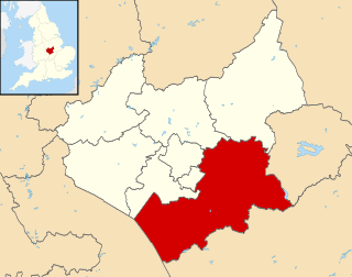
Harborough is a local government district of Leicestershire, England, named after its main town, Market Harborough. Covering 230 square miles (600 km2), the district is by far the largest of the eight district authorities in Leicestershire and covers almost a quarter of the county.
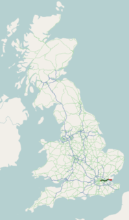
The A13 is a major road in England linking Central London with east London and south Essex. Its route is similar to that of the London, Tilbury and Southend line via Rainham, Grays, Tilbury & Stanford-Le-Hope, and runs the entire length of the northern Thames Gateway area, terminating on the Thames Estuary at Shoeburyness. It is a trunk road between London and the Tilbury junction, a primary route between there and Sadlers Hall Farm near South Benfleet, and a non-primary route between there and Shoeburyness.
Denbigh was a small unincorporated community in Warwick County, Virginia, USA, and was long the county seat. After a municipal consolidation in 1958, it became a neighborhood of the independent city of Newport News.
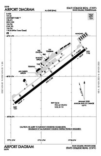
University Park Airport is a public airport in Benner Township, Centre County, Pennsylvania, serving State College and Bellefonte. UNV covers 1,091 acres and has one active runway.
Genuardi's Family Markets L.P. was a chain of supermarkets located in the Northeastern United States. Family-owned until purchased by Safeway in 2000, Genuardi's had its headquarters in the Bentwood Executive Campus in East Norriton Township, Pennsylvania in Greater Philadelphia.
Citation Boulevard, a four-lane divided highway, currently extends from just west of US 25 at the Norfolk Southern Railway to KY 922 in Lexington, Kentucky. Known as Phase I, it was completed in 2001 and included a bridge over Cane Run. Phase II extends southwest from the Norfolk Southern Railway to US 421 at Alexandria Drive and includes a span over the railroad. The highway west of Newtown Pike was constructed by the Kentucky Transportation Cabinet.
There are six middle schools in Arlington County, Virginia, administered by Arlington Public Schools.

The Louisiana Department of Transportation and Development (DOTD) is a state government organization in the United States, in charge of maintaining public transportation, roadways, bridges, canals, select levees, floodplain management, port facilities, commercial vehicles, and aviation which includes 69 airports, in the U.S. state of Louisiana. The agency has approximately five thousand personnel on staff and an operating budget of $2.3 billion. DOTD operations are run through nine district offices across the state.
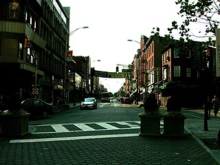
Harsimus is a neighborhood within Downtown Jersey City, Hudson County, New Jersey, United States. The neighborhood stretches from the Harsimus Stem Embankment on the north to Christopher Columbus Drive on the south between Coles Street and Grove Street or more broadly, to Marin Boulevard. It borders the neighborhoods of Hamilton Park to the north, Van Vorst Park to the south, the Village to the west, and the Powerhouse Arts District to the east. Newark Avenue has traditionally been its main street. The name is from the Lenape, used by the Hackensack Indians who inhabited the region and could be translated as Crow’s Marsh. From many years, the neighborhood was part of the "Horseshoe", a political delineation created by its position between the converging rail lines and political gerrymandering.
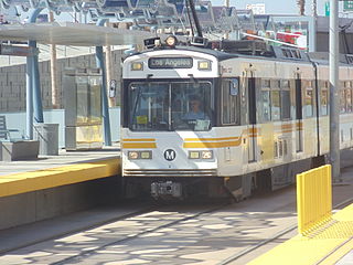
Jefferson/USC is an at-grade light rail station in the Los Angeles County Metro Rail system, located on Flower Street at Jefferson Boulevard, in the University Park in neighborhood of Los Angeles. This station is served by the E Line.

Expo/La Brea/ is an elevated light rail station in the Los Angeles County Metro Rail system. It is located at the intersection of La Brea Avenue and Exposition Boulevard, in the historic West Adams District of Los Angeles. This station is served by the E Line.

26th Street/Bergamot is an at-grade light rail station in the Los Angeles County Metro Rail system. It is located near the intersection of 26th Street and Olympic Boulevard in Santa Monica, California and near the Bergamot Station Arts Center. The station is served by the E Line.

Pemberton Heights is a neighborhood of Austin, Texas, and part of the Old West Austin Historic District. The area is bounded by Northwood Road on the north, Lamar Boulevard/Shoal Creek on the east, 24th Street/Windsor Road on the south, and Texas State Highway Loop 1 ("MoPac") on the west. It is Austin's wealthiest and most historic neighborhood.

Capitol Central, previously called the Negros Occidental Provincial Capitol Complex, is a government complex and mixed-use estate centered around the Negros Occidental Provincial Capitol, currently co-managed with Ayala Land. Certain portions are leased or sold to Ayala Land, as part of their industrial estate in Bacolod, Philippines.
References
- ↑ "Archived copy" (PDF). Archived from the original (PDF) on 2006-10-11. Retrieved 2007-11-27.CS1 maint: archived copy as title (link)
- ↑ [ permanent dead link ]
- ↑ "Home - Website". geneseevalleyregionalmarketauthority.com.
- ↑ "Archived copy". Archived from the original on 2009-01-16. Retrieved 2007-11-27.CS1 maint: archived copy as title (link)
- ↑ "Archived copy". Archived from the original on 2011-07-11. Retrieved 2007-11-27.CS1 maint: archived copy as title (link)
- ↑ Authority Leasing Area, (Map). Google Maps . Retrieved 2007-11-26.