Genga, Liberia

Last updated
Genga
Liberia location map.svg
Red pog.svg
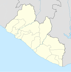
Genga
Location in Liberia
Coordinates: 8°22′37″N10°16′55″W / 8.37694°N 10.28194°W / 8.37694; -10.28194
Country Flag of Liberia.svg Liberia
County Lofa County
District Kolahun District

Genga is a village in northern Liberia. It is in the Kolahun District of Lofa County.

Liberia republic in West Africa

Liberia, officially the Republic of Liberia, is a country on the West African coast. It is bordered by Sierra Leone to its northwest, Guinea to its north, Ivory Coast to its east, and the Atlantic Ocean to its south-southwest. It covers an area of 111,369 square kilometers (43,000 sq mi) and has a population of around 4,700,000 people. English is the official language and over 20 indigenous languages are spoken, representing the numerous ethnic groups who make up more than 95% of the population. The country's capital and largest city is Monrovia.

Kolahun District

Kolahun District is the largest administrative district of Lofa County in Liberia. It has an estimated population of 59,057. Kolahun was the scene of heavy fighting between government troops and rebels during Liberia's second civil war, causing massive shifts in population and destruction of property.

Lofa County County in Voinjama, Liberia

Lofa is a county in the northernmost portion of Liberia. One of 15 counties that constitute the first-level of administrative division in the nation, it has nine districts. Voinjama serves as the capital with the area of the county measuring 9,982 square kilometres (3,854 sq mi). As of the 2008 Census, it had a population of 276,863, making it the third most populous county in Liberia.

To the west is the border with Sierra Leone, whilst the border with Guinea is to the north. Mount Wuteve is 40 km to the SE.

Sierra Leone republic in West Africa

Sierra Leone, officially the Republic of Sierra Leone, informally Salone, is a country on the southwest coast of West Africa. It has a tropical climate, with a diverse environment ranging from savanna to rainforests. The country has a total area of 71,740 km2 (27,699 sq mi) and a population of 7,075,641 as of the 2015 census. Sierra Leone is a constitutional republic with a directly elected president and a unicameral legislature. The country's capital and largest city is Freetown. Sierra Leone is made up of five administrative regions: the Northern Province, North West Province, Eastern Province, Southern Province and the Western Area. These regions are subdivided into sixteen districts.

Guinea country in Africa

Guinea, officially the Republic of Guinea, is a west-coastal country in West Africa. Formerly known as French Guinea, the modern country is sometimes referred to as Guinea-Conakry in order to distinguish it from other countries with "Guinea" in the name and the eponymous region, such as Guinea-Bissau and Equatorial Guinea. Guinea has a population of 12.4 million and an area of 245,860 square kilometres (94,927 sq mi).

Mount Wuteve mountain in Liberia

Mount Wuteve is a mountain located in Liberia, whose summit is the highest point in Liberia. It is located in the Guinea Highlands range, whose parent range is the West Africa Mountains. Data from the Shuttle Radar Topography Mission reveals that the correct elevation of its summit is 1,440 meters, and not the previously quoted 1,380 meters. It is also known as Mount Wologizi among locals of the Loma tribe.

Genga lies in a valley at an altitude of 432 meters, Lat 8°22'37"N, Long 10°16'55"W.

An alternate name is Geinga. [1]

Related Research Articles

Wayan is a small unincorporated community, located 35 miles north of Soda Springs in Caribou County, Idaho, United States. Located on State Highway 34, it is part of a valley known as Grays Lake, and its zip code is 83285. Wayan is located at 42.978 N and 111.376 W. The community was named after its first post master and his wife.

Sarris Candies

Sarris Candies, Inc., is a specialty chocolate and candies company based in Canonsburg, Pennsylvania, approximately 18 miles (29 km) southwest of Pittsburgh. It was founded in 1960 by Frank Sarris.

Lamont, Florida Census-designated place in Florida, United States

Lamont is an unincorporated community and census-designated place (CDP) in Jefferson County, Florida, United States. As of the 2010 census the population was 178.

Ntungamo Place in Uganda

Ntungamo is a town in the Western Region of Uganda. It is the largest town in Ntungamo District and the site of the district headquarters. It is the hometown of longtime President Yoweri Museveni.

Quiraing mountain in the United Kingdom

The Quiraing is a landslip on the eastern face of Meall na Suiramach, the northernmost summit of the Trotternish on the Isle of Skye, Scotland. The whole of the Trotternish Ridge escarpment was formed by a great series of landslips; the Quiraing is the only part of the slip still moving—the road at its base, near Flodigarry, requires repairs each year.

Stade Bergeyre

Stade Bergeyre is a former sports stadium in northeast of Paris, France, located in 19th district of the French capital. Built in August 1918, with financial support of Jacques Sigrand. Its capacity was approximately 15,000, and the name comes from the name of a French rugby player, who died in First World War.

Carneiros is a municipality located in the western of the Brazilian state of Alagoas. Its population is 9.182 (2014) and its area is 113 km².

KRXO (AM)

KRXO is a commercial AM radio station licensed to Claremore, Oklahoma, and serving the Tulsa metropolitan area. KRXO is owned by Ty and Tony Tyler, through licensee Tyler Media, LLC. It airs a sports radio format simulcast from co-owned KRXO-FM in Oklahoma City, with NBC Sports Radio programming late nights and weekends. Programming on KRXO (AM) is also broadcast on FM translator station K300CY at 107.9 MHz. The transmitter is off South 4100 Road in Claremore.

Henry Township, Marshall County, Illinois Township in Illinois, United States

Henry Township is located in Marshall County, Illinois. As of the 2010 census, its population was 2,700 and it contained 1,227 housing units.

Slatina is a district located in the eastern parts of the capital Sofia. As of 2006 it has 65,772 inhabitants. The district has an area of 13.25 km² which counts for 6.69% of the total Capital Municipality area. It is a flat country with some heights to the west.

Hercules Transit Center

Hercules Transit Center is a major commuter hub in the western Contra Costa County city of Hercules, California. It is anchored by WestCAT bus services. The center was originally on San Pablo Avenue. In August 2009, the transit center was relocated to the other side of I-80 with additional paid parking.

Turners Crossroads is an Unincorporated community in Northampton County, North Carolina, east-northeast of Margarettsville, North Carolina.

Jeleń, Kuyavian-Pomeranian Voivodeship Village in Kuyavian-Pomeranian, Poland

Jeleń is a village in the administrative district of Gmina Więcbork, within Sępólno County, Kuyavian-Pomeranian Voivodeship, in north-central Poland. It lies approximately 9 kilometres (6 mi) north-west of Więcbork, 13 km (8 mi) south-west of Sępólno Krajeńskie, and 52 km (32 mi) north-west of Bydgoszcz.

Anderson Township is a civil township in Barnes County, North Dakota, USA. As of the 2000 census, its population was 56.

Rural Municipality of Thompson rural municipality in Manitoba, Canada

Thompson is a rural municipality in the Pembina Valley Region of Manitoba, Canada. It had a population of 1,259 according to the Canada 2006 Census.

Peters Brook (Stony Brook tributary) river in the United States of America

Peters Brook is a tributary of Stony Brook in Mercer and Hunterdon counties, New Jersey in the United States.

Monroe Corner is an unincorporated community in Caroline County, in the U.S. state of Virginia.

Hirschberg (Allgäu) is a mountain of Bavaria, Germany.

Crab is an unincorporated community in Gloucester County, in the U. S. state of Virginia.

References

Coordinates: 8°22′37″N10°15′55″W / 8.37694°N 10.26528°W / 8.37694; -10.26528

Geographic coordinate system Coordinate system

A geographic coordinate system is a coordinate system that enables every location on Earth to be specified by a set of numbers, letters or symbols. The coordinates are often chosen such that one of the numbers represents a vertical position and two or three of the numbers represent a horizontal position; alternatively, a geographic position may be expressed in a combined three-dimensional Cartesian vector. A common choice of coordinates is latitude, longitude and elevation. To specify a location on a plane requires a map projection.