
Hipparchus was a Greek astronomer, geographer, and mathematician. He is considered the founder of trigonometry, but is most famous for his incidental discovery of precession of the equinoxes. Hipparchus was born in Nicaea, Bithynia, and probably died on the island of Rhodes, Greece. He is known to have been a working astronomer between 162 and 127 BC.

Eratosthenes of Cyrene was a Greek polymath: a mathematician, geographer, poet, astronomer, and music theorist. He was a man of learning, becoming the chief librarian at the Library of Alexandria. His work is comparable to what is now known as the study of geography, and he introduced some of the terminology still used today.
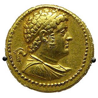
Ptolemy IV Philopator was the fourth pharaoh of Ptolemaic Egypt from 221 to 204 BC.

The Sicambri, also known as the Sugambri or Sicambrians, were a Germanic people who during Roman times lived on the east bank of the river Rhine, in what is now Germany, near the border with the Netherlands. They were first reported by Julius Caesar, who described them as Germanic (Germani), though he did not necessarily define this in terms of language.
The Volcae were a Gallic tribal confederation constituted before the raid of combined Gauls that invaded Macedonia c. 270 BC and fought the assembled Greeks at the Battle of Thermopylae in 279 BC. Tribes known by the name Volcae were found simultaneously in southern Gaul, Moravia, the Ebro valley of the Iberian Peninsula, and Galatia in Anatolia. The Volcae appear to have been part of the late La Tène material culture, and a Celtic identity has been attributed to the Volcae, based on mentions in Greek and Latin sources as well as onomastic evidence. Driven by highly mobile groups operating outside the tribal system and comprising diverse elements, the Volcae were one of the new ethnic entities formed during the Celtic military expansion at the beginning of the 3rd century BC. Collecting in the famous excursion into the Balkans, ostensibly, from the Greek point of view, to raid Delphi, a branch of the Volcae split from the main group on the way into the Balkans and joined two other tribes, the Tolistobogii and the Trocmi, to settle in central Anatolia and establish a new identity as the Galatians.
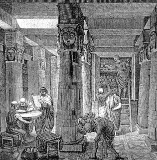
The Musaeum or Mouseion at Alexandria, which included the famous Library of Alexandria, was an institution said to have been founded by Ptolemy I Soter and his son Ptolemy II Philadelphus. Originally, the word mouseion meant any place that was dedicated to the Muses, often related to the study of music or poetry, but later associated with sites of learning such as Plato's Academy and Aristotle's Lyceum.

The history of geography includes many histories of geography which have differed over time and between different cultural and political groups. In more recent developments, geography has become a distinct academic discipline. 'Geography' derives from the Greek γεωγραφία – geographia, literally "Earth-writing", that is, description or writing about the Earth. The first person to use the word geography was Eratosthenes. However, there is evidence for recognizable practices of geography, such as cartography (map-making), prior to the use of the term.

Coele-Syria alternatively Coelo-Syria or Coelosyria, was a region of Syria in classical antiquity. It probably derived from the Aramaic word for all of the region of Syria, but it was most often applied to the Beqaa Valley between the Lebanon and the Anti-Lebanon mountain ranges. The area is now part of the modern-day Syria and Lebanon.
Antiochia Lamotis, Antiochia in Isauria, or Antiochia super Cragum is a Hellenistic city in ancient Cilicia, Anatolia at the mouth of Lamos river. The site is on the coast a few km southwest of Erdemli, Mersin Province, Turkey.

Aria was an Achaemenid region centered on the city of Herat in present-day western Afghanistan. In classical sources, Aria has been several times confused with the greater region of ancient Ariana, of which Aria formed a part.
Seleucis of Syria was a region of the Seleucid Empire located in northern Syria. It was also known as the Syrian Tetrapolis,
on account of its four most important cities, for it had many. These four were, Antioch, Seleuceia in Pieria, Apameia, and Laodiceia. It also comprehended, according to Strabo, four satrapies; and it is clear that he uses the name in a much wider sense than Ptolemy, who places the four cities of the tetrapolis of Strabo's Seleucis in so many separate districts; Antioch in Cassiotis, Apameia in Apamene, Laodiceia in Laodicene, while he only implies, but does not state, that Seleuceia lies in Seleucis."
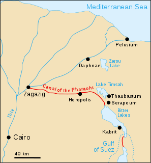
The Canal of the Pharaohs, also called the Ancient Suez Canal or Necho's Canal, is the forerunner of the Suez Canal, constructed in ancient times and kept in use, with intermissions, until being closed for good in 767 AD for strategic reasons during a rebellion. It followed a different course from its modern counterpart, by linking the Nile to the Red Sea via the Wadi Tumilat. Work began under the pharaohs. According to Darius the Great's Suez Inscriptions and Herodotus, the first opening of the canal was under Persian king Darius the Great, but later ancient authors like Aristotle, Strabo, and Pliny the Elder claim that he failed to complete the work. Another possibility is that it was finished in the Ptolemaic period under Ptolemy II, when engineers solved the problem of overcoming the difference in height through canal locks.
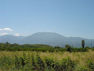
The Vermio Mountains, known in antiquity as the Bermion, is a mountain range in northern Greece. It lies between the Imathia Regional Unit of the Central Macedonia Region and the Kozani Regional Unit of the Western Macedonia Region. The range is west of the plain of Kambania. The town of Veria, which is the capital of Imathia, is built on the foot of these mountains. The highest point in the range is the peak Chamiti, 2,065 metres (6,775 ft) elevation, west of Naousa. In Turkish the mountain is known as Karatash (Karataş), and in Bulgarian it is known as Karakamen (Каракамен).
According to Strabo, the Artabri were an ancient Gallaecian Celtic tribe, living in the extreme north-west of modern Galicia, about Cape Nerium, outskirts of the city and port of Ferrol, where in Roman times, in the 1st century BC, a fishing port existed which also trade in metals as well as wild horses in the bay of Ferrol most likely administered from nearby Nerium in an area dominated by the Artabri ) giving name to the Portus Magnus Artabrorum. Strabo reports several seaports among the Artabri. Ptolemy places them among Galaeci Lucenses and gives their capital town as Lucus Augusti.
The Manimi were a Germanic tribe. They were mentioned by Tacitus, in his ethnographic book Germania, where he stated that the Manimi were one of the five most powerful tribes of the Lugii. They lived between the Oder and the Vistula.
Canae was, in classical antiquity, a city in ancient Aeolis, on the island of Argennusa in the Aegean Sea off the modern Dikili Peninsula on the coast of modern-day Turkey, near the modern village of Bademli. Today Argennusa has joined the mainland as the Kane Promontory off the Dikili Peninsula. Canae is famous as the site of the Battle of Arginusae in 406 B.C.
Olbia was the westernmost town on the coast of ancient Pamphylia, which some ancient writers place in Lycia. Ptolemy places it between Phaselis and Attaleia. Stephanus of Byzantium blames Philo for ascribing this town to Pamphylia, since, as he asserts, it was situated in the territory of the Solymi, and its real name was Olba; but the critic is here himself at fault, confounding Olbia with the Pisidian Olbasa. Strabo describes Olbia as a strong fortress, and its inhabitants colonised the Lycian town of Cadrema.
Heracleium or Herakleion, also known as Lamyron, was a port town of ancient Pontus, on the Black Sea, between Amisus and Polemonium. It was situated on a promontory of the same name.
Pordoselene or Poroselene (Ποροσελήνη) was a town and polis (city-state) of ancient Aeolis. It was located on the chief island of the Hecatonnesi, a group of small islands lying between Lesbos and the coast of Asia Minor, which was also called Prodoselene. Strabo says that some, in order to avoid the dirty allusion presented by this name, as pordos means fart in Greek, called it Poroselene, which is the form employed by Ptolemy, Pliny the Elder, and Aelian. At a still later time the name was changed into Proselene, under which form the town appears as a bishop's see. Aristotle mentions the town in his History of Animals where it was on the extremity of a road that formed the border between an area of the island that contained weasels and another area that did not have them.
Ischopolis (Ἰσχόπολις) was a city in ancient Pontus. It was near Pharnacia, and was in ruins even in the time of Strabo, but is still noticed by Ptolemy.