Geological compass

Last updated
Classic geological compass (Brunton), sideview Brujula Brunton 01.jpg
Classic geological compass (Brunton), sideview
Classic geological compass (Brunton), topview Brujula Brunton 02.jpg
Classic geological compass (Brunton), topview

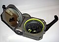
There are a number of different specialized magnetic compasses used by geologists to measure orientation of geological structures, as they map in the field, to analyze and document the geometry of bedding planes, joints, and/or metamorphic foliations and lineations. [1] [2] In this aspect the most common device used to date is the analogue compass.

Contents

Classic geological compasses

Classic geological compasses that are of practical use combine two functions, direction finding and navigation (especially in remote areas), and the ability to measure strike and dip of bedding surfaces and/or metamorphic foliation planes. Structural geologists (i.e. those concerned with geometry and the pattern of relative movement) also have a need to measure the plunge and plunge direction of lineations.

Compasses in common use include the Brunton compass and the Silva compass.

Modern geological compasses

The concept of modern geological compass was developed by Eberhard Clar of the University of Vienna during his work as structural geologist, which he published it in 1954. [3] An advantage of his concept is that strike and dip is measured in one step, using the vertical circle for dip angle and the compass for the strike direction. The first implementation was by the VEB Freiberger Präzisionsmechanik in Freiberg, Germany. The details of the design were made in a close cooperation with the Freiberg University of Mining and Technology. [4] In 2016 Brunton Inc. introduced the Axis Pocket Transit which, for the first time, offered simultaneous measurements of both strike and dip and trend and plunge in a variety of configurations. It featured an unconventional lid design that swung a full 360 degrees in both directions and two axes that allow precise measurement of vertical and horizontal angles on all configurations of bedding surfaces.

Usage

Strike line and dip of a plane describing attitude relative to a horizontal plane and a vertical plane perpendicular to the strike line StrikeLine&Dip.JPG
Strike line and dip of a plane describing attitude relative to a horizontal plane and a vertical plane perpendicular to the strike line

Geological compasses are distinctive because of the anti-clockwise direction of the numbers on the compass dial. This is because the compass is used to determine dip and dip-direction of surfaces (foliations), and plunge and plunge-direction of lines (lineations). To use the compass one aligns the lid of the compass with the orientation of the surface to be measured (to obtain dip and dip direction), or the edge of the lid of the compass with the orientation of the line (to obtain plunge and plunge direction). The compass must be twisted so that the base of the compass becomes horizontal, as accomplished using the spirit level incorporated in it. The needle of the compass is then freed by using the side button, and allowed to spin until the damping action slows its movement, and then stabilises. The side button is released and the needle is then firmly held in place, allowing the user thereafter to conveniently read the orientation measured. One first reads the scale that shows the angle subtended by the lid of the compass, and then depending on the colour shown (red or black) the end of the compass needle with the corresponding colour. Data are then recorded as (for example) 25°->333° (dip and dip-direction) or (plunge and plunge-direction).

This compass has the most use by structural geologists, measuring foliation and lineation in metamorphic rocks, or faults and joints in mining areas.

Digital compasses

With the advent of the smartphone, geological compass programs based on the 3-axis teslameter and the 3-axis accelerometer have also begun to appear. These compass programs use vector algebra to compute plane and lineation orientations from the accelerometer and magnetometer data, and permit rapid collection of many measurements. However, some problems are potentially present. Measurements made by smartphone geological compasses can potentially be susceptible to noise, mainly due to vibration or rapid hand movement. Users of a smartphone compass should carefully calibrate their devices and run several tests against traditional magnetic compasses in order to understand the limitations of their chosen program.

With traditional compasses there is no record of error caused by poor damping or operator movement. This limitation is removed by use of a digital compass, though these may be more error prone because of the sensitivity of the accelerometer, which programs use to determine vertical and horizontal. Therefore, professional use of a digital geological compass requires the recoding of variance in individual measurements. There is no data that suggests digital compasses are subject to any measurable form of magnetic disturbance.

Modern remote sensing techniques as LiDAR and photogrammetry allow to obtain accurate and dense 3D point clouds. These point clouds allow the measurement of orientations of planar surfaces. Jordá et al. [5] performed a comparison of the orientations of discontinuities measured by means of classical geological compass and a photogrammetric 3D point cloud demonstrating that remote sensing field discontinuity collection provides a reliable alternative to the use of geological compass.

Related Research Articles

<span class="mw-page-title-main">Structural geology</span> Science of the description and interpretation of deformation in the Earths crust

Structural geology is the study of the three-dimensional distribution of rock units with respect to their deformational histories. The primary goal of structural geology is to use measurements of present-day rock geometries to uncover information about the history of deformation (strain) in the rocks, and ultimately, to understand the stress field that resulted in the observed strain and geometries. This understanding of the dynamics of the stress field can be linked to important events in the geologic past; a common goal is to understand the structural evolution of a particular area with respect to regionally widespread patterns of rock deformation due to plate tectonics.

<span class="mw-page-title-main">Compass</span> Instrument used for navigation and orientation

A compass is a device that shows the cardinal directions used for navigation and geographic orientation. It commonly consists of a magnetized needle or other element, such as a compass card or compass rose, which can pivot to align itself with magnetic north. Other methods may be used, including gyroscopes, magnetometers, and GPS receivers.

<span class="mw-page-title-main">Geophysics</span> Physics of the Earth and its vicinity

Geophysics is a subject of natural science concerned with the physical processes and physical properties of the Earth and its surrounding space environment, and the use of quantitative methods for their analysis. Geophysicists, who usually study geophysics, physics, or one of the Earth sciences at the graduate level, complete investigations across a wide range of scientific disciplines. The term geophysics classically refers to solid earth applications: Earth's shape; its gravitational, magnetic fields, and electromagnetic fields ; its internal structure and composition; its dynamics and their surface expression in plate tectonics, the generation of magmas, volcanism and rock formation. However, modern geophysics organizations and pure scientists use a broader definition that includes the water cycle including snow and ice; fluid dynamics of the oceans and the atmosphere; electricity and magnetism in the ionosphere and magnetosphere and solar-terrestrial physics; and analogous problems associated with the Moon and other planets.

<span class="mw-page-title-main">Magnetometer</span> Device that measures magnetism

A magnetometer is a device that measures magnetic field or magnetic dipole moment. Different types of magnetometers measure the direction, strength, or relative change of a magnetic field at a particular location. A compass is one such device, one that measures the direction of an ambient magnetic field, in this case, the Earth's magnetic field. Other magnetometers measure the magnetic dipole moment of a magnetic material such as a ferromagnet, for example by recording the effect of this magnetic dipole on the induced current in a coil.

<span class="mw-page-title-main">Geologic map</span> Special-purpose map to show geological features

A geologic map or geological map is a special-purpose map made to show various geological features. Rock units or geologic strata are shown by color or symbols. Bedding planes and structural features such as faults, folds, are shown with strike and dip or trend and plunge symbols which give three-dimensional orientations features.

<span class="mw-page-title-main">Fold (geology)</span> Stack of originally planar surfaces

In structural geology, a fold is a stack of originally planar surfaces, such as sedimentary strata, that are bent or curved ("folded") during permanent deformation. Folds in rocks vary in size from microscopic crinkles to mountain-sized folds. They occur as single isolated folds or in periodic sets. Synsedimentary folds are those formed during sedimentary deposition.

<span class="mw-page-title-main">Inclinometer</span> Instrument used to measure the inclination of a surface relative to local gravity

An inclinometer or clinometer is an instrument used for measuring angles of slope, elevation, or depression of an object with respect to gravity's direction. It is also known as a tilt indicator, tilt sensor, tilt meter, slope alert, slope gauge, gradient meter, gradiometer, level gauge, level meter, declinometer, and pitch & roll indicator. Clinometers measure both inclines and declines using three different units of measure: degrees, percentage points, and topos. The astrolabe is an example of an inclinometer that was used for celestial navigation and location of astronomical objects from ancient times to the Renaissance.

<span class="mw-page-title-main">Orientation (geometry)</span> Notion of pointing in a direction

In geometry, the orientation, attitude, bearing, direction, or angular position of an object – such as a line, plane or rigid body – is part of the description of how it is placed in the space it occupies. More specifically, it refers to the imaginary rotation that is needed to move the object from a reference placement to its current placement. A rotation may not be enough to reach the current placement, in which case it may be necessary to add an imaginary translation to change the object's position. The position and orientation together fully describe how the object is placed in space. The above-mentioned imaginary rotation and translation may be thought to occur in any order, as the orientation of an object does not change when it translates, and its position does not change when it rotates.

<span class="mw-page-title-main">Foliation (geology)</span> Repetitive layering in metamorphic rocks

Foliation in geology refers to repetitive layering in metamorphic rocks. Each layer can be as thin as a sheet of paper, or over a meter in thickness. The word comes from the Latin folium, meaning "leaf", and refers to the sheet-like planar structure. It is caused by shearing forces, or differential pressure. The layers form parallel to the direction of the shear, or perpendicular to the direction of higher pressure. Nonfoliated metamorphic rocks are typically formed in the absence of significant differential pressure or shear. Foliation is common in rocks affected by the regional metamorphic compression typical of areas of mountain belt formation.

<span class="mw-page-title-main">Strike and dip</span> Orientation of a geologic feature

In geology, strike and dip is a measurement convention used to describe the plane orientation or attitude of a planar geologic feature. A feature's strike is the azimuth of an imagined horizontal line across the plane, and its dip is the angle of inclination measured downward from horizontal. They are used together to measure and document a structure's characteristics for study or for use on a geologic map. A feature's orientation can also be represented by dip and dip direction, using the azimuth of the dip rather than the strike value. Linear features are similarly measured with trend and plunge, where "trend" is analogous to dip direction and "plunge" is the dip angle.

<span class="mw-page-title-main">Brunton compass</span> Precision compass made by Brunton, Inc. of Riverton, Wyoming

A Brunton compass, properly known as the Brunton Pocket Transit, is a precision compass made by Brunton, Inc. of Riverton, Wyoming. The instrument was patented in 1894 by Canadian-born geologist David W. Brunton. Unlike most modern compasses, the Brunton Pocket Transit utilizes magnetic induction damping rather than fluid to damp needle oscillation. Although Brunton, Inc. makes many other types of magnetic compasses, the Brunton Pocket Transit is a specialized instrument used widely by those needing to make accurate navigational and slope-angle measurements in the field. Users are primarily geologists, but archaeologists, environmental engineers, mining engineers and surveyors also make use of the Brunton's capabilities. The United States Army has adopted the Pocket Transit as the M2 Compass for use by crew-served artillery.

Lineations in structural geology are linear structural features within rocks. There are several types of lineations, intersection lineations, crenulation lineations, mineral lineations and stretching lineations being the most common. Lineation field measurements are recorded as map lines with a plunge angle and azimuth.

<span class="mw-page-title-main">Diver navigation</span> Underwater navigation by scuba divers

Diver navigation, termed "underwater navigation" by scuba divers, is a set of techniques—including observing natural features, the use of a compass, and surface observations—that divers use to navigate underwater. Free-divers do not spend enough time underwater for navigation to be important, and surface supplied divers are limited in the distance they can travel by the length of their umbilicals and are usually directed from the surface control point. On those occasions when they need to navigate they can use the same methods used by scuba divers.

<span class="mw-page-title-main">Vergence (geology)</span>

In structural geology, vergence refers to the direction of the overturned component of an asymmetric fold. In simpler terms, vergence can be described as the horizontal direction in which the upper-component of rotation is directed. Vergence can be observed and recorded in folds to help a geologist determine characteristics of larger fold areas. Vergence is used to provide an overall characterization, in the symmetry of folds, and can be used to observe changes in small-scale structures in relation to the axis of a large fold. The vergence of a fold lies parallel to the surrounding surfaces of a fold, so if these surrounding surfaces are not horizontal in nature, the vergence of the fold will be inclined. For a fold, the direction, as well as the extent to which vergence occurs, can be calculated from the strike and dip of the axial surfaces, along with that of the enveloping surfaces. These calculations can be very useful for geologists in determining the overall elements of larger areas.

<span class="mw-page-title-main">Texture (geology)</span>

In geology, texture or rock microstructure refers to the relationship between the materials of which a rock is composed. The broadest textural classes are crystalline, fragmental, aphanitic, and glassy. The geometric aspects and relations amongst the component particles or crystals are referred to as the crystallographic texture or preferred orientation. Textures can be quantified in many ways. The most common parameter is the crystal size distribution. This creates the physical appearance or character of a rock, such as grain size, shape, arrangement, and other properties, at both the visible and microscopic scale.

<span class="mw-page-title-main">Magnetic dip</span> Angle made with the horizontal by Earths magnetic field lines

Magnetic dip, dip angle, or magnetic inclination is the angle made with the horizontal by Earth's magnetic field lines. This angle varies at different points on Earth's surface. Positive values of inclination indicate that the magnetic field of Earth is pointing downward, into Earth, at the point of measurement, and negative values indicate that it is pointing upward. The dip angle is in principle the angle made by the needle of a vertically held compass, though in practice ordinary compass needles may be weighted against dip or may be unable to move freely in the correct plane. The value can be measured more reliably with a special instrument typically known as a dip circle.

<span class="mw-page-title-main">Brunton, Inc.</span>

Brunton Inc. is now Brunton International LLC after its recent acquisition in late 2021. They are a manufacturer of navigation tools including recreational compasses, navigational equipment, and geology and survey instruments. They are located in Riverton, Wyoming.

In structural geology, rake is formally defined as "the angle between a line [or a feature] and the strike line of the plane in which it is found", measured on the plane. The three-dimensional orientation of a line can be described with just a plunge and trend. The rake is a useful description of a line because often features (lines) follow along a planar surface. In these cases the rake can be used to describe the line's orientation in three dimensions relative to that planar surface. One might also expect to see this used when the particular line is hard to measure directly. The rake always sweeps down from the horizontal plane.

<span class="mw-page-title-main">History of geomagnetism</span> History of the study of Earths magnetic field

The history of geomagnetism is concerned with the history of the study of Earth's magnetic field. It encompasses the history of navigation using compasses, studies of the prehistoric magnetic field, and applications to plate tectonics.

Geological structure measurement by LiDAR technology is a remote sensing method applied in structural geology. It enables monitoring and characterisation of rock bodies. This method's typical use is to acquire high resolution structural and deformational data for identifying geological hazards risk, such as assessing rockfall risks or studying pre-earthquake deformation signs.

References

  1. The Mapping of Geological Structures (Geological Society of London Handbook Series) [Paperback] K. R. McClay
  2. Statistics of Earth Science Data: Their Distribution in Time, Space and Orientation [Paperback] Graham J. Borradaile (Author)
  3. Clar, E.: A dual-circle geologist’s and miner’s compass for the measurement of areal and linear geological elements Separate print from the negotiations of the Federal Institute of Geology Vienna, 1954, vol. 4
  4. "Archived copy" (PDF). Archived from the original (PDF) on 2015-01-20. Retrieved 2015-02-14.{{cite web}}: CS1 maint: archived copy as title (link)
  5. Jordá Bordehore, Luis; Riquelme, Adrian; Cano, Miguel; Tomás, Roberto (2017-09-01). "Comparing manual and remote sensing field discontinuity collection used in kinematic stability assessment of failed rock slopes". International Journal of Rock Mechanics and Mining Sciences. 97: 24–32. doi:10.1016/j.ijrmms.2017.06.004. hdl: 10045/67528 . ISSN   1365-1609.