
The Prešov Region, also Priashiv Region, is one of the eight Slovak administrative regions and consists of 13 districts (okresy) and 666 municipalities, 23 of which have town status. The region was established in 1996 and is the most populous of all the regions in Slovakia. Its administrative center is the city of Prešov.

The Beskids or Beskid Mountains are a series of mountain ranges in the Carpathians, stretching from the Czech Republic in the west along the border of Poland with Slovakia up to Ukraine in the east.

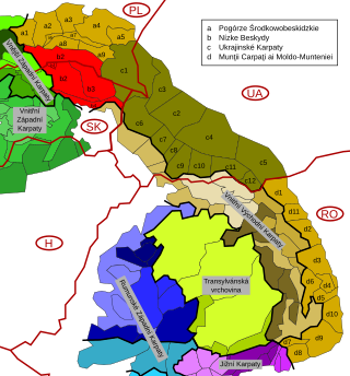
Divisions of the Carpathians are a categorization of the Carpathian mountains system.

The Žilina Region is one of the eight Slovak administrative regions and consists of 11 districts (okresy) and 315 municipalities, from which 18 have a town status. The region was established in 1923, however, in its present borders exists from 1996. It is a more industrial region with several large towns. Žilina is the region administrative center and there is a strong cultural environment in Martin.

The Slovak Ore Mountains are an extensive mountain range within the Carpathian Mountains, located mostly in Slovakia's Spiš and Gemer region, with a small part in northern Hungary. It is the largest mountain range in Slovakia. Geomorphologically, the Slovak Ore Mountains belong to the Inner Western Carpathians.

Malá Fatra is a mountain range in the Western Carpathians in the north-west of Central Slovakia. In the geomorphological system, it is a part of the Fatra-Tatra Area.

The Kremnica Mountains are a volcanic mountain range in central Slovakia. They are part of the Western Carpathians and the Slovenské stredohorie Mts.

The Štiavnica Mountains are a volcanic mountain range southern central Slovakia. They are part of Inner Western Carpathians and the Slovenské stredohorie Mountains. The area is protected by Štiavnica Mountains Protected Landscape Area.
The Strážov Mountains are a mountain range in northwestern Slovakia, being part of Inner Western Carpathians, and of the Fatra-Tatra Area. They are situated between the towns of Trenčín, Považská Bystrica, Rajec, Prievidza and Bánovce nad Bebravou, bordering White Carpathians and the Váh river in the northwest and west, Javorníky in the north, Malá Fatra in the east, Vtáčnik and Nitra river in the south and Považský Inovec in the southwest. The highest mountain is Strážov

The Slovak Central Mountains are a group of mountain ranges in southern central Slovakia. The town of Zvolen lies roughly in the centre of the mountains.
Protected areas of Slovakia are areas that need protection because of their environmental, historical or cultural value to the nation. Protected areas in Slovakia are managed by institutions and organizations governed by the Ministry of the Environment.

Horná Orava Protected Landscape Area is one of the 14 protected landscape areas in Slovakia. It is situated in the Námestovo and Tvrdošín districts, within the Orava region.
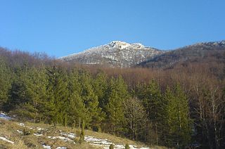
The Low Beskids or Central Beskids are a mountain range in southeastern Poland and northeastern Slovakia. They constitute a middle (central) section of the Beskids, within the Outer Eastern Carpathians.

The Western Carpathians are an arc-shaped mountain range, the northern branch of the Alpine-Himalayan fold and thrust system called the Alpide belt, which evolved during the Alpine orogeny. In particular, their pre-Cenozoic evolution is very similar to that of the Eastern Alps, and they constitute a transition between the Eastern Alps and the Eastern Carpathians.

The Western Beskids are a set of mountain ranges spanning the Czech Republic, Slovakia, and Poland. Geologically the Western Beskids are part of the Outer Western Carpathians.

The Slovak-Moravian Carpathians are the mountain ranges along the border of the Czech Republic and Slovakia. Before the Treaty of Trianon in 1920, it was known in Hungarian as Magyar-morva határhegység 'the Hungarian-Moravian border mountains'.

The Podhale-Magura Area — is a geomorphologic region of mountain ranges in northern Slovakia and southern Poland, belonging to the Outer Western Carpathians within the Carpathian Mountains system.
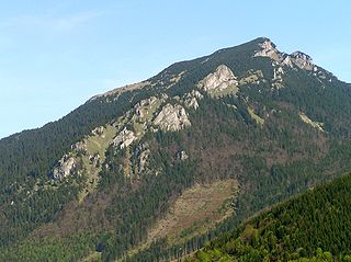
The Choč Mountains are a range of mountains in north-central Slovakia, a portion of the Fatra-Tatra Area of the Inner Western Carpathians. The range is 24 kilometers long and on average only 4 kilometers wide. Highest peak is Veľký Choč at 1 611 metres above sea level.

Central section of the Western Beskids are a set of mountain ranges spanning the southern Polish and northern Slovak border. They constitute a section of the Western Beskids, within the Outer Western Carpathians.

The Orava Highlands is a range of small mountains in the Žilina Region of north central Slovakia, part of the Outer Western Carpathians. In Slovakia these hills are considered part of the Central Beskids; in Poland they're considered Western Beskids.
This page is based on this
Wikipedia article Text is available under the
CC BY-SA 4.0 license; additional terms may apply.
Images, videos and audio are available under their respective licenses.
