A canyon, gorge or chasm, is a deep cleft between escarpments or cliffs resulting from weathering and the erosive activity of a river over geologic time scales. Rivers have a natural tendency to cut through underlying surfaces, eventually wearing away rock layers as sediments are removed downstream. A river bed will gradually reach a baseline elevation, which is the same elevation as the body of water into which the river drains. The processes of weathering and erosion will form canyons when the river's headwaters and estuary are at significantly different elevations, particularly through regions where softer rock layers are intermingled with harder layers more resistant to weathering.

The Dinaric Alps, also Dinarides, are a mountain range in Southern and Southcentral Europe, separating the continental Balkan Peninsula from the Adriatic Sea. They stretch from Italy in the northwest through Slovenia, Croatia, Bosnia and Herzegovina, Serbia, Montenegro, and Kosovo to Albania in the southeast.
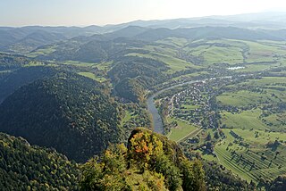
The Dunajec is a river running through northeastern Slovakia and southern Poland. It is also regarded as the main river of the Goral Lands. It is a right tributary of the Vistula River. It begins in Nowy Targ at the junction of two short mountain rivers, Czarny Dunajec and Biały Dunajec. Dunajec forms the border between Poland and Slovakia for 17 kilometres (11 mi) in the Pieniny Środkowe range, east of the Czorsztyn reservoir.

Pieniny National Park is a protected area located in the heart of the Pieniny mountains in the southernmost part of Poland. It is the oldest national park in Poland. Administratively, the park lies in the Lesser Poland Voivodeship on the border with Slovakia. Its head office is in Krościenko nad Dunajcem.

Pieniny National Park is a national park in northern Slovakia. The park is located in the eastern Pieniny Mountains on the border with Poland. It is the smallest national park in Slovakia with an area of 37.49 km2 (14.48 mi2) and a buffer zone of 224.44 km2 (86.66 mi2). The park is located in the Slovak districts of Kežmarok and Stará Ľubovňa in the Prešov Region.

Červený Kláštor is a small village and municipality in the far north Kežmarok District in the Prešov Region of northern Slovakia, near the Polish border, in the Zamagurie region.

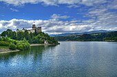
Czorsztyn is a village in Poland, in Lesser Poland Voivodeship, Nowy Targ County. The village lies in Pieniny, the mountain range on the current Polish-Slovak border. It is famous for the ruins of a 14th-17th-century castle, which was the scene of the Kostka-Napierski Uprising in 1651.
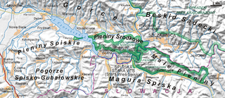
Zamagurie is a region in the Goral Lands area in the north of the Spiš region, between the Spišská Magura in the south, the Dunajec river in the north and the Białka river in the west. It is divided between the Prešov Region of Slovakia and the Lesser Poland Voivodeship of Poland and is further divided between the Slovak districts of Stará Ľubovňa and Kežmarok and Polish gminas of Bukowina Tatrzańska, Nowy Targ and Łapsze Niżne. The centre of the region is the Slovak town Spišská Stará Ves, which is just near the border. The region also used to be one of the official tourist regions of Slovakia until 2004.
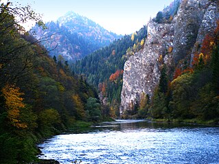
The Dunajec River Gorge runs through the Pieniny Mountains in the south of Poland and the north of Slovakia. The gorge is characterized by some of the most interesting geological and geomorphological structures and area-specific natural ecosystems with little anthropogenic influence. It is featured on UNESCO's Tentative List of World Heritage Sites in Poland.

Niedzica is a resort village in Nowy Targ County of Lesser Poland province, Poland, located on the banks of Lake Czorsztyn. It is famous for Niedzica Castle, also known as Dunajec Castle. It lies approximately 6 kilometres (4 mi) north-east of Łapsze Niżne, 21 km (13 mi) east of Nowy Targ, and 75 km (47 mi) south of the regional capital Kraków.

Niedzica Castle, also known as Dunajec Castle, is located in the southernmost part of Poland in Niedzica. It was erected between the years 1320 and 1326 by Kokos of Brezovica on the site of an ancient stronghold surrounded by earthen walls in the Pieniny mountains.

Krościenko nad Dunajcem is a village in southern Poland situated in the Nowy Targ County in Lesser Poland Voivodeship since 1999. Located near Poland's border with Slovakia, it is approximately 31 kilometres (19 mi) east of Nowy Targ and 78 km (48 mi) south-east of the regional capital Kraków. Town rights were given to Krościenko by Kazimierz Wielki in 1348.

The Pieniny Klippen Belt is in geology a tectonically and orographically remarkable zone in the Western Carpathians, with a very complex geological structure. It is a narrow and extremely long north banded zone of extreme shortening and sub-vertical strike-slip fault zone, with complex geological history, where only fragments of individual strata and facies are preserved. The Pieniny Klippen Belt is considered one of the main tectonic sutures of the Carpathians and forms the boundary between the Outer and Central Western Carpathians.

The Western Carpathians are an arc-shaped mountain range, the northern branch of the Alpine-Himalayan fold and thrust system called the Alpide belt, which evolved during the Alpine orogeny. In particular, their pre-Cenozoic evolution is very similar to that of the Eastern Alps, and they constitute a transition between the Eastern Alps and the Eastern Carpathians.
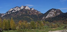
Trzy Korony is the summit of the Three Crowns Massif, an independent portion of a range called Pieniny Mountains in the south of Poland. Trzy Korony forms the central part of a compact group of connected mountains known as Pieniny Środkowe, consisting mainly of the limestone and dolomite rock strata. Trzy Korony is located within the Pieniny National Park in Lesser Poland Voivodeship.
The Dunajec river castles is a chain of thirteen medieval castles, built in southern Lesser Poland, along the Dunajec river. The castles protected the border between the Kingdom of Poland and the Kingdom of Hungary, as well as a very important international trade route, which went along the Dunajec and the Poprad all the way down to the Danube river. Most of the castles are in ruins now, and some have disappeared. Their history dates back to the period known as the Fragmentation of Poland in the early 12th century, when, according to his will, known as the Testament of Bolesław III Wrymouth, the country was divided into several provinces. The Dunajec river castles were located on the territory of two castellanies, Wojnicz and Nowy Sącz, in the extreme south of the Seniorate Province.

Beskid Sądecki is a mountain range in the eastern section of the Western Beskids, within the Outer Western Carpathians. It is located in the border region between Poland and Slovakia. On the Polish side, it stretches along an area of 670 km², between the Dunajec river in the west and the valleys of the Kamienica Nawojowska river, Mochnaczka, Muszynka, Przełęcz Tylicka in the east. The highest peak of the mountain range is Radziejowa at 1262 metres. The mountains are built from flysch rocks.

The Kotuńka Rock is a prominent rock found in the centre of the current of the river Dunajec just before the entry into Szczawnica. Built from limestone, the rock is well seen from the road and is a characteristic landmark in the area. Just above the rock the Grajcarek flows into the Dunajec. On from the rock is a bridge, after which begins the Pieniny Trail Road which heads to a border crossing.

The geology of Slovakia is structurally complex, with a highly varied array of mountain ranges and belts largely formed during the Alpine orogeny in Mesozoic and Cenozoic eras and with relicts of older Variscan structures of Paleozoic age. The internal zones of the West Carpathian orogen collapsed during Paleogene forming the Central Carpathian Paleogne Basin and later in Miocene the Pannonian Basin and Carpathian volcanic chain were formed.

The geology of Croatia has some Precambrian rocks mostly covered by younger sedimentary rocks and deformed or superimposed by tectonic activity.