
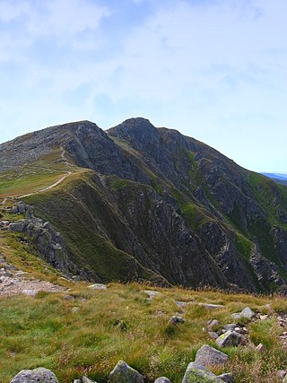
The Low Tatras or Low Tatra is a mountain range of the Inner Western Carpathians in central Slovakia.

Poprad is a city in northern Slovakia at the foot of the High Tatra Mountains, famous for its picturesque historic centre and as a holiday resort. It is the biggest town of the Spiš region and the tenth largest city in Slovakia, with a population of approximately 50,000.
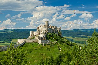
Spiš is a region in north-eastern Slovakia, with a very small area in south-eastern Poland. Spiš is an informal designation of the territory, but it is also the name of one of the 21 official tourism regions of Slovakia. The region is not an administrative division in its own right, but between the late 11th century and 1920 it was an administrative county of the Kingdom of Hungary.

The Prešov Region, also Priashiv Region, is one of the eight Slovak administrative regions and consists of 13 districts (okresy) and 666 municipalities, 23 of which have town status. The region was established in 1996 and is the most populous of all the regions in Slovakia. Its administrative center is the city of Prešov.

The High Tatras or High Tatra Mountains, are a mountain range along the border of northern Slovakia in the Prešov Region, and southern Poland in the Lesser Poland Voivodeship. They are a range of the Tatra Mountains chain.

The Lemko Region is an ethnographic area in southern Poland and Northern Eastern Slovakia that has traditionally been inhabited by the Lemko people. The land stretches approximately 140 km (87 mi) long and 25–50 km (16–31 mi) wide along the north side of the Carpathian Mountains, following the Polish-Slovak border from the Poprad River. In the East, the region is described as either terminating linguistically between the Wisłok River Wisłok and Osława Rivers, or ethnographically at the Sanok River, where it meets the Boyko region. Some even go so far as to consider it to extend south into the Prešov Region, Slovakia.

Štrbské Pleso is a ski, tourist, and health resort in the High Tatras, Slovakia located on the lake by the same name. With extensive parking facilities and a stop on the Tatra trolley and rack railway, it is a starting point for a host of popular hikes including to Kriváň and Rysy.
Kežmarok District is a district in the Prešov Region of eastern Slovakia. Its seat, cultural and economic center is Kežmarok, the traditional center of the historic Spiš region. The Kežmarok district was established in 1923 and exists in its present borders from 1996. Currently it consists of 42 municipalities, from which 3 have a town status. Main economic branches are industry and tourism. In the Kežmarok district Slovakia's top tourist attractions are located such as Pieniny National Park with easy access to the High Tatra Mountains. The district lies mainly on a foothills of High Tatras.
Poprad District is a district in the Prešov Region of eastern Slovakia. The district had been established in 1923 and from 1996 exists in its current borders. It consists of 29 municipalities, from which three have a town status. Its seat, cultural and economic center is Poprad, the largest city. Main economic branches are industry and tourism. In Poprad district is located mountain range High Tatras, top tourist attraction in Slovakia.

Jasná is a small village situated in central Slovakia, in the Low Tatras mountains. It is a part of the municipality Demänovská Dolina.

Starý Smokovec is a part of the town of Vysoké Tatry in northern Slovakia in the Tatras.

Tatra County is a unit of territorial administration and local government (powiat) in Lesser Poland Voivodeship, southern Poland, on the Slovak border. It came into being on January 1, 1999, as a result of the Polish local government reforms passed in 1998. Its administrative seat and only town is Zakopane, which lies 85 kilometres (53 mi) south of the regional capital Kraków. The county takes its name from the Tatra mountain range, which covers most of its territory.
Pavčina Lehota is a village and municipality in Liptovský Mikuláš District in the Žilina Region of northern Slovakia. The village is known mainly for tourism because of its location among the famous attractions of large caves, aqua parks, ski resorts that surrounds the village.
Low Tatras National Park is a national park in Central Slovakia, between the Váh River and the Hron River valleys. The park and its buffer zone cover the whole Low Tatras mountain range. The National Park covers an area of 728 km2 and its buffer zone covers an area of 1,102 km2, which makes it the largest national park in Slovakia.

The Podtatranská kotlina is a basin in northern Slovakia, part of the Fatra-Tatra Area, which belongs to the Inner Western Carpathians.

Poprad-Tatry railway station is a break-of-gauge junction station serving the city of Poprad, in the Prešov Region, northeastern Slovakia.
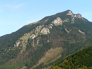
The Choč Mountains are a range of mountains in north-central Slovakia, a portion of the Fatra-Tatra Area of the Inner Western Carpathians. The range is 24 kilometers long and on average only 4 kilometers wide. Highest peak is Veľký Choč at 1 611 metres above sea level.

The Levoča Mountains is a mountain range in the Prešov Region of northern Slovakia. Geologically the range stands within the Podhale-Magura Area of the Outer Western Carpathians.
Nový Smokovec is a spa village in Poprad District, Slovakia. It is administratively a part of the town of Vysoké Tatry.

The Poland–Slovakia border is the international border between Poland and Slovakia and has formally existed since 1 January 1993, following the dissolution of Czechoslovakia into two independent states. Before the dissolution of Czechoslovakia, its eastern border with Poland was practically identical to the present day border between Poland and Slovakia, with minor corrections made in later years. The length of the Poland–Slovakia border is 541 kilometres (336 mi)