
The Greenbelt is a 203.5-square-kilometre (78.6 sq mi) protected green belt traversing Ottawa, Ontario, Canada. It includes green space, forests, farms, and wetlands from Shirleys Bay in the west and to Green's Creek in the east. It is the largest publicly owned green belt in the world and the most ecologically diverse area in Eastern Ontario. The National Capital Commission (NCC) owns and manages 149.5 square kilometres (57.7 sq mi), and the rest is held by other federal government departments and private interests. Real estate development within the Greenbelt is strictly controlled.

The current Ottawa City Hall is the city hall of Ottawa, Ontario, Canada. The downtown complex consists of two connected buildings: a modern wing located on Laurier Avenue and a 19th-century heritage wing located on Elgin Street. Although City Hall has frontage on two major streets, the main entrance is on Laurier Avenue, and the municipal address is 110 Laurier Avenue West.
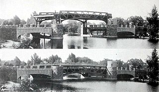
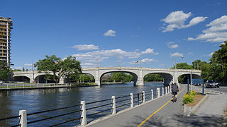
The Pretoria Bridge is a table bridge in Ottawa, Ontario, Canada. It crosses the Rideau Canal linking the Glebe and Centretown to Old Ottawa East. The bridge was built in 1915, replacing an earlier wooden swing bridge on Argyle Street just to the north. It is a table bridge, meaning that the central portion of the bridge can be elevated to allow boats to pass underneath. Although built by the Strauss Bascule Bridge Company, the moveable span is not a bascule type but a table-type.

Patterson Creek is a small body of water in the middle of Ottawa, Ontario. The creek was originally a small stream flowing east through a swampy area to the Rideau River. The construction of the Rideau Canal blocked the creek causing it to become much larger in size. Prior to the construction the land housed a Cedar Lodge. The construction created a small island in the creek that then housed the Cedar Lodge, but this structure was demolished in the 1930s. The Creek originally ran from near Lyon Street all the way to the canal. The creek was named after George Patterson, an early settler who owned the lot where the creek emptied into the canal. In the 1890s work began on landscaping the area. The western portion of the creek disappeared, replaced by Central Park in one of the first projects of the Ottawa Improvement Commission.
The Bank Street Bridge, officially known as the Bank Street Canal Bridge, is a bridge in Ottawa, Ontario, Canada, that carries Bank Street over the Rideau Canal. It links the Glebe to Old Ottawa South. It also passes over the Queen Elizabeth Driveway and Colonel By Drive.
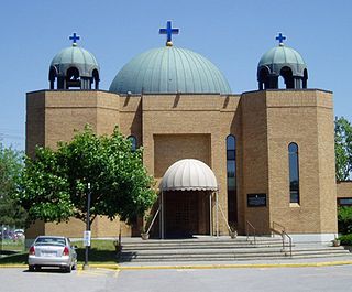
Saints Peter and Paul Melkite Catholic Church is a Melkite Greek Catholic Church in Ottawa, Ontario, Canada. It is located on 1161 North River Road in Overbrook, just to the east of the Rideau River.

Ottawa SuperEX was an eleven-day annual exhibition that took place every August at Lansdowne Park in Ottawa, Ontario. The exhibition provided exhibits, entertainment and amusements indoors in the buildings on site and outdoors on the grounds. The Central Canada Exhibition Association operated a fair annually from 1888 until 2010, except during World War II. The fair was on hiatus due to plans to redevelop Lansdowne Park and the Association continued to work towards finding opportunities to bring back SuperEX. It was announced in December 2015 that the Ottawa SuperEX board had disbanded a year earlier and the Ex would not be returning.
LeBreton Flats known colloquially as The Flats is a neighbourhood in Somerset Ward in central Ottawa, Ontario, Canada. It lies to the west of Centretown neighbourhood, and to the north of Centretown West. The Ottawa River forms the western and northern limit, with the western side being a wider area of the river known as Nepean Bay.
The Rideau Street Convent Chapel was a Gothic Revival chapel that formed part of the Convent of Our Lady of the Sacred Heart on Rideau Street in Ottawa, Ontario, Canada. Designed by Georges Bouillon in 1887–88, it was dismantled in 1972 and rebuilt inside the National Gallery of Canada in order to preserve its unique architecture.
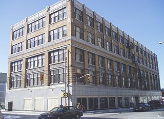
Charles Ogilvy Limited, or Ogilvy's, was a department store in Ottawa, Ontario, Canada, founded in 1887. For much of the 20th century, Ogilvy's was one of Ottawa's higher-end department stores.

The Archdiocese of Ottawa–Cornwall is a Catholic archdiocese that includes part of the Province of Ontario and includes the suffragan dioceses of Hearst, Pembroke, and Timmins. On 6 May 2020, Pope Francis amalgamated the Archdiocese of Ottawa and the Diocese of Alexandria-Cornwall to create the Archdiocese of Ottawa–Cornwall.
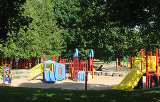
Brewer Park is a municipal park in Ottawa, Ontario, Canada. It is located on the north bank of the Rideau River at Bronson Avenue, across from Carleton University.
George Harrison Dunbar was an Ontario political figure. He represented Ottawa South in the Legislative Assembly of Ontario as a Conservative and then Progressive Conservative member from 1937 to 1959.
The Mackenzie King Bridge is a bridge over the Rideau Canal in Ottawa, Ontario, Canada. Just a few blocks away from Parliament Hill, south of the Plaza Bridge, it runs in a generally east–west direction, with the east end at the Rideau Centre and Department of National Defence Headquarters. The west end runs between the National Arts Centre and Confederation Park. It was named for William Lyon Mackenzie King (1874–1950), Canada's longest-serving prime minister and was opened to traffic in 1951. A major restoration effort was completed in 1996–1998.

Navan is a community in Orléans South-Navan Ward in Ottawa, Ontario, Canada. It is located about 20 km east of the city of Ottawa and the centre of the town is Colonial Road and Trim Road. It is located southeast of the suburban community of Orleans. About 1,864 people live in the vicinity of Navan as of 2021.
The Plaza Bridge in Ottawa, Ontario, Canada, is an automotive and pedestrian bridge that crosses the Rideau Canal just south of the Ottawa locks. It joins Wellington Street and Elgin Street in the Downtown core to the west with Rideau Street to the east. The Chateau Laurier abuts the bridge at the east end, while Parliament Hill is just beyond the west end. It is the northernmost bridge over the canal, just north of the Mackenzie King Bridge.
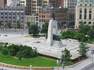
Confederation Square is an urban square in Ottawa, Ontario, Canada, and is considered the second most important ceremonial centre in Canada's capital city, after Parliament Hill. Roughly triangular in area, with Canada's National War Memorial at its centre and the Valiants Memorial at its periphery, the square is bounded by Wellington Street to the north and branches of Elgin Street to the east and west.

Trinity Anglican Church is an Anglican church in central Ottawa, Ontario, Canada.

The Adàwe Crossing is a pedestrian and cyclist bridge in Ottawa, Ontario, Canada, built across the Rideau River. It is located about 1,200 metres (1,300 yd) north (downstream) of the Highway 417 bridge and 800 metres (870 yd) south (upstream) from the Cummings Bridge. It was opened on December 4, 2015 and links the communities of Overbrook and Sandy Hill.
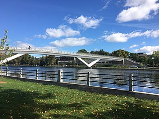
The Flora Footbridge, named after Flora MacDonald, is a pedestrian/cycling bridge in Ottawa, Ontario, Canada, that spans the Rideau Canal, connecting Clegg Street in Old Ottawa East to Fifth Avenue in the Glebe. It also crosses Colonel By Drive.
