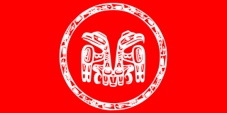
Haida are an indigenous group who have traditionally occupied Haida Gwaii, an archipelago just off the coast of British Columbia, Canada for at least 12,500 years.

Haida Gwaii is an archipelago located between 55–125 km (34–78 mi) off the northern Pacific coast of Canada. The islands are separated from the mainland to the east by the shallow Hecate Strait. Queen Charlotte Sound lies to the south, with Vancouver Island beyond. To the north, the disputed Dixon Entrance separates Haida Gwaii from the Alexander Archipelago in the U.S. state of Alaska.
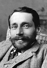
George Mercer Dawson was a Canadian geologist and surveyor. He was born in Pictou, Nova Scotia, the eldest son of Sir John William Dawson, Principal of McGill University and a noted geologist, and his wife, Lady Margaret Dawson. By age 11, he was afflicted with tuberculosis of the spine that resulted in a deformed back and stunted growth. Physical limitations, however, did not deter Dawson from becoming one of Canada's greatest scientists.
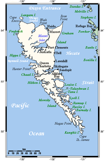
Graham Island is the largest island in the Haida Gwaii archipelago, lying off the coast of British Columbia, Canada. It is separated only by a narrow channel from the other principal island of the group, Moresby Island. It has a population of 3,858, an area of 6,361 km2 (2,456 sq mi), and is the 101st largest island in the world and Canada's 22nd largest island.

The Dixon Entrance is a strait about 80 kilometers (50 mi) long and wide in the Pacific Ocean at the Canada–United States border, between the U.S. state of Alaska and the province of British Columbia in Canada. The Dixon Entrance is part of the Inside Passage shipping route. It forms part of the maritime boundary between the U.S. and Canada, although the location of that boundary here is disputed.
The North Coast Regional District is a quasi-municipal administrative area in British Columbia. It is located on British Columbia's west coast and includes Haida Gwaii, the largest of which are Graham Island and Moresby Island. Its administrative offices are in the City of Prince Rupert.

Masset, formerly Massett, is a village in Haida Gwaii in British Columbia, Canada. It is located on Masset Sound on the northern coast of Graham Island, the largest island in the archipelago, and is approximately 50 km (31 mi) west of mainland British Columbia. It is the primary western terminus of Trans-Canada Highway 16 and is served by Masset Airport, with flights to Vancouver and Prince Rupert. During the maritime fur trade of the early 19th century, Masset was a key trading site. It was incorporated as a village municipality on May 11, 1961.

Port Clements is an incorporated village situated at the east end of Masset Inlet in Haida Gwaii off the coast of the Province of British Columbia in Canada. Known as Gamadiis in HlG̱aagilda X̱aayda kil, it is one of seven village sites that flourished in the rich waters at the mouth of Yakoun River, where an estuary shelters nine Pacific salmonid species and many kinds of birds. Founded by Eli Tingley in 1907, it was once known under the name Queenstown, but renamed to Port Clements in 1914 after Herb S. Clements, the local MP at the time, when the name "Queenstown" duplicated and therefore became unusable for the post office.
Robert Charles Davidson, CM, OBC, is a Canadian artist of Haida heritage. Davidson's Haida name is G̲uud San Glans, which means "Eagle of the Dawn". He is a leading figure in the renaissance of Haida art and culture.
School District 50 Haida Gwaii is a school district in British Columbia, Canada. It covers Haida Gwaii off the north coast of British Columbia immediately west of Prince Rupert. Centered in Queen Charlotte City, it includes the communities of Sandspit, Masset, Skidegate, and Port Clements.

Northern Health is the publicly funded healthcare provider for the northern half of the Canadian province of British Columbia. Northern Health serves over 300,000 people in an area of 600,000 square kilometres. It was established as one of five geographically based health authorities in 2001 by the Government of British Columbia.
The Queen Charlottes Gold Rush was a gold rush in southern Haida Gwaii of what is now the North Coast of British Columbia, Canada, in 1851.

Tow Hill is a large isolated volcanic plug located 21 km (13 mi) east of Masset on the north end of the Naikoon Peninsula of northeast Graham Island in Haida Gwaii, British Columbia, Canada, east of McIntyre Bay and near the mouth of the Hiellen River, which is the site of Hiellen, a now-abandoned Haida village and of the Hiellen Indian Reserve No. 2, on the site of that village. Formerly Tow Hill Provincial Park, it is now part of Naikoon Provincial Park, which covers most of the northeastern flatland of Graham Island.

Naikoon Provincial Park is a provincial park on northeastern Graham Island in the Haida Gwaii archipelago, British Columbia, Canada. It is the ancestral home of the Gwak'rala'chala people, one of the many tribes that form the native group Haida. While it is a popular destination for adventurous campers, it is also very secluded, being over 16 km (9.9 mi) away from Masset.
Ḵung is a Haida village, located on the west side of Alexandra Narrows on Graham Island, the largest and northernmost island of Haida Gwaii alongside British Columbia, Canada. Alexandra Narrows, known on some old maps as Mazzaredo Sound, connects Naden Harbour and Virago Sound. An earlier village located at the current village site was named ‘Nightasis’ by the fur trader John Work, and records that in 1840 there were 15 houses with 280 residents.

The 2012 Haida Gwaii earthquake occurred just after . The shock had a moment magnitude of 7.8 and a maximum Mercalli Intensity of VIII (Severe). The earthquake's epicentre was on Moresby Island of the Haida Gwaii archipelago. This was the second largest Canadian earthquake ever recorded by a seismometer, after the 1949 Queen Charlotte Islands earthquake, about 135 kilometres (84 mi) away.

Old Massett, named G̱aw in X̱aad kíl, is an Aboriginal Canadian village on Graham Island in Haida Gwaii, British Columbia. It lies on the east side of Masset Sound close to the town of Masset; the area of land it is on is legally designated Masset Indian Reserve No. 1, or Masset 1. The original name of the settlement was Uttewas, meaning "white-slope village" in the Haida language. It is populated by Haida people of both Ḵuustak, the Eagle matrilineage, and Ḵayx̱al, the Raven matrilineage. The town is administered by the Old Massett Village Council. Its population has fluctuated over the last one hundred and fifty years; smallpox, especially the 1862 Pacific Northwest smallpox epidemic, drastically reduced its numbers in the late 1800s, but in 1968, it had over 1,000 people and was the largest village in Haida Gwaii. In 2009, the Village Council counted 2,698 band members in the area; the 2016 census counted 555 living at the Old Massett townsite.
Gudangaay Tlaats'gaa Naay Secondary, formerly George M Dawson Secondary School, is a public high school in Masset, British Columbia. It is one of two secondary schools and one of six schools in School District 50 Haida Gwaii. George Mercer Dawson Secondary officially opened on October 19, 1970, and was named after George Mercer Dawson, a Canadian scientist, surveyor and eminent authority on ethnology and archeology who undertook the Canadian Governments Geological Survey of Haida Gwaii, formerly named Queen Charlotte Islands. In September, 2016 the school was renamed to Gudangaay Tlaats'gaa Naay Secondary by unanimous decision of the SD50 School Board.
Dadens (daa.adans), also referred to as Tartenee and Tatense by some early European settlers and Tatense Reserve 16 under the Indian Act is village on the southern coast of Langara Island belonging to the Haida Nation on the archipelago Haida Gwaii, British Columbia, Canada. Dadens was once a popular trading post for the North Pacific fur trade among European traders in the late 18th century, due to its size and accessibility. Dadens no longer continues to be used by families year round, but it was used as a fishing village during the summer months by many Haida up until the 1950s and 1960s, and is still used to a limited extent today. There have been multiple migrations of families from Dadens to South East Alaska and these people are now known as the Kiagani Haida.
Kiusta located on Haida Gwaii is the oldest Northern Haida village: and the site of first recorded contact between the Haida and Europeans in 1774. Haida lived in this village for thousands of years, due to the sheltered nature of its location it was used for boats offloading, especially in rough waters. Kiusta is one of the oldest archeological sites of human use in British Columbia, and continues to be a site for cultural revitalisation.
