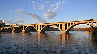
The Francis Scott Key Bridge, more commonly known as the Key Bridge, is a six-lane reinforced concrete arch bridge carrying U.S. Route 29 (US 29) across the Potomac River between the Rosslyn neighborhood of Arlington County, Virginia, and the Georgetown neighborhood of Washington, D.C. Completed in 1923, it is Washington's oldest surviving road bridge across the Potomac River.

Interstate 235 (I-235) in Iowa is an auxiliary Interstate Highway that runs just north of downtown Des Moines through the heart of the Des Moines metropolitan area. I-235 runs from the junction of I-35 and I-80 in West Des Moines to the separation of the same two Interstates in Ankeny. The highway is approximately 14 miles (23 km) long.

The Washington Bridge is a 2,375-foot (724 m)-long arch bridge over the Harlem River in New York City between the boroughs of Manhattan and the Bronx. The crossing, opened in 1888, connects 181st Street and Amsterdam Avenue in Washington Heights, Manhattan, with University Avenue in Morris Heights, Bronx. It carries six lanes of traffic, as well as sidewalks on both sides. Ramps at either end of the bridge connect to the Trans-Manhattan Expressway and the Cross Bronx Expressway, and serves as a connector/highway to the highway itself.

James Barney Marsh was an American engineer and bridge designer. He patented a new design for arch bridges. Marsh gave Archie Alexander, the first African-American to graduate as an engineer from Iowa State University, his first job. Marsh worked in the bridge building business for over 50 years, and several of his bridges are listed in the National Register of Historic Places.

U.S. Highway 6 (US 6) is an east–west United States Numbered Highway which runs 322 miles (518 km) across the U.S. state of Iowa. The route is signed in places as the Grand Army of the Republic Highway. Like all state highways in Iowa, it is maintained by the Iowa Department of Transportation. The route begins at the Missouri River crossing at Council Bluffs. From there, it travels east through Oakland and Atlantic. North of Atlantic, the highway overlaps Interstate 80 (I-80) until De Soto. Between De Soto and Adel, the highway overlaps US 169 before splitting off to the east toward Des Moines. Through the Des Moines area, the highway runs about one mile (1.6 km) north or south of the I-35/I-80 corridor.

Miguel Rosales is president and principal designer of Rosales + Partners, an architecture firm based in Boston, Massachusetts. He specializes in bridge aesthetics and design. Some examples of these bridges include; Phyllis J. Tilley Memorial Bridge, Christina and John Markey Memorial Pedestrian Bridge, and Liberty Bridge at Falls Park on the Reedy River.
Interstate 80 (I-80) is a transcontinental Interstate Highway in the United States, stretching from San Francisco, California, to Teaneck, New Jersey. In Iowa, the highway travels west to east through the center of the state. It enters the state at the Missouri River in Council Bluffs and heads east through the southern Iowa drift plain. In the Des Moines metropolitan area, I-80 meets up with I-35 and the two routes bypass Des Moines together. On the northern side of Des Moines, the Interstates split and I-80 continues east. In eastern Iowa, it provides access to the University of Iowa in Iowa City. Northwest of the Quad Cities in Walcott is Iowa 80, the world's largest truck stop. I-80 passes along the northern edge of Davenport and Bettendorf and leaves Iowa via the Fred Schwengel Memorial Bridge over the Mississippi River into Illinois.

The Frederick Douglass–Susan B. Anthony Memorial Bridge is a triple steel arch bridge carrying Interstate 490 (I-490) over the Genesee River and New York State Route 383 in downtown Rochester, New York. The bridge, officially completed on June 18, 2007, replaced a 50-year-old multi-girder bridge situated in the same location.

The Union Arch Bridge, also called the Cabin John Bridge, is a historic masonry structure in Cabin John, Maryland. It was designed as part of the Washington Aqueduct. The bridge construction began in 1857 and was completed in 1864. The roadway surface was added later. The bridge was designed by Alfred Landon Rives and built by the United States Army Corps of Engineers under the direction of Lieutenant Montgomery C. Meigs.

Wilson River Bridge, also known as Wilson River Bridge at Tillamook or Wilson River Bridge No. 01499, is a bridge near Tillamook, Oregon, United States. The 1931 bridge was designed by Conde McCullough in the Classical Revival and Art Deco styles. It covers a span of 180 feet (55 m) and brings coastal U.S. Route 101 (US 101) over the Wilson River.
The Henley Bridge, sometimes referred to as Henley Street Bridge, is a vehicle bridge that crosses the Tennessee River in Knoxville, Tennessee, United States. Completed in 1931, the 1,793-foot (547 m) bridge is one of four vehicle bridges connecting Downtown Knoxville with South Knoxville, the other three being the Gay Street Bridge, the Buck Karnes Bridge, named for James Ernest Karnes,, and the James C. Ford Memorial Bridge. The bridge carries U.S. Route 441, which is known as "Henley Street" in downtown Knoxville and "Chapman Highway" in South Knoxville.

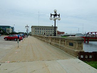
The Court Avenue Bridge is a historic structure located in downtown Des Moines, Iowa, United States. It became a contributing property in the Civic Center Historic District in 1988, and was individually listed on the National Register of Historic Places on May 15, 1998 as a part of the Highway Bridges of Iowa MPS.
The Civic Center Historic District is located in downtown Des Moines, Iowa, United States. It flanks both the Des Moines and Raccoon Rivers and their confluence. The district has been listed on the National Register of Historic Places since 1988. It is part of The City Beautiful Movement and City Planning in Des Moines, Iowa 1892—1938 MPS.
The Southwest Fifth St. Bridge is a historic structure located in downtown Des Moines, Iowa, United States. Built in 1898 after a controversy surrounding the bidding process, it is one of the last Pratt through truss bridges left in an urban setting in Iowa. The bridge was listed on the National Register of Historic Places in 1998 as a part of the Highway Bridges of Iowa MPS.

The Highland Park Historic Business District at Euclid and Sixth Avenues is located in the north-central section of Des Moines, Iowa, United States. It is located on the border of the Oak Park and Highland Park neighborhoods. The commercial historic district has been listed on the National Register of Historic Places since 1998. The Highland Park neighborhood also includes the College Corner Commercial Historic Business District.
The Jefferson Street Viaduct is a historic structure located in Ottumwa, Iowa, United States. The riveted Warren deck truss bridge was completed in 1936. It was listed on the National Register of Historic Places in 1998 as a part of the Highway Bridges of Iowa MPS.

Iowa Highway 46 (Iowa 46) was a state highway in Polk County, Iowa. It began at an intersection with Iowa 5 near Avon. It traveled north and west through the industrial section of southeastern Des Moines. It ended at Iowa 163, also known as E. University Avenue, in Des Moines next to the Iowa State Fairgrounds.
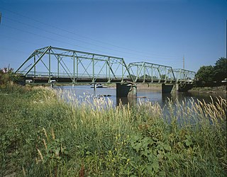
The Des Moines River Bridge is a historic bridge located southwest of Swea City, Iowa, United States. It spans the Des Moines River for 102 feet (31 m). In February 1916, the Kossuth County Board of Supervisors approved the contract for the Des Moines Marsh Engineering Company to build the bridges. It was designed by the company's engineer James B. Marsh. The 9-panel Marsh fixed arch bridge, also known as a "rainbow arch", was completed in 1916 for $7,150. It features two tapered concrete arches that carry the roadway in between them from hangers. It was listed on the National Register of Historic Places in 1998.

The Lincoln Highway in Greene County, Iowa is a multiple property submission to the National Register of Historic Places, which was approved on March 29, 1993. It includes five individual listings and five historic districts located in Greene County, Iowa, United States. They encompass abandoned sections of dirt roads, paved sections that are now part of other highways, and various sites, objects, structures and pieces of infrastructure that were a part of the Lincoln Highway. The years of historical significance are 1912 to 1928.

U.S. Highway 63 (US 63) is a United States Highway that runs through the eastern third of Iowa. It begins at the Missouri state line southwest of Bloomfield and travels north through Ottumwa, Oskaloosa, Tama, Waterloo, and New Hampton. It ends at the Minnesota state line at Chester. Between Ottumwa and Oskaloosa, the highway is a four-lane controlled-access highway. Through Waterloo and New Hampton, it is partially controlled; that is, the road as both grade-separated interchanges and at-grade intersections. The rest of the highway is largely a two-lane rural highway.

