State Route 14 (SR 14) is a 87.4-mile-long (140.7 km) state highway that travels southwest-to-northeast through portions of Troup, Coweta, and Fulton counties in the west-central and north-central parts of the U.S. state of Georgia. The highway connects the Alabama state line in West Point to Downtown Atlanta, via LaGrange, Fairburn, College Park, and East Point. Except for the northernmost segment, it is entirely concurrent with U.S. Route 29 (US 29).

State Route 376 (SR 376) is a 16.0-mile-long (25.7 km) east–west state highway that travels within portions of Lowndes and Echols counties in the southern part of the U.S. state of Georgia. It connects Clyattville with the Statenville area, via Lake Park. The roadway was built in the late 1950s and designated as SR 376 in 1972.

State Route 378 (SR 378) is a 6.4-mile-long (10.3 km), four-lane state highway that travels west-to-east entirely within Gwinnett County in the north-central part of the U.S. state of Georgia. The route is heavily commercialized with numerous office and industrial parks. It is known along its entire length as Beaver Ruin Road. The roadway was built in the mid-1960s and designated a decade later.

State Route 382 (SR 382) is a 11.6-mile-long (18.7 km) state highway that travels west-to-east in a squiggly-curved C-shape entirely within Gilmer County in the north-central part of the U.S. state of Georgia. It serves as a connecting route from SR 136 south of Carters Lake to Georgia State Route 5/SR 515 south-southwest of Ellijay. The route can be used to access the southern shores of Carters Lake.
State Route 360 (SR 360) is a 15.5-mile-long (24.9 km) state highway located in the northwestern part of the U.S. state of Georgia. The highway connects Hiram with Marietta, and travels within portions of Paulding and Cobb counties.

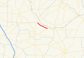
State Route 358 (SR 358) is a 6.4-mile-long (10.3 km) west–east state highway located entirely in the southeastern part of Twiggs County in the central part of the U.S. state of Georgia. It is mainly a rural route. The highway was built along its current alignment between 1963 and 1966.
State Route 341 (SR 341) is a 15.5-mile-long (24.9 km) north–south state highway located entirely within Walker County in the northwestern part of the U.S. state of Georgia. It connects the unincorporated community of Davis Crossroads with Chattanooga Valley, via Chickamauga.
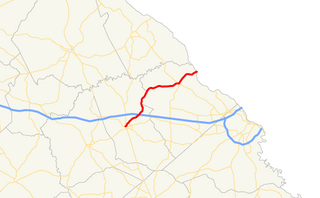
State Route 338 (SR 338) is a 22.3-mile-long (35.9 km) state highway that travels south-to-north in a sideways V-shape completely within Laurens County in the central part of the U.S. state of Georgia. It connects Cadwell with the Dublin area, via Dudley.

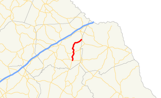
State Route 334 (SR 334) is a 12.4-mile-long (20.0 km) south-to-north state highway located entirely within Jackson County in the northeastern part of the U.S. state of Georgia. It travels from north of Athens to Commerce. It is effectively an alternate route of U.S. Route 441 (US 441).
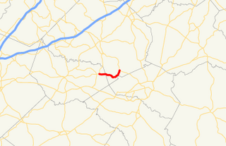
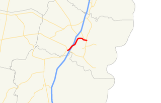
State Route 330 (SR 330) is a 6.1-mile-long (9.8 km) state highway in the northeastern part of the U.S. state of Georgia. It travels through rural areas of Barrow and Jackson counties.
State Route 327 (SR 327) is a 9.8-mile-long (15.8 km) north-south state highway that is located entirely in Franklin County in the northeast part of the U.S. state of Georgia.

State Route 323 (SR 323) is a 14.1-mile-long (22.7 km) southwest-to-northeast state highway in the northeastern part of the U.S. state of Georgia. Except for the portion in Gillsville, the entire highway travels through rural areas of Hall and Banks counties.
State Route 303 (SR 303) is a 9.1-mile-long (14.6 km) south–north state highway in the southeast part of the U.S. state of Georgia. It travels completely within Glynn County, and is in the Brunswick metropolitan area.

State Route 101 (SR 101) is a 43.5-mile-long (70.0 km) state highway in the northwestern part of the U.S. state of Georgia. It travels in a south-north orientation between the Atlanta metropolitan area and the Alabama state line. Its routing passes through portions of Carroll, Paulding, Polk, and Floyd counties. It connects the Villa Rica and Rome areas of the state.

State Route 119 (SR 119) is an 81.2-mile-long (130.7 km) state highway that runs south-to-north in the east-central part of the U.S. state of Georgia. It runs from Riceboro to the Hinesville – Fort Stewart metropolitan area and curves to the northeast, through Pembroke and Springfield, and enters South Carolina north of Clyo, where the roadway continues as South Carolina Highway 119.

State Route 83 (SR 83) is an 86.5-mile-long (139.2 km) state highway that runs southwest to northeast, with a southeast–to–northwest section, within portions of Monroe, Jasper, Morgan, and Walton counties in the central part of the U.S. state of Georgia. It connects Forsyth, Monticello, and Madison. The portion from the southwestern city limits of Monticello to the Jasper–Morgan county line is included in the Monticello Crossroads Scenic Byway.

State Route 184 (SR 184) is a 19.4-mile (31.2 km) state highway that runs south-to-north through portions of Banks and Stephens counties in the northeastern part of the U.S. state of Georgia. The route's southern terminus is at SR 63 in northeastern Banks County. The northern terminus at the Tugaloo River and the South Carolina state line where the road continues as Cleveland Pike Road.
State Route 182 is a 8.7-mile (14.0 km) state highway that runs west–east through northern Ben Hill County in the south-central part of the U.S. state of Georgia.
State Route 150 (SR 150) is a 25.3-mile-long (40.7 km) state highway that travels southwest–to–northeast through portions of McDuffie and Columbia counties in the east-central part of the U.S. state of Georgia. It travels from Thomson northeast to the South Carolina state line, southwest of Clarks Hill, South Carolina.