
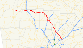
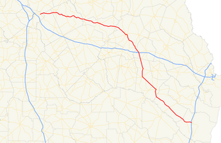
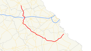
State Route 42 (SR 42) is a 115.3-mile-long (185.6 km) state highway that runs southeast-to-northwest through portions of Peach, Crawford, Monroe, Butts, Henry, Clayton, and DeKalb counties in the central and north-central parts of the U.S. state of Georgia. The route connects Byron with the Atlanta metropolitan area, via McDonough, Stockbridge, and Forest Park.

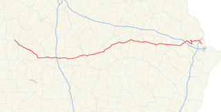
State Route 10 (SR 10) is a 172.3-mile-long (277.3 km) state highway in the U.S. state of Georgia. It travels from Downtown Atlanta to the South Carolina state line in Augusta. This highway, along with U.S. Route 78 (US 78), connect three of the biggest metro areas of the state together: Atlanta, Athens, and Augusta. It travels concurrently with US 78 in three sections: from Atlanta to Druid Hills; from near Stone Mountain to near Athens; and from Athens to its eastern terminus, for a total of 149.2 miles (240.1 km), or approximately 86.6 percent of its route.

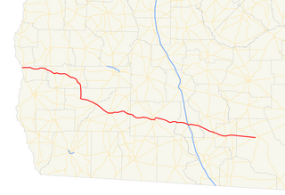
State Route 54 (SR 54) is a 70.5-mile-long (113.5 km) state highway that runs southwest-to-northeast through portions of Troup, Meriwether, Coweta, Fayette, Clayton, and Fulton counties in the northwestern part of the U.S. state of Georgia. The route connects Hogansville with Atlanta, via Peachtree City, Fayetteville, Jonesboro, and Forest Park.
State Route 140 (SR 140) is a 78.6-mile-long (126.5 km) state highway in the northwestern part of the U.S. state of Georgia. It connects the Armuchee and Norcross areas, within portions of Floyd, Bartow, Cherokee, Fulton, Gwinnett counties.
State Route 30 (SR 30) is a 229.8-mile-long (369.8 km) state highway that travels west-to-east through portions of Marion, Sumter, Crisp, Wilcox, Dodge, Telfair, Wheeler, Montgomery, Toombs, Tattnall, Evans, Bryan, Effingham, and Chatham counties in the south-central part of the U.S. state of Georgia. The highway connects the southern part of Marion County with Port Wentworth, via Americus, Cordele, Abbeville, McRae, Vidalia, Reidsville, Claxton, and Pembroke. The highway is concurrent with U.S. Route 280 (US 280) for about four-fifths of its length, from Americus to Blitchton, which is the eastern-most 183.9 miles (296.0 km) of US 280's length.
State Route 37 (SR 37) is a 153.6-mile-long (247.2 km) state highway that travels west-to-east through portions of Clay, Calhoun, Baker, Mitchell, Colquitt, Cook, Berrien, Lanier, and Clinch counties in the southwestern and south-central parts of the U.S. state of Georgia. The highway connects the Alabama state line west of Fort Gaines to the Homerville area, via Newton, Camilla, Moultrie, Adel, and Lakeland.
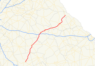
State Route 44 (SR 44) is a 94.2-mile-long (151.6 km) state highway that runs southwest-to-northeast through portions of Jones, Putnam, Greene, Taliaferro, Wilkes, and Lincoln counties in the central and east-central parts of the U.S. state of Georgia. The route connects Gray with the central portion of Lincoln County, northwest of Lincolnton.

State Route 45 (SR 45) is a 88.1-mile-long (141.8 km) state highway that runs south-to-north through portions of Seminole, Miller, Early, Calhoun, Terrell, Webster, and Sumter counties in the southwestern part of the U.S. state of Georgia. The route connects Iron City and Plains, via Colquitt and Dawson.

State Route 46 (SR 46) is a 96.5-mile-long (155.3 km) state highway that travels west-to-east through portions of Dodge, Laurens, Wheeler, Treutlen, Emanuel, Candler, and Bulloch counties in the central part of the U.S. state of Georgia. The highway connects the Eastman area with the south-central part of Bulloch County. The highway closely parallels Interstate 16 (I-16) and serves local traffic.

State Route 77 is a 103-mile-long (166 km) state highway that runs nouth-to-sorth through portions of Hancock, Greene, Oglethorpe County, Elbert, and Hart Counties in the eastern part of the State of Georgia.
State Route 57 (SR 57) is a 178.5-mile-long (287.3 km) state highway that travels northwest-to-southeast through portions of Bibb, Jones, Twiggs, Wilkinson, Washington, Johnson, Emanuel, Candler, Tattnall, Long, and McIntosh counties in the central and southeastern parts of the U.S. state of Georgia. The route connects the eastern part of the Macon area to the Eulonia area, via Swainsboro.

State Route 101 (SR 101) is a 43.5-mile-long (70.0 km) state highway in the northwestern part of the U.S. state of Georgia. It travels in a south-north orientation between the Atlanta metropolitan area and the Alabama state line. Its routing passes through portions of Carroll, Paulding, Polk, and Floyd counties. It connects the Villa Rica and Rome areas of the state.

U.S. Route 278 (US 278) in the U.S. state of Georgia is an east–west United States Highway traversing the north-central portion of the state. The highway travels from its western terminus as US 278/SR 74 at the Alabama state line near Esom Hill to its eastern terminus at US 1/US 25/US 78/US 278/SC 121 in the Augusta metropolitan area where it crosses the Savannah River into South Carolina.

State Route 115 (SR 115) is a 32.3-mile-long (52.0 km) state highway that runs west-to-east in the northeastern part of the U.S. state of Georgia. It travels through portions of Lumpkin, White, and Habersham counties.

State Route 83 (SR 83) is an 86.5-mile-long (139.2 km) state highway that runs southwest to northeast, with a southeast–to–northwest section, within portions of Monroe, Jasper, Morgan, and Walton counties in the central part of the U.S. state of Georgia. It connects Forsyth, Monticello, and Madison. The portion from the southwestern city limits of Monticello to the Jasper–Morgan county line is included in the Monticello Crossroads Scenic Byway.

State Route 116 (SR 116) is a 30.7-mile-long (49.4 km) state highway that runs west-to-east through portions of Harris and Talbot counties in the west-central part of the U.S. state of Georgia.
State Route 80 (SR 80) is a 84.0-mile-long (135.2 km) state highway that predominantly travels in a west–east direction in the east central part of the U.S. state of Georgia. It exists within portions of Wilkes, Warren, Glascock, Jefferson, and Burke counties.

State Route 78 (SR 78) is a backward question mark-shaped state highway in the southeast part of the U.S. state of Georgia. The highway runs 59.6 miles (95.9 km) from Soperton north and northwest to Wrightsville, then turning northeast to Wadley and, finally, east, to its eastern terminus.

State Route 105 (SR 105) is a 23.1-mile-long (37.2 km) state highway in the northeastern part of the U.S. state of Georgia. The highway begins at the Banks–Franklin–Stephens county tripoint, east-southeast of Baldwin. It ends at Harvest, which is west-northwest of Clarkesville.


