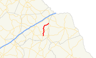
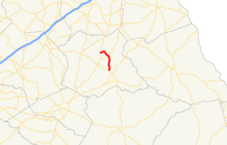
State Route 327 (SR 327) is a 9.8-mile-long (15.8 km) north-south state highway that is located entirely in Franklin County in the northeast part of the U.S. state of Georgia.
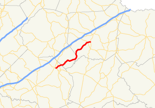
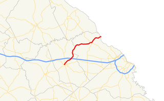
State Route 326 (SR 326) is a 16.4-mile-long (26.4 km) southwest-to-northeast state highway located mostly in rural areas of the northeastern part of the U.S. state of Georgia. Its route travels within portions of Jackson, Banks, and Franklin counties.

State Route 77 is a 103-mile-long (166 km) state highway that runs nouth-to-sorth through portions of Hancock, Greene, Oglethorpe County, Elbert, and Hart Counties in the eastern part of the State of Georgia.
State Route 284 (SR 284) is a south-north state highway located in the northeastern part of the U.S. state of Georgia. The route's routing is in Hall and White counties.

State Route 270 (SR 270) is a 12.7-mile-long (20.4 km) east–west state highway located in the southern part of the U.S. state of Georgia. Its route is within Mitchell and Colquitt counties.

State Route 262 (SR 262) is a 44.4-mile-long (71.5 km) L-shaped state highway located in the southwestern part of the U.S. state of Georgia. It travels within portions of within Decatur and Mitchell counties, and skims the border of Grady County.

State Route 243 (SR 243) was a 21.2-mile-long (34.1 km) north–south state highway located in the central part of the U.S. state of Georgia. It existed in portions of Wilkinson and Baldwin counties.

State Route 59 (SR 59) is a 32.3-mile-long (52.0 km) state highway that runs southwest-to-northeast through portions of Jackson, Banks, Franklin, and Hart counties in the northeastern part of the U.S. state of Georgia. The route connects Commerce with SR 77 near the shore of Lake Hartwell. The highway passes through Carnesville and Lavonia. It closely parallels Interstate 85 (I-85).
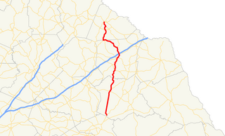
State Route 106 (SR 106) is a 45.2-mile-long (72.7 km) state highway that runs south-to-north through portions of Madison, Franklin, and Stephens counties in the northeastern part of the U.S. state of Georgia.

State Route 83 (SR 83) is an 86.5-mile-long (139.2 km) state highway that runs southwest to northeast, with a southeast–to–northwest section, within portions of Monroe, Jasper, Morgan, and Walton counties in the central part of the U.S. state of Georgia. It connects Forsyth, Monticello, and Madison. The portion from the southwestern city limits of Monticello to the Jasper–Morgan county line is included in the Monticello Crossroads Scenic Byway.

State Route 63 (SR 63) is a 23.1-mile-long (37.2 km) state highway in the northeastern part of the U.S. state of Georgia. It and SR 59 serve to connect Commerce and Toccoa.

State Route 71 (SR 71) is a state highway in the northwest part of the U.S. state of Georgia. The highway runs 13.6 miles (21.9 km) from Dalton northeast and, then, north, to the Tennessee state line, northeast of Cohutta, where the roadway continues as Tennessee State Route 60.

State Route 105 (SR 105) is a 23.1-mile-long (37.2 km) state highway in the northeastern part of the U.S. state of Georgia. The highway begins at the Banks–Franklin–Stephens county tripoint, east-southeast of Baldwin. It ends at Harvest, which is west-northwest of Clarkesville.

State Route 227 (SR 227) is a 2.2-mile-long (3.5 km) connecting state highway that travels south-to-north through portions of Treutlen County in the east-central part of the U.S. state of Georgia.
State Route 191 (SR 191) is a state highway that runs south-to-north in an arc east and north around the Danielsville area, which is northeast of Athens. Its route is located entirely within Madison county in the northeastern part of the U.S. state of Georgia.

State Route 184 (SR 184) is a 19.4-mile (31.2 km) state highway that runs south-to-north through portions of Banks and Stephens counties in the northeastern part of the U.S. state of Georgia. The route's southern terminus is at SR 63 in northeastern Banks County. The northern terminus at the Tugaloo River and the South Carolina state line where the road continues as Cleveland Pike Road.

State Route 181 is a state highway in the northeastern part of the U.S. state of Georgia. It runs west–east through portions of Hart county.

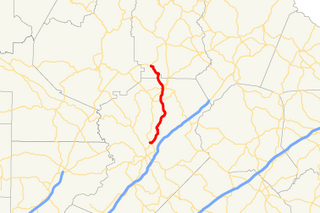
State Route 174 (SR 174) is a 12.6-mile-long (20.3 km) L-shaped state highway in the northeastern part of the U.S. state of Georgia. Its routing exists within portions of Madison and Franklin counties.
State Route 150 (SR 150) is a 25.3-mile-long (40.7 km) state highway that travels southwest–to–northeast through portions of McDuffie and Columbia counties in the east-central part of the U.S. state of Georgia. It travels from Thomson northeast to the South Carolina state line, southwest of Clarks Hill, South Carolina.
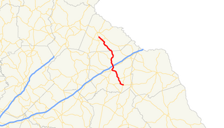
State Route 145 (SR 145) is a 24.3-mile-long (39.1 km) state highway that runs southeast-to-northwest through portions of Franklin and Stephens counties in the northeastern part of the U.S. state of Georgia. The route connects Franklin Springs with Toccoa.


