Georgia State Route 352

Last updated

Georgia 352.svg

State Route 352
Georgia state route 352 map.png
Route information
Maintained by GDOT
Length 9.8 mi [1] (15.8 km)
Existed 1963 (1963) [2] [3] – present
Major junctions
South endGeorgia 41.svg SR 41 north-northwest of Buena Vista
North endGeorgia 355.svg SR 355 south-southwest of Juniper
Location
Counties Marion
Highway system
  • Georgia State Routes
Georgia 348.svg SR 348 SR 354 Georgia 354.svg

State Route 352 (SR 352) is a 9.8-mile-long (15.8 km) southeast-to-northwest state highway in northwestern Marion County in the west-central part of the U.S. state of Georgia. Its entire length is located just to the east of Fort Benning.

Marion County, Georgia County in the United States

Marion County is a county located in the U.S. state of Georgia. As of the 2010 Census reflected a population of 8,742. The county seat is Buena Vista. The county was created on December 14, 1827. The county was named for General Francis Marion of South Carolina.

U.S. state constituent political entity of the United States

In the United States, a state is a constituent political entity, of which there are currently 50. Bound together in a political union, each state holds governmental jurisdiction over a separate and defined geographic territory and shares its sovereignty with the federal government. Due to this shared sovereignty, Americans are citizens both of the federal republic and of the state in which they reside. State citizenship and residency are flexible, and no government approval is required to move between states, except for persons restricted by certain types of court orders. Four states use the term commonwealth rather than state in their full official names.

Georgia (U.S. state) State of the United States of America

Georgia is a state in the Southeastern United States. It began as a British colony in 1733, the last and southernmost of the original Thirteen Colonies to be established. Named after King George II of Great Britain, the Province of Georgia covered the area from South Carolina south to Spanish Florida and west to French Louisiana at the Mississippi River. Georgia was the fourth state to ratify the United States Constitution, on January 2, 1788. In 1802–1804, western Georgia was split to the Mississippi Territory, which later split to form Alabama with part of former West Florida in 1819. Georgia declared its secession from the Union on January 19, 1861, and was one of the original seven Confederate states. It was the last state to be restored to the Union, on July 15, 1870. Georgia is the 24th largest and the 8th most populous of the 50 United States. From 2007 to 2008, 14 of Georgia's counties ranked among the nation's 100 fastest-growing, second only to Texas. Georgia is known as the Peach State and the Empire State of the South. Atlanta, the state's capital and most populous city, has been named a global city. Atlanta's metropolitan area contains about 55% of the population of the entire state.

Contents

Route description

SR 352 begins at an intersection with SR 41 north-northwest of Buena Vista, just to the east of Brantley. The highway travels to the northwest through generally rural parts of the county, until it meets its northern terminus, an intersection with SR 355 south-southwest of the community of Juniper. [1]

Intersection (road) A road junction where two or more roads either meet or cross at grade

An intersection is an at-grade junction where two or more roads meet or cross. Intersections may be classified by number of road segments, traffic controls, and/or lane design.

Georgia State Route 41 highway in Georgia

State Route 41 (SR 41) is a 134.5-mile-long (216.5 km) state highway that runs south-to-north through portions of Calhoun, Randolph, Terrell, Webster, Marion, Talbot, Meriwether, and Coweta counties in the southwestern and west-central parts of the U.S. state of Georgia. The route connects the Morgan area to Moreland, via Buena Vista, Manchester, Warm Springs, and Greenville.

Buena Vista, Georgia City in Georgia, United States

Buena Vista is a city in Marion County, Georgia, United States. It is part of the Columbus, Georgia-Alabama Metropolitan Statistical Area. The population was 1,664 at the 2000 census. Formerly known as Pea Ridge, the city changed its name to Buena Vista in honor of Zachary Taylor's victory in the Mexican–American War. The city is the county seat of Marion County. It is the birthplace of baseball legend, Josh Gibson and Medal of Honor recipient Luther H. Story. The visionary art site Pasaquan is located four miles (6 km) from Buena Vista, in rural Marion County.

History

SR 352 was built along its current alignment between 1960 and 1963. [2] [3] By 1966, the entire length of road was paved. [3] [4]

Major intersections

The entire route is in Marion County.

Locationmi [1] kmDestinationsNotes
0.00.0Georgia 41.svg SR 41  Buena Vista Southern terminus
9.815.8Georgia 355.svg SR 355  Juniper Northern terminus
1.000 mi = 1.609 km; 1.000 km = 0.621 mi

See also

Related Research Articles

Georgia State Route 331 highway in Georgia

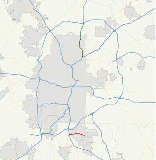
State Route 331 (SR 331) is a 3.3-mile-long (5.3 km) state highway located entirely within the northern part of Clayton County in the U.S. state of Georgia. It is the numbered highway portion of Forest Parkway, which continues both west and east of this highway. It connects areas south of Atlanta's Hartsfield–Jackson Atlanta International Airport with Forest Park and Lake City.

Russell–Brasstown Scenic Byway highway in Georgia

The Russell–Brasstown Scenic Byway is a National Scenic Byway in the U.S. state of Georgia that includes parts of Georgia State Route 17 (SR 17), SR 75, SR 180, and SR 75 Alternate, as well as the entire length of SR 348.

Georgia State Route 339 highway in Georgia

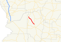
State Route 339 (SR 339) is a 3.5-mile-long (5.6 km) state highway completely within Towns County near Young Harris, Georgia, in the North Georgia mountains, just south of the North Carolina state line. It is locally known as Crooked Creek Road.

Georgia State Route 377 highway in Georgia

State Route 377 (SR 377) is a 20.0-mile-long (32.2 km) state highway that travels south-to-north through portions of Lee and Sumter counties in the southwestern part of the U.S. state of Georgia. The roadway was built in the late 1950s and was designated as SR 377 in the mid-1970s.

Georgia State Route 378 highway in Georgia

State Route 378 (SR 378) is a 6.4-mile-long (10.3 km), four-lane state highway that travels west-to-east entirely within Gwinnett County in the north-central part of the U.S. state of Georgia. The route is heavily commercialized with numerous office and industrial parks. It is known along its entire length as Beaver Ruin Road. The roadway was built in the mid-1960s and designated a decade later.

Georgia State Route 384 highway in Georgia

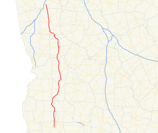
State Route 384 (SR 384) is a 15.6-mile-long (25.1 km) state highway in the northeast part of the U.S. state of Georgia. It travels southeast-to-northwest along Duncan Bridge Road from US 23/SR 365 in the western part of Baldwin to SR 75 southeast of Helen. The route serves as a gateway to Helen and the North Georgia mountains.

Georgia State Route 358 highway in Georgia

State Route 358 (SR 358) is a 6.4-mile-long (10.3 km) west–east state highway located entirely in the southeastern part of Twiggs County in the central part of the U.S. state of Georgia. It is mainly a rural route. The highway was built along its current alignment between 1963 and 1966.

Georgia State Route 356 highway in Georgia

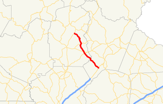
State Route 356 (SR 356) is a 10.8-mile-long (17.4 km) east–west state highway located in the northeast part of the U.S. state of Georgia. Its routing is located within portions of White and Habersham counties. Virtually the entire route is contained within the Chattahoochee-Oconee National Forest.

Georgia State Route 355 highway in Georgia

State Route 355 (SR 355) is a 19.9-mile-long (32.0 km) south–north state highway in the west-central part of the U.S. state of Georgia. Its route is contained within portions of Marion, Chattahoochee, and Talbot counties.

Georgia State Route 354 highway in Georgia

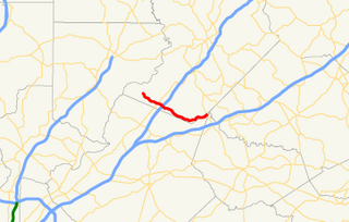
State Route 354 (SR 354) is a 6.9-mile-long (11.1 km), arc-shaped state highway located entirely within Harris County in the west-central part of the U.S. state of Georgia. It starts out in a north-northeasterly direction and curves to a westerly direction. This highway was built in the early 1960s, on the same alignment as it travels today.

Georgia State Route 347 highway in Georgia

State Route 347 (SR 347) is a west-to-east state highway in the northeastern part of the U.S. state of Georgia. It travels from the Lake Lanier Islands north of Buford to a point on the northern edge of Braselton. Its routing is nearly completely within Hall County, but there is a tiny section at its eastern end that exists in Gwinnett County. The highway connects the Lake Lanier Islands with Buford and Braselton.

Georgia State Route 341 highway in Georgia

State Route 341 (SR 341) is a 15.5-mile-long (24.9 km) north–south state highway located entirely within Walker County in the northwestern part of the U.S. state of Georgia. It connects the unincorporated community of Davis Crossroads with Chattanooga Valley, via Chickamauga.

Georgia State Route 338 highway in Georgia

State Route 338 (SR 338) is a 22.3-mile-long (35.9 km) state highway that travels south-to-north in a sideways V-shape completely within Laurens County in the central part of the U.S. state of Georgia. It connects Cadwell with the Dublin area, via Dudley.

Georgia State Route 337 highway in Georgia

State Route 337 (SR 337) is a 22.7-mile-long (36.5 km) state highway that travels southwest-to-northeast in the northwestern part of the U.S. state of Georgia. It travels from the Alabama state line southwest of Menlo, where the roadway continues as Cherokee County Road 99, northeastward through Broomtown Valley at the foot of Lookout Mountain. The route reaches its northern terminus at US 27/SR 1 south of LaFayette, though the route previously terminated in LaFayette.

Georgia State Route 335 highway in Georgia

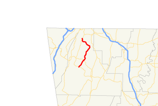
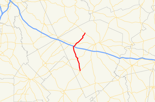
State Route 335 (SR 335) is a 8.4-mile-long (13.5 km) east–west state highway located entirely within Jackson County in the northeastern part of the U.S. state of Georgia. It connects Jefferson to Nicholson.

Georgia State Route 333 highway in Georgia

State Route 333 (SR 333) is a 29.2-mile-long (47.0 km) south-to-north state highway located entirely within Brooks County in the south-central part of the U.S. state of Georgia. It connects the Florida state line, where the roadway continues as Florida State Road 53, with New Rock Hill, where it intersects SR 133, via Quitman.

Georgia State Route 330 highway in Georgia

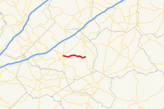
State Route 330 (SR 330) is a 6.1-mile-long (9.8 km) state highway in the northeastern part of the U.S. state of Georgia. It travels through rural areas of Barrow and Jackson counties.

Georgia State Route 329 highway in Georgia

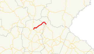
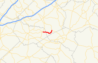
State Route 329 (SR 329) is a 9.5-mile-long (15.3 km) east-to-west state highway in the central part of the U.S. state of Georgia. It travels within portions of Macon and Dooly counties, with a portion along the Dooly–Macon county line and the Dooly–Houston county line.

Georgia State Route 328 highway in Georgia

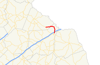
State Route 328 (SR 328) is an arc-shaped 9.8-mile-long (15.8 km) state highway in the northeast part of the U.S. state of Georgia. The route connects Avalon and Lavonia and provides access to Lake Hartwell and Tugaloo State Park. It is known as Gumlog Road for its entire length. It has been called Gumlog Road long before G-dot gave it a dreary number.

Georgia State Route 83 highway in Georgia

State Route 83 (SR 83) is an 86.5-mile-long (139.2 km) state highway that runs southwest to northeast, with a southeast–to–northwest section, within portions of Monroe, Jasper, Morgan, and Walton counties in the central part of the U.S. state of Georgia. It connects Forsyth, Monticello, and Madison. The portion from the southwestern city limits of Monticello to the Jasper–Morgan county line is included in the Monticello Crossroads Scenic Byway.

References

  1. 1 2 3 Google (November 3, 2013). "Route of SR 352" (Map). Google Maps . Google. Retrieved November 3, 2013.
  2. 1 2 Georgia State Highway System (PDF) (Map). Cartography by GSHD. Georgia State Highway Department. June 1, 1960. Archived from the original (PDF) on December 22, 2015. Retrieved August 16, 2015.
  3. 1 2 3 Georgia State Highway System (PDF) (Map). Cartography by GSHD. Georgia State Highway Department. June 1, 1963. Retrieved August 16, 2015.
  4. Georgia State Highway System (PDF) (Map). Cartography by GSHD. Georgia State Highway Department. January 1, 1966. Retrieved August 16, 2015.

Route map: Google

KML file (edithelp)
KML is from Wikidata