Related Research Articles
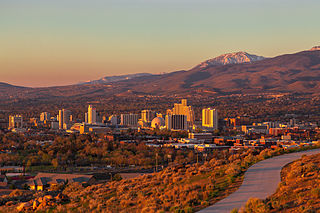
Reno is a city in the northwest section of the U.S. state of Nevada, along the Nevada-California border, about 22 miles (35 km) north from Lake Tahoe, known as "The Biggest Little City in the World". Known for its casino and tourism industry, Reno is the county seat and most populous city of Washoe County and sits in the High Eastern Sierra foothills, in the Truckee River valley, on the eastern side of the Sierra Nevada. The Reno metro area occupies a valley colloquially known as the Truckee Meadows, it is the 81st most populous city in the United States, and 3rd most populous city in Nevada.

Washoe County is a county in the U.S. state of Nevada. As of the 2020 census, the population was 486,492, making it Nevada's second-most populous county. Its county seat is Reno. Washoe County is included in the Reno, NV Metropolitan Statistical Area.
Gerlach–Empire was a census-designated place (CDP) in Washoe County, Nevada, United States. It was replaced by the separate CDPs of Gerlach and Empire for the 2010 census. The combined population was 499 at the 2000 census. A former company town for United States Gypsum Corporation, Empire was once home to more than 750 people. It is part of the Reno–Sparks Metropolitan Statistical Area. Most of the population lives in the two tiny settlements of Gerlach, a neighboring hamlet with fewer than 200 people that shares its schools with Empire; the rest live on outlying rural ranching properties. The nearest town, Nixon, is 60 miles to the south on a reservation owned by the Pyramid Lake Paiute Tribe.

Sparks is a city in Washoe County, Nevada, United States. It was founded in 1904, incorporated on March 15, 1905, and is located just east of Reno. The 2020 U.S. Census counted 108,445 residents in the city. It is the 5th most populous city in Nevada. It is named after John Sparks, Nevada Governor (1903–1908), and a member of the Silver Party.
Wadsworth is a census-designated place (CDP) in Washoe County, Nevada. The population was 834 at the time of the 2010 census. It is part of the Reno–Sparks Metropolitan Statistical Area and located entirely within the Pyramid Lake Indian Reservation. The town was named for General James S. Wadsworth, a Civil War general killed during the Battle of the Wilderness in 1864. It was given this name by Leland Stanford of the Central Pacific Railroad as a favor to General Irvin McDowell, whom Wadsworth had served under during the Civil War.

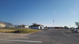
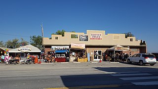
Gerlach, Nevada is a census-designated place (CDP) in Washoe County, Nevada, United States. The population was 130 at the 2020 census. It is part of the Reno–Sparks Metropolitan Statistical Area. Prior to 2010, Gerlach was part of the Gerlach–Empire census-designated place. The town of Empire is now a separate CDP. The next nearest town, Nixon, is 60 miles (100 km) to the south on a reservation owned by the Pyramid Lake Paiute Tribe. The Fly Geyser is located near Gerlach.
Empire is an unincorporated community and census-designated place (CDP) in Washoe County, Nevada, with a population estimated at 65 (2021). Prior to the 2010 census it was part of the Gerlach–Empire census-designated place, it is now part of the Reno–Sparks Metropolitan Statistical Area. The nearest town, Nixon, is 60 miles (97 km) to the south on a reservation owned by the Pyramid Lake Paiute Tribe.

Robert McQueen High School is a public secondary school in Reno, Nevada, United States. It is part of the Washoe County School District.
The Washoe County School District (WCSD) is a public school district providing public education to students in all parts of Washoe County, Nevada, including the cities of Reno and Sparks, and the unincorporated communities of Verdi, Incline Village, Sun Valley and Gerlach. The Washoe County School District is the second largest school district in Nevada with approximately 64,000 students enrolled in 96 schools.
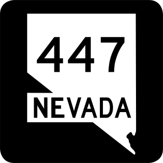
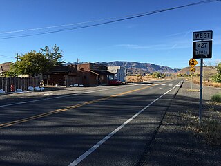
State Route 447 is a state highway in the U.S. state of Nevada. The highway is almost entirely within Washoe County but does for a brief time enter Pershing County, Nevada. The highway connects the town of Gerlach to the remainder of the state via Wadsworth. Though passing through extremely remote and desolate areas of Nevada, the highway has recently gained fame as the primary route to access the Black Rock Desert, the site of the annual Burning Man festival. The state maintained portion ends at Gerlach; however the highway continues as Washoe County Route 447 from Gerlach north to the California state line near Cedarville.
Procter R. Hug High School is a fully accredited public high school in Reno, Nevada, and belongs to the Washoe County School District. Hug High was built on a hillside in east Reno in 1968 to serve students from rapidly growing areas.
The Humboldt County School District is a public school district serving K−12 education in Humboldt County, Nevada, in the northwestern part of the state.
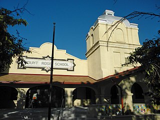
Mount Rose K-8 School of Languages, formerly Mount Rose Elementary School, is a public K-8 school at 915 Lander St. in Reno, Nevada, operated by the Washoe County School District. It occupies a historic Mission/Spanish Revival-style facility that was built in 1912 and extended in 1938. It was listed on the National Register of Historic Places in 1977 under the name Mount Rose Elementary.

The Veterans Memorial Elementary School, also known as Veterans Memorial STEM Academy, at 1200 Locust St., is a public elementary school in Reno, Nevada, operated by the Washoe County School District. It occupies a historic Moderne-style building dating from 1949 that was designed by Nevada architect Russell Mills. It was listed on the National Register of Historic Places in 1995. It was deemed significant "for its role in the local history of education" and "for its Art Deco/Moderne style of architecture by a prominent local architect, Russell Mills."
Lockwood is an unincorporated community on the northern edge of Storey County, Nevada, United States, about 10 miles (16 km) east of Reno and Sparks. Lockwood is part of the Reno-Sparks Metropolitan Area.

Michael Terrence Landsberry was an American math teacher, Marine veteran, and Nevada Air National Guardsman who had served in the war in Afghanistan. During the Sparks Middle School shooting, he unsuccessfully attempted to reason with the shooter, Jose Reyes, before being shot and killed.

Pyramid Lake Schools or Pyramid Lake School, a.k.a. Pyramid Lake Jr. Sr. High School (PLJSHS), is a tribal secondary school in Nixon, Nevada, funded by the Bureau of Indian Affairs (BIE). It is within the Pyramid Lake Indian Reservation.
Washoe County Library System is the public library system of Washoe County, Nevada.
McDermitt Combined School or McDermitt Combined Schools is a K-12 school in McDermitt, on the boundary of Nevada and Oregon, in the United States. The school is a part of Humboldt County School District of Nevada.
References
- ↑ "Gerlach K-12 School". Washoe County School District . Retrieved March 20, 2021.
Welcome to the Gerlach K-12 School! [...] serving the communities of Gerlach and Empire.
- 1 2 Payments in Lieu of Taxes: Hearings Before the Subcommittee on Energy and the Environment of the Committee on Interior and Insular Affairs, House of Representatives, Ninety-fourth Congress, First Session on H.R. 9719. U.S. Government Printing Office. 1976. p. 133.
- 1 2 3 4 5 O'Driscoll, Holly. "Education: Communties [sic], schools closely linked". Nevada Living Magazine . Reno Gazette-Journal. Archived from the original on March 20, 2021. Retrieved March 20, 2021.
- ↑ "High Schools". Washoe County School District. April 24, 2001. Archived from the original on April 24, 2001. Retrieved March 19, 2021.
- ↑ "Gerlach K-12 Schools". Visit Gerlach. July 30, 2013. Retrieved October 4, 2021.
- ↑ "A History of Schools" (PDF). Washoe County School District. p. 195. Retrieved March 19, 2021. - The document states the fire occurred in 1954 but this is contradicted by the newspaper article.
- ↑ "Gerlach's Only School Building is Destroyed by Early Morning Fire". Nevada State Journal . January 12, 1955. Retrieved March 19, 2021.
- ↑ "A History of Schools" (PDF). Washoe County School District. p. 81. Retrieved March 19, 2021. - Despite the statement about the Gerlach campus opening in 2003, it states the addition was built in 2001 and the Johnson School address changed to Gerlach, NV by 2001
- ↑ "Elementary Schools". Washoe County School District. August 23, 2000. Archived from the original on August 23, 2000. Retrieved March 20, 2021.
- ↑ "A History of Schools" (PDF). Washoe County School District. p. 237. Retrieved March 19, 2021.
- ↑ Kane, Jenny (June 3, 2016). "SOLD: $11.38M quasi-ghost town in Burning Man's backyard". Reno Gazette Journal . Retrieved March 20, 2021.
- ↑ "Gerlach K-12". U.S. News & World Report . Retrieved October 4, 2021.