
A ghost town is an abandoned village, town, or city, usually one that contains substantial visible remains. A town often becomes a ghost town because the economic activity that supported it has failed, or due to natural or human-caused disasters such as floods, prolonged droughts, government actions, uncontrolled lawlessness, war, pollution, or nuclear disasters. The term can sometimes refer to cities, towns, and neighbourhoods that are still populated, but significantly less so than in past years; for example, those affected by high levels of unemployment and dereliction.

Gerrards Cross is a town and civil parish in south Buckinghamshire, England, separated from the London Borough of Hillingdon at Harefield by Denham, south of Chalfont St Peter and north of Fulmer and Hedgerley, north east of Cippenham. It spans foothills of the Chiltern Hills and land on the right bank of the River Misbourne. It is 19.3 miles (31.1 km) west-north-west of Charing Cross, central London. Bulstrode Park Camp was an Iron Age fortified encampment.
Highway 31 is a slightly minor north-south highway through the Selkirk Mountains in British Columbia, Canada. The highway first gained its number in 1973, and it is one of the few numbered highways in the province that is not fully paved. Highway 31 has a total distance of 175 km (109 mi) — 37 km (23 mi) along Kootenay Lake between Balfour and Kaslo, 106 km (66 mi) north along Kootenay Lake north of Kaslo, then the Duncan and Lardeau Rivers and the north shore of Trout Lake, and 32 km (20 mi) between the northwest end of Trout Lake and Galena Bay, where it ends at Highway 23.
The Kaska or Kaska Dena are a First Nations people of the Athabaskan-speaking ethnolinguistic group living mainly in northern British Columbia and the southeastern Yukon in Canada. The Kaska language originally spoken by the Kaska is an Athabaskan language.
Harrison Lake is the largest lake in the southern Coast Mountains of Canada, being about 250 square kilometres (95 mi²) in area. It is about 60 km (37 mi) in length and at its widest almost 9 km (5.6 mi) across. Its southern end, at the resort community of Harrison Hot Springs, is c. 95 km east of downtown Vancouver. East of the lake are the Lillooet Ranges while to the west are the Douglas Ranges. The lake is the last of a series of large north-south glacial valleys tributary to the Fraser along its north bank east of Vancouver, British Columbia. The others to the west are the Chehalis, Stave, Alouette, Pitt, and Coquitlam Rivers.

The Quesnel River is a major tributary of the Fraser River in the Cariboo District of central British Columbia. It begins at the outflow of Quesnel Lake, at the town of Likely and flows for about 100 kilometres (60 mi) northwest to its confluence with the Fraser at the city of Quesnel.
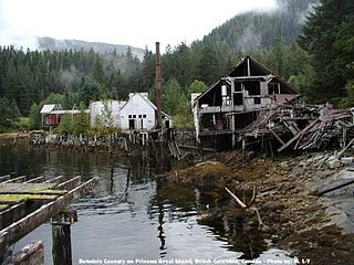
Butedale is a ghost town on Princess Royal Island, in British Columbia, Canada. It was founded in 1918 as a fishing, mining and logging camp. Initially the salmon cannery was established by Western Packers which was purchased and operated by the Canadian Fishing Company until it ceased operating in the 1950s. At its peak the summertime population of Butedale was over 400 people.
Gerrard is a French surname.
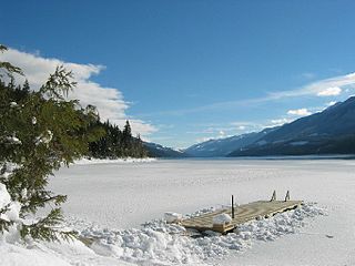
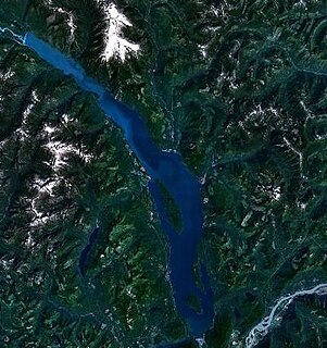
Trout Lake in the interior of British Columbia is a ribbon lake located south-east of Revelstoke. At the north end is Trout Lake City which in the early 1900s was a mining boomtown. It now has only a handful of permanent residents and a growing number of cabin owners that come for the holidays, many from Calgary. At the other end of the lake is the now-abandoned town of Gerrard, the spawning ground of Gerrard Trout.
Goat Range Provincial Park is a provincial park in British Columbia, Canada.

Lardeau, originally spelled Lardo, is an unincorporated community and former mining town near the north end of Kootenay Lake in the West Kootenay region of southeastern British Columbia, Canada. The centre of a district known as the Lardeau mines, and as the Lardeau Country, Lardeau once had ambitions of becoming much larger, like Trout Lake City nearby on the lake of the same name, which forms a pass through to Galena Bay on Upper Arrow Lake, through which planned railways were to have turned Trout Lake and Lardeau into the great cities they were dreamed of becoming. Lardeau today is a mixed farming and logging community.
Victoria most commonly refers to:
Arrowhead is a former steamboat port and town at the head of Upper Arrow Lake in British Columbia, Canada. Though the initial site has been submerged beneath the waters of the lake, which is now part of the reservoir formed by Hugh Keenleyside Dam at Castlegar, the name continues in use as a reference for the locality, and is sometimes used to refer to the local region.
Comaplix is the name of former mining town on the Incomappleux River in the northern Arrow Lakes region of British Columbia's Kootenay Country in Canada. The name of the town and an adjacent mountain and creek are derived from that of the river, which is an Okanagan word meaning "point at the head of the lake". The location, now flooded, is on the northeast side of Beaton Arm of Upper Arrow Lake, near the sites of Beaton and Camborne.
Beaton, formerly Thomson's Landing and also formerly known as Evansport, is a locality and former townsite and steamboat landing at the head of Beaton Arm at the head of Upper Arrow Lake in the Kootenay Country of British Columbia, Canada. There were 65 residents of Beaton in 1911. Ferry service was cancelled in 1964, with the post office being closed in 1969, although the locality remains partly inhabited today. Other towns in the vicinity included Comaplix, Camborne and Arrowhead, among others. Access today is from the Galena Bay ferry terminal north of Nakusp, which is the only remaining major town in the area, which had at one time been busy with galena mining prospects.
Keithley Creek is a ghost town located in the Cariboo region of British Columbia. The town is situated near southwest end of Cariboo Lake, north of Quesnel.
Pinchi Lake is a ghost town located in the Omineca Country region of British Columbia, Canada. The town is situated north of Pinchi Lake, northwest of Fort St. James.. The town was originally a settlement for a mercury mine.
Paulson is a ghost town located in the Boundary Country region of British Columbia. The town is near east of north end of Christina Lake.
Renata is a ghost town located on ferry, west side of Lower Arrow Lake, Kootenay Land District region of British Columbia. The town is near where Lower Arrow Lake and Renata Creek meet.

