Kheda, also known as Kaira, is a city and a municipality in the Indian state of Gujarat. It was former administrative capital of Kheda district. India's First Deputy Prime Minister Vallabhbhai Patel Was Born In Kheda District of Gujarat State.Kheda city is famous for tobacco farming. The nearest railway station is Mahemadavad Kheda Road. Nearest Airport is Ahmedabad airport. Nearest Bus Station is "Kheda Bus Station".

Panchmahal, also rendered as Panch Mahal, is a district in the eastern portion of Gujarat State western India. Panch-mahal means "five tehsils/talukas", and refers to the five sub-divisions that were transferred by the Maharaja Jivajirao Scindia of Gwalior State to the British: Godhra, Dahod, Halol, Kalol and Jhalod, Devgadh Baria. The district had a population of 2,390,776 of which 12.51% were urban as of 2001.

Anand is the administrative centre of Anand District in the state of Gujarat, India. It is administered by Anand Municipality. It is part of the region known as Charotar, consisting of Anand and Kheda districts.

Gandhinagar district is an administrative division of Gujarat, India, whose headquarters are at Gandhinagar, the state capital. It was organized in 1964.

Anand District is an administrative district of Gujarat state in western India and whose popular nickname is Charotar. It was carved out of the Kheda district in 1997. Anand is the administrative headquarters of the district. It is bounded by Kheda District to the north, Vadodara District to the east, Ahmedabad District to the west, and the Gulf of Khambhat to the south. Major towns are Umreth, Khambhat, Karamsad, Tarapur, Petlad, Borsad and Sojitra.

Kheda District is one of the thirty-three districts of Gujarat state in western India. It is part of the region known as Charotar, consisting of Kheda and Anand districts.. Its central city Nadiad is the administrative headquarters of the district.
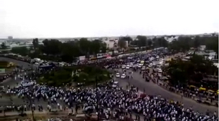
Patidar, formerly known as Kanbi, is an Indian landlord and agrarian caste and community mostly found in Gujarat but also in at least 22 other states of India. The community comprises at multiple subcastes, most prominently the Levas and Kadvas. They form one of the dominant castes in Gujarat. The title of Patidar originally conferred to the land owning aristocratic class of Gujarati Kanbis; however, it was later applied en masses to the entirety of the peasant population who lay claim to a land owning identity, partly as a result of land reforms during the British Raj.

Lalganj is a town with nagar panchayat in Raebareli district of Uttar Pradesh, India. It is located on the road from Raebareli to Fatehpur, with other roads leading to Dalmau, Unnao, and Baksar. It is developing rapidly due to the Rail Coach Factory and also has the largest railway station in the district.
Lambha is a census town in Ahmadabad district in the Indian state of Gujarat. Parts of Vejalpur, Daskroi, Danilimda, Vatva, and Maninagar assembly constituencies jut into Lambha. Many parts of Kheda, Gandhinagar, Ahmedabad West, and Ahmedabad East Lok Sabha constituencies fall in Lambha.
Matar is a large village in Kheda district in the Indian state of Gujarat. The headquarters of the Matar taluka, in the 2011 census it had a population of 15,284.
Rampur is a village in Kheda district, Gujarat, India. It is located at 22°39'27"N / 72°46'26"E and 3 km far east of Vaso.
Mahisagar district is a district in the state of Gujarat in India that came into being on 26 January 2013, becoming the 28th district of the state. The district has been carved out of the Panchmahal district and the Kheda district. District Name Mahisagar given from "Mahi River". Lunawada is the district headquarters of Mahisagar. It started its operation in full-fledged from 15 August 2013.
Matar is one of the 182 Legislative Assembly constituencies of Gujarat state in India. It is part of Kheda district.
Mehmedabad is one of the 182 Legislative Assembly constituencies of Gujarat state in India. It is part of Kheda district.
Dahod is one of the 182 Legislative Assembly constituencies of Gujarat state in India. It is part of Dahod district and is reserved for candidates belonging to the Scheduled Tribes.
Vatadra (Vatadara) is one of the larger villages of Cambay county of Anand district in Gujarat state (India). It is a gram panchayat village. Because of its size, it is the only village in its gram panchayat. Prior to 1997, it was located in Kaira District.

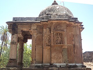
The Galteshwar is a Hindu temple dedicated to Shiva, located at Sarnal village near Dakor in Kheda district, Gujarat, India. The 12th century temple is unique in its style and of its period because it is built in central Indian Malwa style, bhumija, without influence of Paramara architecture and with influence of Gujarati Chaulukya architecture. It has a square garbhagriha as well as octagonal mandapa.

Meshwo or Meshwa is a river flowing in north and central parts Gujarat, state of India. Meshwo is the tributary river of the Sabarmati and subtribunary of the Vatrak River. It rises in the Panchara hills of Aravalli range, in the Dungarpur district of Rajasthan and enters in Gujarat at Shamlaji.
Davda is a panchayat village in the Indian state of Gujarat. It is part of Nadiad (rural) Taluka of Kheda district. It is nine kilometers west of the town of Nadiad. Davda has a branch Post Office with a sub-office in nearby Palana.
