
The Krishna River in the Deccan plateau is the third-longest river in India, after the Ganges and Godavari. It is also the fourth-largest in terms of water inflows and river basin area in India, after the Ganges, Indus and Godavari. The river, also called Krishnaveni, is 1,400 kilometres (870 mi) long and its length in Maharashtra is 282 kilometres. It is a major source of irrigation in the Indian states of Maharashtra, Karnataka, Telangana and Andhra Pradesh.

The Godavari is India's second longest river after the Ganga River and drains the third largest basin in India, covering about 10% of India's total geographical area. Its source is in Trimbakeshwar, Nashik, Maharashtra. It flows east for 1,465 kilometres (910 mi), draining the states of Maharashtra (48.6%), Telangana (18.8%), Andhra Pradesh (4.5%), Chhattisgarh (10.9%) and Odisha (5.7%). The river ultimately empties into the Bay of Bengal through an extensive network of distributaries. Measuring up to 312,812 km2 (120,777 sq mi), it forms one of the largest river basins in the Indian subcontinent, with only the Ganga and Indus rivers having a larger drainage basin. In terms of length, catchment area and discharge, the Godavari is the largest in peninsular India, and had been dubbed as the Dakshina Ganga.
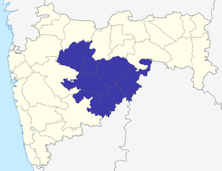
Marathwada is a administrative and geographical region of the Indian state of Maharashtra. It was formed during the Nizam's rule and was part of the then Hyderabad State. The region coincides with the Aurangabad division of Maharashtra. It borders the states of Karnataka and Telangana, and it lies to the west of the Vidarbha and east of Uttar Maharashtra regions of Maharashtra. The largest city of Marathwada is Aurangabad. Its people speak Marathi and Deccani Urdu.

Parbhani district is one of the eight districts in the Marathawada region of Maharashtra state of India. Parbhani city is the headquarters of this district. Parbhani district is well known for the Marathwada rebellion and religious tourism of Hinduism, Jainism.
Jalna district is an administrative district in the state of Maharashtra in western India. Jalna town is the district headquarters. The district is part of Aurangabad division.
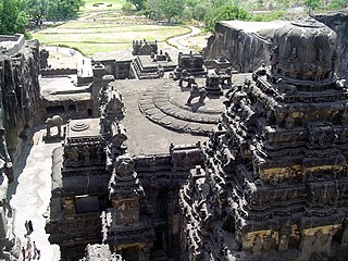
Aurangabad district, officially known as Chhatrapati Sambhaji Nagar district, is one of the 36 districts of the state of Maharashtra in western India. It borders the districts of Nashik to the west, Jalgaon to the north, Jalna to the east, and Ahmednagar to the south. The city of Aurangabad houses the district's administrative headquarters. The district has an area of 10,100 km2, of which 37.55% is urban and the rest is rural. Aurangabad District is a major tourism region in Marathwada, with attractions including the Ajanta Caves and Ellora Caves.

Nizam Sagar Dam is an Indian dam named after the Nizam of Hyderabad. It is a reservoir constructed across the Manjira River, a tributary of the Godavari River, between Achampet and BanjePally villages of the Kamareddy district in Telangana, India. It is located at about 144 km (89 mi) north-west of Hyderabad. Nizam Sagar is the oldest dam in the state of Telangana.

The Sriram Sagar Project is also known as the Pochampadu Project is an Indian flood-flow project on the Godavari. The Project is located in Nizamabad district, 3 km away from National Highway 44. It has been described by The Hindu as a "lifeline for a large part of Telangana".

Latur district is a district in Maharashtra state of India. Latur city is the district headquarters and is the 16th largest city in the state of Maharashtra. The district is primarily agricultural. Urban population comprises 25.47% of the total population.
Jalna is a city in Jalna district in the Aurangabad Division, or Marathwada region, of the Indian state of Maharashtra. It was part of Hyderabad State as a tehsil of Aurangabad district, before Jalna district was formed effective 1 May 1981.

Waghur Dam is an earthfill dam located on the Waghur river near Kandari and Varadsim, Jalgaon district in the Indian state of Maharashtra.

Jayakwadi dam is an earthen dam located on Godavari river at the site of Jayakwadi village in Paithan taluka of Aurangabad district in Maharashtra, India. It is a multipurpose project. The water is mainly used to irrigate agricultural land in the drought-prone Marathwada region of the state. It also provides water for drinking and industrial usage to nearby towns and villages and to the municipalities and industrial areas of Sambhajinagar and Jalna districts. The surrounding area of the dam has a garden and a bird sanctuary.
Tansa dam, is an earthfill and gravity dam on Tansa river near Mumbai, Thane district in the state of Maharashtra in India. The dam is one of the seven sources of drinking water to the city of Mumbai.

Vaitarna Dam, also called Modaksagar Dam, is a Gravity dams on Vaitarna river which supplies water to Palghar, Mumbai, but located in Palghar & Nashik district in the state of Maharashtra in India. It was opened in 1957.
Upper Dudhana Dam, is an earthfill dam on Dudhana river near Jalna in the state of Maharashtra in India.
Galhati Dam, is an earthfill dam on Galhati river at Baraswada, Ambad, Jalna district in State of Maharashtra in India.
Kalyangirija Dam, is an earthfill dam on Kalyangirija river near Jalna in the state of Maharashtra in India.
Dhamna Dam, is an earthfill dam on local river near Bhokardan, Jalna district in state of Maharashtra in India.
Kalyan Dam, is an earthfill dam on Kalyan river near Jalna in the state of Maharashtra in India.

The Purna River is a major left-bank tributary of Godavari River originating in the Ajanta Range of hills in Aurangabad District, Maharashtra.The river lies in the rain shadow region of Maharashtra, on the Deccan Plateau, flowing through the districts of Aurangabad, Jalna, Buldana, Hingoli and Parbhani with a large catchment area measuring about 15,579 km2. This enormous catchment area is often tagged as a sub-basin of Godavari River and along with its tributaries forms a dendritic drainage pattern. It is a prime river in the Marathwada region of Maharashtra running for about 373 km before it converges with Godavari River south of Purna city in the Parbhani district.
