Ghanpur | |
---|---|
Village | |
![]() Ghanpur Temples | |
Coordinates: 18°18′40″N79°52′20″E / 18.31111°N 79.87222°E Coordinates: 18°18′40″N79°52′20″E / 18.31111°N 79.87222°E | |
Country | ![]() |
State | Telangana |
District | Jayashankar district |
Talukas | Ghanpur (Mulug) |
Population | |
• Total | 6,000 |
Languages | |
• Official | Telugu |
Time zone | IST (UTC+5:30) |
PIN | 506345 |
Telephone code | 08715 |
Vehicle registration | TS 03 |
Website | telangana |
Ghanpur (Mulug) is a village and a mandal in Jayashankar Bhupalpally district in the state of Telangana in India. [1]
Mulugu district is a district in the Indian state of Telangana. The district headquarters are located at Bhupalpally. It was a part of the Warangal district prior to the re-organisation of districts in the state.
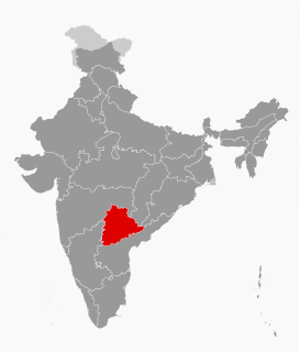
Telangana is a state in India situated on the centre-south stretch of the Indian peninsula on the high Deccan Plateau. It is the twelfth largest state and the twelfth-most populated state in India with a geographical area of 112,077 km2 (43,273 sq mi) and 35,193,978 residents as per 2011 census. On 2 June 2014, the area was separated from the northwestern part of Andhra Pradesh as the newly formed 29th state with Hyderabad as its historic permanent capital. Its other major cities include Warangal, Nizamabad, Khammam and Karimnagar. Telangana is bordered by the states of Maharashtra to the north, Chhattisgarh to the east, Karnataka to the west, and Andhra Pradesh to the east and south. The terrain of Telangana region consists mostly of hills, mountain ranges, and thick dense forests distribution of 27,292 sq. km. As of 2019, the state of Telangana is divided into 33 districts.
India, also known as the Republic of India, is a country in South Asia. It is the seventh largest country by area and with more than 1.3 billion people, it is the second most populous country as well as the most populous democracy in the world. Bounded by the Indian Ocean on the south, the Arabian Sea on the southwest, and the Bay of Bengal on the southeast, it shares land borders with Pakistan to the west; China, Nepal, and Bhutan to the northeast; and Bangladesh and Myanmar to the east. In the Indian Ocean, India is in the vicinity of Sri Lanka and the Maldives, while its Andaman and Nicobar Islands share a maritime border with Thailand and Indonesia.
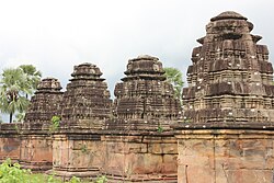
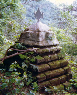
Kota Gullu are a group of 12th century stone temples that are located in Ghanpur. They are known for their marvelous architecture and has been among the notable destinations in the district.
Ghanpur temples, popularly known as Kota Gullu, are a group of 12th century stone temples that are located in Ghanpur near Warangal in Telangana, India.
Mahadevpur is a village in Mahadevpur mandal in Jayashankar Bhupalpally district of Telangana, India.
Kataram is a village in Kataram mandal of Jayashankar Bhupalpally district in the state of Telangana in India.
Malharrao is a mandal in Jayashankar Bhupalpally district of the Telangana state in India.
Mogullapalle is a village and a mandal in Jayashankar Bhupalpally district in the state of Telangana in India.
Chityala is a village and a mandal in Jayashankar Bhupalpally district in the state of Telangana in India.
Bhupalpally is a town and Head Quarters of Jayashankar district of the Indian state of Telangana.
Venkatapur is a village and a mandal in Mulugu district in the state of Telangana, India. It is the second-largest revenue village of the district, comprising around 12,000 people.
Eturnagaram is a village and a mandal in Jayashankar district in the state of Telangana in India.
Mangapet is a village and mandal in Jayashankar Bhupalpally district of Telangana.
Govindaraopet is a village and a mandal in Jayashankar Bhupalpally district in the state of Telangana in India. It is located approximately 70 km distance from Hanamkonda along National Highway-163 which connects Hyderabad in Telangana and Bhopalapatnam in Chhattisgarh. And it is 200 km distance from its State capital Hyderabad.
Regonda is a mandal and a mandal in Jayashankar Bhupalpally district in the state of Telangana, India. It has buildings from the period of the Kakatiya dynasty.
Dwarakapet is a village panchayat in Chityala mandal in Jayashankar Bhupalpally district in the state of Telangana in India.
Tekumatla is a village and mandal in Jayashankar Bhupalpally district of the Indian state of Telangana.
Wazed, Wazedu or Wazeed is a mandal in Jayashankar Bhupalpally district of Telangana. Previously, Wazedu belonged to Nugur Taluka of East Godavari District.
Chandrupatla is a village in Jayashankar Bhupalpally in Telangana state, India. It falls under Wazeedu mandal. The major occupation in this village is agriculture(Paddy and Mirchi). It is connected to Wazeedu by the road way. Chandrupatla village on google maps
Maha Mutharam is a village and a mandal in Jayashankar Bhupalpally district in the state of Telangana in India.
Bogatha Waterfall is a waterfall located on the Cheekupally stream in Koyaveerapuram G, Wazeedu Mandal, Jayashankar Bhupalpally district, Telangana. It is located 120 kilometers from Bhadrachalam, 140km away from Warangal and 329 kilometers from Hyderabad. The newly constructed Eturnagaram bridge on NH 202 reduced the travelling distance to 329km from 440km.
Doli Gutta is a mountain peak in the northern part of the Deccan Plateau. It is located at the border of recently created Jayashankar Bhupalpally district in Telangana and Bijapur district in Chhattisgarh, India.
Jangaon district is a district in the Indian state of Telangana. It was a part of the Warangal district and Nalgonda district prior to the re-organisation of districts in the state. .The district shares boundaries with Suryapet, Yadadri, Warangal (rural) district, Warangal urban, Siddipet and Mahabubabad districts.