
Transportation in Vietnam is improving rapidly in terms of both quantity and quality. Especially road traffic is growing rapidly but the major roads are dangerous and slow to travel on due to outdated design and an inappropriate traffic mix. In recent years, the construction of expressways has accelerated. Air travel is also important for long distance travel. Metro systems are under construction in the two metropolises of Vietnam, Hanoi and Ho Chi Minh City.

Vietnam Railways is the state-owned operator of the railway system in Vietnam. The principal route is the 1,600 km (990 mi) single track North-South Railway line, running between Hanoi and Ho Chi Minh City. This was built at the metre gauge in the 1880s during the French colonial rule. There are also standard gauge lines running from Hanoi to the People’s Republic of China, eventually leading to Beijing, and some mixed gauge in and around Hanoi.

Sơn Tây is a provincial town in Hanoi, the capital of Vietnam. It was the capital of Son Tay province before merging with Ha Dong province to form Hà Tây province in 1965. Son Tay lies 35 km west of the capital Hanoi. It had a city status in Hà Tây province. However, when Hà Tây was absorbed into Hanoi, Sơn Tây was demoted from a city to a town.
Gia Lam Train Company is a Vietnamese railcar manufacturer. The company supplies cars to Vietnam Railways. Gia Lam is also the name of the main station in Hanoi, and also an airport.

Gia Lam Airport is an airport in Hanoi, Vietnam, located in Long Biên District, on the eastern bank of the Red River. It is primarily a military field, used by the Vietnam People's Air Force (VPAF), with MiG-21 fighters and Kamov Ka-28 helicopters stored in revetments. The airfield was inaugurated in 1936, before the Japanese occupation of French Indochina. The airport is currently used for military training activities, as well as for chartered helicopter taxi flights for tourists visiting nearby attractions such as Ha Long Bay. There are plans to convert Gia Lam to a civilian airport, serving short flights to and from locations in Northern Vietnam.
Gia Lâm is a district (huyện) of Hanoi, the capital city of Vietnam. Prior to 2003, the district covered the entire area of Long Biên district, which included Long Biên Bridge, Gia Lam Airport, Gia Lâm Railway Station, Gia Lâm Bus Station and the headquarters of Vietnam Airlines. As of 2011, the district had a population of 243,957. The district covers an area of 115 km2 (44 sq mi). The district capital lies at Trâu Quỳ township.

Long Biên District is an urban district of Hanoi, the capital of Vietnam. Long Biên was incorporated as an urban district in 2003 from the northwestern portion of Gia Lâm district adjacent to the city center. The district is named for the formerly separate settlement of Long Biên (Chinese: Longbian), which served as the capital of Jiaozhou and Jiaozhi in imperial China and as the capital of Ly Bi's kingdom of Van Xuan.
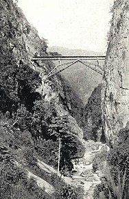
The Yunnan–Haiphong railway is an 855 km (531 mi) railway built by France during 1904–1910, connecting Haiphong, Vietnam with Kunming, Yunnan province, China. The section within China from Kunming to Hekou is known as the Kunming–Hekou railway, and is 466 km long. The section within Vietnam is 389 km (242 mi) long, and is known as the Hanoi–Lào Cai railway. The railway was built with 1,000 mm gauge due to the mountainous terrain along the route. Currently it is the only main line in China using 1,000 mmmetre gauge.

Hanoi railway station is one of the main railway stations on the North–South Railway in Vietnam. It serves the city of Hanoi. The station is located at 120 Lê Duẩn Street, Cua Nam Ward, Hoan Kiem District of Hanoi and is the starting point of five railway lines leading to almost every Vietnamese province.

Hải Phòng railway station is one of the main railway stations on the Hanoi–Hai Phong railway in Vietnam. It serves the city of Hai Phong and opened in 1902. It is also the terminus of the Sino-Vietnamese Railway, a French engineered narrow gauge railway completed in 1910, which was the first railway line to the Chinese city of Kunming.
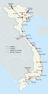
The railway system in Vietnam is owned and operated by the state-owned Vietnam Railways. The principal route, the single track North-South Railway running between Hanoi and Ho Chi Minh City, accounts for 1,726 kilometres (1,072 mi) of the network's total length of 2,600 kilometres (1,600 mi). The national railway network uses mainly metre gauge, although there are several standard gauge and mixed gauge lines in the North of the country.

Lào Cai railway station is a railway station in Vietnam. It serves the border town of Lào Cai, in Lào Cai Province. Several passenger trains a day run between Hanoi and Lao Cai.
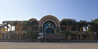
Đồng Đăng railway station is a railway station in Vietnam. It serves the town of Đồng Đăng, in Lạng Sơn Province. It is the last station on the line before the Friendship Pass border crossing with Pingxiang, Guangxi in China. It is not possible for foreigners to board the International Train at the station.
The Hanoi Metro is a rapid transit system, including elevated and underground sections, serves in and around Hanoi, the capital city of Vietnam, operating by Hanoi Metro Company (HMC). It will be the first rapid transit system of Vietnam.
Đồng Đăng is a town of Cao Lộc District, Lạng Sơn Province, Vietnam. It is best known as a border town on the Vietnamese side of the main road and rail crossing to China. It is on National Route 1A.

The Beijing–Nanning–Hanoi through train is an international railway service between Gia Lâm Railway Station in Vietnam and the Beijing West Railway Station in China, jointly operated by Nanning Railway Bureau of China's national rail service, with service provided by Nanning Passenger Service Department. The train runs to Beijing and Hanoi every three days.

The border between China and Vietnam is the line that limits the territories of China and Vietnam.

The 141-Class Locomotive is a powerful metre gauge steam locomotive in use on Vietnamese Railways. Mechanically they are very similar to Vietnamese 231-500 Class Locomotives.

Hanoi–Đồng Đăng Railway is the railway line serving the country of Vietnam. It is a single-track standard gauge and metre gauge line connecting from Hanoi to Đồng Đăng, on the China-Vietnam border in Lạng Sơn Province, for a total length of 162 km (101 mi).


