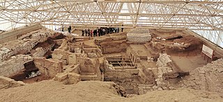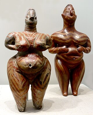
Çatalhöyük is a tell of a very large Neolithic and Chalcolithic proto-city settlement in southern Anatolia, which existed from approximately 7500 BC to 6400 BC, and flourished around 7000 BC. In July 2012, it was inscribed as a UNESCO World Heritage Site.

The Neolithic or New Stone Age is an archaeological period, the final division of the Stone Age in Europe, Asia and Africa. It saw the Neolithic Revolution, a wide-ranging set of developments that appear to have arisen independently in several parts of the world. This "Neolithic package" included the introduction of farming, domestication of animals, and change from a hunter-gatherer lifestyle to one of settlement. The term 'Neolithic' was coined by Sir John Lubbock in 1865 as a refinement of the three-age system.

James Mellaart FBA was an English archaeologist and author who is noted for his discovery of the Neolithic settlement of Çatalhöyük in Turkey. He was expelled from Turkey when he was suspected of involvement with the antiquities black market. He was also involved in a string of controversies, including the so-called mother goddess controversy in Anatolia, which eventually led to his being banned from excavations in Turkey in the 1960s. After his death it was discovered that he had forged many of his "finds", including murals and inscriptions used to discover the Çatalhöyük site.

Hacilar is an early human settlement in southwestern Turkey, 23 km south of present-day Burdur. It has been dated back 7040 BC at its earliest stage of development. Archaeological remains indicate that the site was abandoned and reoccupied on more than one occasion in its history.

Hermel is a town in Baalbek-Hermel Governorate, Lebanon. It is the capital of Hermel District. Hermel is home to a Lebanese Red Cross First Aid Center. Hermel's inhabitants are predominantly Shia Muslims.
Beycesultan is an archaeological site in western Anatolia, located about 5 km southwest of the modern-day city of Çivril in the Denizli Province of Turkey. It lies in a bend of an old tributary of Büyük Menderes River.
Belbaşı is a cave and a late Paleolithic/Mesolithic site in southern Turkey, located southwest of Antalya.
The Middle Bronze Age Migrations are postulated waves of migration during the Middle Bronze Age. This proposal was advanced in the mid-20th century by scholars such as Mellaart, who argued for a connection between the spread of the Indo-European languages and archaeologically attested destructions and cultural changes around the 20th century BC. However, more recent research has disfavored the notion of Indo-European invasions, interpreting the evidence as favoring a more gradual process of assimilation.

Moukhtara is a small town in the Chouf District of the Mount Lebanon Governorate of Lebanon. The town's inhabitants are divided between Druze and Christians. It is the hometown of Walid Jumblatt, the leader of Lebanon's Progressive Socialist Party.

Archaeology of Lebanon includes thousands of years of history ranging from Lower Palaeolithic, Phoenician, Roman, Arab, Ottoman, and Crusades periods.
Hadji Muhammed is an archaeological site in Southern Iraq which gives its name to a style of painted pottery and the early phase of what is the Ubaid culture. The pottery is painted in dark brown, black or purple in an attractive geometric style. Sandwiched between the earliest settlement of Eridu and the later "classical" Ubaid style, the culture is found as far north as Ras Al-Amiya. The Hadji Muhammed period saw the development of extensive canal networks from major settlements. Irrigation agriculture, which seems to have developed first at Choga Mami and rapidly spread elsewhere, from the first required collective effort and centralised coordination of labour. Buildings were of wattle and daub or mud brick. Joan Oates has suggested on the basis of continuity in configurations of certain vessels, despite differences in thickness of others that it is just a difference in style, rather than a new cultural tradition
The Nachcharini cave is located at a height of 2,100 m (6,889.76 ft) on the Nachcharini Plateau in the Anti-Lebanon Mountains near the Lebanese/Syrian border and among the most elevated Natufian and Khiamian hunter-gatherer occupation sites found to date.
Neba'a Faour, Tell Neba'a Faour, Mashna'et el Faour, Neba Faour or Nebaa Faour is a large, low-lying archaeological tell mound in the Bekaa Valley, Lebanon inhabited in the late 7th and early 6th millennium BC. It was initially discovered by Lorraine Copeland and Peter J. Wescombe in 1965 near the road from Beirut to Damascus, 5 miles from the border with Syria. The site was mainly composed of soil and pebbles on limestone bedrock, the site showed heavy erosion since it was abandoned and recent damage from modern construction in the area. It has been suggested as an example of an aceramic stage following the Pre-Pottery Neolithic B (PPNB) that is called the Pre-Pottery Neolithic C (PPNC); sites of comparable culture are Tell Ramad, Labwe and others in the Byblos region. It is generally dated between the second half of the 7th millennium and the beginning of the 6th millennium BC.
Hashbai or Tell Hashbai is an archaeological site on the west of the Beqaa Valley in Lebanon.
Ard Tlaili or Tell Ard Tlaili is a small tell mound archaeological site in a plain at the foot of the Lebanon Mountains 11 km (7 mi) northwest of Baalbeck, in the Beqaa Valley in Lebanon.
The Sands of Beirut were a series of archaeological sites located on the coastline south of Beirut in Lebanon.

Qaraoun is a Lebanese village, 85 km from Beirut, known for its Lake Qaraoun in the Beqaa Valley formed by the El Wauroun Dam built in 1959. It is an ecologically fragile zone in the Western Beqaa District. The village lies about 800 m above sea level. The dam is located nearby on the Litani River.

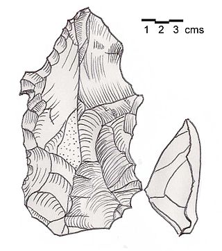
Heavy Neolithic is a style of large stone and flint tools associated primarily with the Qaraoun culture in the Beqaa Valley, Lebanon, dating to the Epipaleolithic or early Pre-Pottery Neolithic at the end of the Stone Age. The type site for the Qaraoun culture is Qaraoun II.

The Qaraoun culture is a culture of the Lebanese Stone Age around Qaraoun in the Beqaa Valley. The Gigantolithic or Heavy Neolithic flint tool industry of this culture was recognized as a particular Neolithic variant of the Lebanese highlands by Henri Fleisch, who collected over one hundred flint tools within two hours on 2 September 1954 from the site. Fleisch discussed the discoveries with Alfred Rust and Dorothy Garrod, who confirmed the culture to have Neolithic elements. Garrod said that the Qaraoun culture "in the absence of all stratigraphical evidence may be regarded as mesolithic or proto-neolithic"..
Tell Nahariyah is an archaeological site in the Beqaa Mohafazat (Governorate) in Lebanon. It is located c. 2.7 miles (4.3 km) south of Rayak situated on the left bank of the Litani river. It was discovered in 1963 by Diana Kirkbride who examined recovered material with Maurice Dunand. Neolithic, Chalcolithic and Bronze Age materials were found and discussed by James Mellaart and Lorraine Copeland. The area is now under cultivation.


