| Look up Gila in Wiktionary, the free dictionary. |
Gila may refer to:
| Look up Gila in Wiktionary, the free dictionary. |
Gila may refer to:

The Southwestern United States, also known as the American Southwest or simply the Southwest, is a geographic and cultural region of the United States that generally includes Arizona, New Mexico, and adjacent portions of California, Colorado, Nevada, Oklahoma, Texas, and Utah. The largest cities by metropolitan area are Phoenix, Las Vegas, El Paso, Albuquerque, and Tucson. Prior to 1848, in the historical region of Santa Fe de Nuevo México as well as parts of Alta California and Coahuila y Tejas, settlement was almost non-existent outside of Nuevo México's Pueblos and Spanish or Mexican municipalities. Much of the area had been a part of New Spain and Mexico until the United States acquired the area through the Treaty of Guadalupe Hidalgo in 1848 and the smaller Gadsden Purchase in 1854.

The Gila River is a 649-mile (1,044 km)-long tributary of the Colorado River flowing through New Mexico and Arizona in the United States. The river drains an arid watershed of nearly 60,000 square miles (160,000 km2) that lies mainly within the U.S., but also extends into northern Sonora, Mexico.

The Salt River is a river in Gila and Maricopa counties in Arizona, United States, that is the largest tributary of the Gila River. The river is about 200 miles (320 km) long. Its drainage basin is about 13,700 square miles (35,000 km2) large. The longest of the Salt River's many tributaries is the 195-mile (314 km) Verde River. The Salt's headwaters tributaries, the Black River and East Fork, increase the river's total length to about 300 miles (480 km). The name Salt River comes from the fact that the river flows over large salt deposits shortly after the merging of the White and Black Rivers.

The Gila trout is a species of salmonid, related to the rainbow, native to the Southwest United States. Prior to 2006 the Gila trout was federally listed as endangered. In July 2006, after much work by the Game and Fish departments in New Mexico and Arizona, the US Forest Service and the US Fish and Wildlife Service, the Gila trout was down-listed to threatened, with a special provision called a "4d rule" that will allow limited sport fishing – for the first time in nearly half a century. This possibility is distinct: there may be no one alive today that has legally angled a pure Gila trout from its native waters. By the time the Gila trout was closed to fishing in the 1950s, its numbers and range were so depleted and so reduced this copper-colored trout simply wasn't very accessible to anglers. As of 2011 there is fishing in both states for this fish.
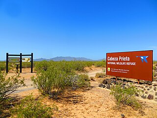
Cabeza Prieta National Wildlife Refuge (CPNWR) is located in southwestern Arizona in the United States, along 56 miles (90 km) of the Mexico–United States border. It is bordered to the north and to the west by the Barry M. Goldwater Air Force Range, to the south by Mexico's El Pinacate y Gran Desierto de Altar Biosphere Reserve, to the northeast by the town of Ajo, and to the southeast by Organ Pipe Cactus National Monument.

The Gila National Forest is a protected national forest in New Mexico in the southwestern part of the United States established in 1905. It covers approximately 2,710,659 acres (10,969.65 km2) of public land, making it the sixth largest National Forest in the continental United States. The Forest also manages that part of the Apache National Forest that is in New Mexico which totals an additional 614,202 acres for a total of 3.3 million acres managed by the Gila National Forest. Part of the forest, the Gila Wilderness, was established in 1924 as the first designated wilderness reservation by the U.S. federal government. Aldo Leopold Wilderness and the Blue Range Wilderness are also found within its borders.

The Mogollon Mountains or Mogollon Range are a mountain range in Grant County and Catron County of southwestern New Mexico, in the Southwestern United States. They are primarily protected within the Gila National Forest.
Luna Lake is a natural body of water that covers approximately 75 acres (0.30 km2) of land. It is located about three miles (5 km) southeast of Alpine, Arizona, at the elevation of 7,890 ft (2,400 m), and is the centerpiece of the Luna Lake Wildlife Area.

The following is an alphabetical list of articles related to the U.S. state of Arizona.

The roundtail chub is a cyprinid fish in the genus Gila, of southwestern North America. It is native to the Colorado River drainage basin, including the Gila River and other tributaries, and in several other rivers. It is part of the “robusta complex”, which includes the Gila robusta robusta, G.r. grahami, and G.r. seminuda.
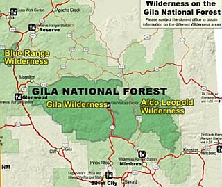
Gila Wilderness was designated the world's first wilderness area on June 3, 1924. Along with Aldo Leopold Wilderness and Blue Range Wilderness, the 558,014 acres (225,820 ha) wilderness is part of New Mexico's Gila National Forest. The wilderness is approximately 27 miles (43 km) from north to south and 39 miles (63 km) east to west. U.S. Wilderness Areas do not allow motorized or mechanized vehicles, including bicycles. Camping, hunting, and fishing are allowed with proper permit, but no roads, buildings, logging, or mining are permitted. Wilderness areas within National Forests and Bureau of Land Management areas allow hunting in season.

The bonytail chub or bonytail is a cyprinid freshwater fish native to the Colorado River basin of Arizona, California, Colorado, Nevada, New Mexico, Utah and Wyoming in the southwestern United States; it has been extirpated from the part of the basin in Mexico. It was once abundant and widespread in the basin, its numbers and range have declined to the point where it has been listed as endangered since 1980 (ESA) and 1986 (IUCN), a fate shared by the other large Colorado basin endemic fish species like the Colorado pikeminnow, humpback chub, and razorback sucker. It is now the rarest of the endemic big-river fishes of the Colorado River. There are 20 species in the genus Gila, seven of which are found in Arizona.
The Pecos Wilderness is a protected wilderness area within the Santa Fe National Forest and Carson National Forest. The Pecos Wilderness lies within the Camino Real Ranger District of the Carson National Forest, and the Pecos Ranger District and Espanola Ranger District of the Santa Fe National Forest. The Pecos Wilderness includes the southernmost extension of the Rocky Mountains in the sub-range of the Sangre de Cristo Mountains of north central New Mexico. One trail head for the wilderness is only 15 miles by road from Santa Fe, the state capital. Covering an area of 223,667 acres (90,515 ha)(350 sq mi) it is the second largest wilderness in the state after the Gila Wilderness. An area of less than 200,000 acres (81,000 ha) was given wilderness protection by Congress in 1964. Congress protected an additional 55,000 acres (22,000 ha) in 1980. The Wilderness boasts one of the highest concentrations of peaks exceeding 12,000 feet (3,700 m) in elevation in New Mexico, including Santa Fe Baldy, 12,622 feet (3,847 m), the highest point in Santa Fe County, and South Truchas Peak, 13,102 feet (3,993 m), the second highest peak in the state.
The Guzmán Basin is an endorheic basin of northern Mexico and the southwestern United States. It occupies the northwestern portion of Chihuahua in Mexico, and extends into southwestern New Mexico in the United States.

The Tinajas Altas Mountains are an extremely arid northwest-southeast trending mountain range in southern Yuma County, Arizona, approximately 35 mi southeast of Yuma, Arizona. The southern end of the range extends approximately one mile into the northwestern Mexican state of Sonora on the northern perimeter of the Gran Desierto de Altar. The range is about 22 mi in length and about 4 mi wide at its widest point. The highpoint of the range is unnamed and is 2,766 feet above sea level and is located at 32°16'26"N, 114°02'48"W. Aside from the portion of the range in Mexico, the entirety of the range lies within the Barry M. Goldwater Air Force Range. They lie at the heart of the traditional homeland of the Hia C-eḍ O'odham people.

The Gila Mountains of Yuma County are a 26-mile (42 km) long mountain range in southwestern Arizona in the northwest Sonoran Desert.

The Black River is a 114-mile-long (183 km) river in the White Mountains of the U.S. state of Arizona. It forms southwest of Alpine and flows southwest then northwest to meet the White River west of Fort Apache. The merged streams form the Salt River, a major tributary of the Gila River.
The Imperial National Wildlife Refuge protects wildlife habitat along 30 miles (50 km) of the lower Colorado River in Arizona and California, including the last un-channeled section before the river enters Mexico. The Imperial Refuge Wilderness, a federally designated, 15,056-acre (60.93 km2), wilderness area is protected within the refuge. It also surrounds the Picacho State Recreation Area. This section of the Colorado River is popular for boating, hiking, fishing, camping, exploring old mining camps and wildlife watching.

The Arizona Mountains forests are a temperate coniferous forests ecoregion of the southwest United States with a rich variety of woodland habitats and wildlife.