Related Research Articles

Charles Yelverton O'Connor,, was an Irish engineer who is best known for his work in Western Australia, especially the construction of Fremantle Harbour, thought to be impossible, and the Goldfields Water Supply Scheme.

Northam is a town in the Australian state of Western Australia, situated at the confluence of the Avon and Mortlock Rivers, about 97 kilometres (60 mi) east-northeast of Perth in the Avon Valley. At the 2016 census, Northam had a population of 6,548. Northam is the largest town in the Avon region. It is also the largest inland town in the state not founded on mining.
The Waranga Dam is a major earthfill embankment dam with an uncontrolled spillway located approximately 150 kilometres (93 mi) north of Melbourne in the North Central region of the Australian state of Victoria. The impounded off-stream reservoir is Waranga Basin and forms part of the Goulburn River irrigation system, irrigating an area of 626 square kilometres (242 sq mi). The dam and reservoir are located in Shire of Campaspe near the City of Greater Shepparton and is located 8 kilometres (5.0 mi) northeast of Rushworth, 12 kilometres (7.5 mi) southwest of Tatura, and near Murchison. When full, the reservoir covers an area of 58.5 square kilometres (22.6 sq mi).

Leonora is a town in the Goldfields-Esperance region of Western Australia, located 833 kilometres (518 mi) northeast of the state capital, Perth, and 237 kilometres (147 mi) north of the city of Kalgoorlie.

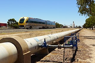
Merredin is a town in Western Australia, located in the central Wheatbelt roughly midway between Perth and Kalgoorlie, on Route 94, Great Eastern Highway. It is located on the route of the Goldfields Water Supply Scheme, and as a result is also on the Golden Pipeline Heritage Trail.

Cunderdin is a town located in the Wheatbelt region of Western Australia 156 km east of Perth, along the Great Eastern Highway. Due to it being on the route of the Goldfields Water Supply Scheme it is also on the Golden Pipeline Heritage Trail. It is a rural community consisting of a district high school and an agricultural college.
Bullabulling is a small townsite located 526 km (327 mi) east of Perth, Western Australia on the Great Eastern Highway in the Goldfields-Esperance region.
The Eastern Goldfields Railway was built in the 1890s by the Western Australian Government Railways to connect Perth with the Eastern Goldfields at Coolgardie and Kalgoorlie.
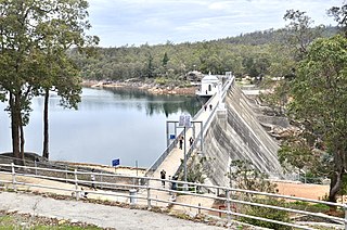
Mundaring Weir is a dam located 39 kilometres (24 mi) from Perth, Western Australia in the Darling Scarp. The dam and reservoir form the boundary between the suburbs of Reservoir and Sawyers Valley. The dam impounds the Helena River.

The Goldfields Water Supply Scheme is a pipeline and dam project that delivers potable water from Mundaring Weir in Perth to communities in Western Australia's Eastern Goldfields, particularly Coolgardie and Kalgoorlie. The project was commissioned in 1896 and completed in 1903.

The Prospect Reservoir is a heritage-listed 50,200-megalitre potable water supply and storage reservoir created by the Prospect Dam, across the Prospect Creek located in the Western Sydney suburb of Prospect, in New South Wales, Australia. The eastern bounds of the reservoir are a recreational area and the western periphery are within the bounds of Western Sydney Parklands. It was added to the New South Wales State Heritage Register on 18 November 1999.
Agnew is a ghost town in the Goldfields-Esperance region of Western Australia 982 kilometres (610 mi) north-east of Perth; the closest populated town is Leinster.

Burtville is an abandoned town in the Goldfields-Esperance region of Western Australia, located 29 kilometres (18 mi) south east of Laverton.
Bulong is an abandoned town in Western Australia located 580 kilometres (360 mi) east of Perth in the Goldfields-Esperance region of Western Australia.
Comet Vale is an abandoned town in Western Australia located in the Goldfield region of Western Australia located between Kalgoorlie and Laverton on the Goldfields Highway. It is within the Shire of Menzies.

Golden Pipeline Heritage Trail was a project conducted by the National Trust of Western Australia along the Goldfields Water Supply Scheme pipeline at the time the pipeline was being celebrated for its 100 years of operation.

The Morgan – Whyalla pipeline was an engineering project undertaken by the South Australian Government in 1940 to bring water from Morgan on the River Murray to the industrial city of Whyalla. A second pipeline, by a divergent route, was laid in the 1960s.
Yerbillon, Western Australia was the location of Number 5 Pumping station on the Goldfields Water Supply Scheme, and is the location of the current pumping station number 11 on the pipeline. It was also located on the Eastern Goldfields Railway.

Ghouli, Western Australia was the location of Number 6 Pumping station on the Goldfields Water Supply Scheme, and is the location of the current pumping station number 14 on the pipeline.
Dedari, Western Australia was the location of Number 8 Pumping station on the Goldfields Water Supply Scheme
References
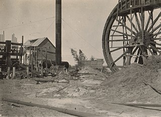
- ↑ No.7 Pumping Station, Gilgai, 1900, retrieved 12 October 2016
- ↑ Walker, Marshal (2003). The Pump. Hesperian Press. ISBN 978-0-85905-323-5.
- ↑ Miller, N.D. (1962), No. 7 Pumping Station, Goldfields Water Supply , retrieved 12 October 2016
- ↑ Gilmour, Hugh; Hartley, Richard G; Goldfields and Agricultural Water Supply History Project; Water Corporation of Western Australia (2002), [Interview with Hugh Gilmour] , retrieved 12 October 2016