
The Sierra Nevada is a mountain range in the Western United States, between the Central Valley of California and the Great Basin. The vast majority of the range lies in the state of California, although the Carson Range spur lies primarily in Nevada. The Sierra Nevada is part of the American Cordillera, an almost continuous chain of mountain ranges that forms the western "backbone" of the Americas.

The Desolation Wilderness is a 63,960-acre (258.8 km2) federally protected wilderness area in the Eldorado National Forest and Lake Tahoe Basin Management Unit, in El Dorado County, California. The crest of the Sierra Nevada runs through it, just west of Lake Tahoe.

The Tahoe Rim Trail is a 170-mile (274 km) long-distance hiking trail that forms a loop around the Lake Tahoe Basin in the Sierra Nevada and ranges of Nevada and California in the United States. The trail ranges in elevation from 6,223 feet at the outlet of Lake Tahoe to 10,338 feet at Relay Peak in Nevada. About 50 miles (80 km) of trail above the lake's west shore are also part of the national Pacific Crest Trail. Additionally, 96 Miles of the trail along the east and south sides of the Lake Tahoe basin are designated as a National Recreation Trail.

The Granite Chief Wilderness is a 19,048 acre (77 km2) federally designated wilderness area of the Tahoe National Forest. Created by the California Wilderness Act of 1984, it is located in the Sierra Nevada mountains west of Lake Tahoe in the U.S. state of California. It is managed by the U.S. Forest Service Tahoe National Forest. Elevations range from 4,800 feet (1,500 m) to 9,019 feet (2,749 m) at the summit of Granite Chief.

Tahoe National Forest is a United States National Forest located in California, northwest of Lake Tahoe. It includes the 8,587-foot (2,617 m) peak of Sierra Buttes, near Sierra City, which has views of Mount Lassen and Mount Shasta. It is located in parts of six counties: Sierra, Placer, Nevada, Yuba, Plumas and El Dorado. The forest has a total area of 871,495 acres. Its headquarters is in Nevada City, California. There are local ranger district offices in Camptonville, Foresthill, Sierraville and Truckee.
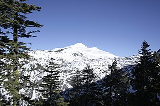
Pyramid Peak is a mountain in the California's Sierra Nevada in the Crystal Range to the west of Lake Tahoe. It is the highest point in the Desolation Wilderness. With an elevation gain of almost 4,100 feet (1,250 m), the Rocky Canyon route is the mountain's most popular approach although it is very arduous. To the east, at the base of the peak, lies Pyramid Lake.

Fallen Leaf Lake is a mountain lake located in El Dorado County, California, near the California–Nevada state border, about one mile south west of the much larger Lake Tahoe. It is approximately aligned north-to-south and oval in shape, measuring approximately 2.9 miles (4.6 km) on the long axis and 0.9 miles (1.4 km) on the short axis. The lake was created by at least two glaciers that traveled northward down the Glen Alpine Valley. If the glacier had continued instead of stopping, Fallen Leaf Lake would be a bay of Lake Tahoe, similar to nearby Emerald Bay. A terminal moraine is visible at the north end of the lake on the northeast edge.
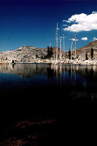
Lake Aloha is a large shallow backcountry reservoir located at an elevation of 8,116 feet in the Sierra Nevada Range, west of Lake Tahoe in El Dorado County, in eastern California.
Wrights Lake is in the Sierra Nevada mountain range, west of Lake Tahoe on the western border of the Desolation Wilderness. It can be reached via Wrights Road off U.S. Route 50 and the Ice House Road. It provides hiking access to the western portions of the Desolation Wilderness via the Twin Lakes trailhead. Wrights Road is not plowed and is inaccessible during the winter.
Red Peak is a mountain in the Sierra Nevada mountain range at the north end of the Crystal Range, to the west of Lake Tahoe. It is located in the Desolation Wilderness in El Dorado County, California.

Ralston Peak is a mountain in the Sierra Nevada mountain range to the west of Lake Tahoe within the Desolation Wilderness in El Dorado County, California. Ralston Peak is a very popular mountain to summit for the views of the wilderness area as it lies very near U.S. Route 50. The closest trailhead to the summit can be found in Camp Sacramento a few miles west of Echo Summit. Ralston Peak can also be accessed from the Pacific Crest Trail between Echo Lake and Lake Aloha. Starting at the nearest trailhead, this route is significantly longer than the trail from Camp Sacramento. But the altitude gain on this route is much less, and the trail is much less steep.
Middle Mountain is a mountain in the Sierra Nevada mountain range to the west of Lake Tahoe in the Desolation Wilderness in El Dorado County, California. The mountain is east of the Crystal Range and Rockbound Valley, and west of Emerald Bay and Lake Tahoe.
Rubicon Peak is a mountain in the Sierra Nevada mountain range to the west of Lake Tahoe in the Desolation Wilderness in El Dorado County, California.

Mount Tallac is a mountain peak southwest of Lake Tahoe, in El Dorado County, California. The peak lies within the Desolation Wilderness in the Eldorado National Forest. It is quite visible from State Routes 89 and 28, and U.S. Route 50. A "cross of snow" is clearly visible on the mountain's face during the winter, spring, and early summer months.

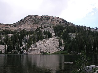
Eagle Lake is a backcountry lake in the Sierra Nevada mountain range, to the west of Lake Tahoe in the Desolation Wilderness. It can be reached by hiking west out of the Eagle Lake trailhead on HWY 89 at Emerald Bay State Park.

The California Alpine Club (CAC) is an all-volunteer, outdoors-oriented social group centered in the San Francisco Bay and Sacramento areas that organizes hiking, skiing, member dinners, and wilderness trips. Club members also manage the California Alpine Club Foundation, which gives grants to California-based wilderness preservation, conservation, outdoor recreation, and education projects.
Ed Z'berg Sugar Pine Point State Park is a state park in California in the United States. It occupies nearly two miles of the western shore of Lake Tahoe and a total of about 1,000 hectares of forested mountains in El Dorado County. Originally called Sugar Pine Point State Park, its name was changed in 2003 to honor Edwin L. Z'berg, a California state assemblyman who specialized in environmental legislation and worked to develop state parks and other natural areas.
The protected areas of the Sierra Nevada, a major mountain range located in the U.S. states of California and Nevada, are numerous and highly diverse. Like the mountain range itself, these areas span hundreds of miles along the length of the range, and over 14,000 feet of elevation from the lowest foothills to the summit of Mount Whitney.

Dicks Peak is a 9,974-foot-elevation (3,040 meter) mountain summit located in the Sierra Nevada mountain range in El Dorado County, California, United States. It is the third-highest peak in the Desolation Wilderness, and is set on land managed by Eldorado National Forest. It is situated six miles (10 km) south of Lake Tahoe, and approximately eight miles (13 km) west of the community of South Lake Tahoe. Topographic relief is significant as the west aspect rises over 2,300 feet (700 meters) above Rockbound Valley in approximately one mile. One-half mile east of the peak the Pacific Crest Trail and Tahoe Rim Trail traverse Dicks Pass, which provides an approach option for those climbing the peak. Inclusion on the Sierra Peaks Section peakbagging list generates climbing interest.

Jakes Peak is a 9,187-foot-elevation (2,800 meter) mountain summit located in the Sierra Nevada mountain range in El Dorado County, California, United States. It is set within the Desolation Wilderness, on land managed by Eldorado National Forest. This iconic peak is situated above the southwest shore of Lake Tahoe, and approximately seven miles (11 km) northwest of the community of South Lake Tahoe. Topographic relief is significant as the east aspect rises 2,950 feet (900 meters) above the lake in 1.5 mile (2.4 km).


