Gimnyeonggul

Last updated
Gimnyeonggul
Hangul 김녕굴
Hanja
Revised Romanization Gimnyeonggul
McCune–Reischauer Kimyŏnggul

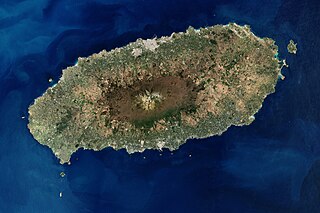
The Gimnyeonggul Lava Tube , located in Donggimnyeong-ri, Gujwa-eup, Jeju City, is one of the World Heritage Sites in South Korea.

Lava tube Natural conduit through which lava flows beneath the solid surface

A lava tube is a natural conduit formed by flowing lava which moves beneath the hardened surface of a lava flow. Tubes can drain lava from a volcano during an eruption, or can be extinct, meaning the lava flow has ceased, and the rock has cooled and left a long cave.

Jeju City Administrative city in Jeju, South Korea

Jeju is the capital of Jeju Province in South Korea and the largest city on Jeju Island. The city is served by Jeju International Airport.

Contents

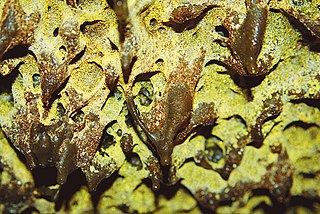
The lava tube is about 705 m long, and is believed to be separated from Manjanggul Lava Tube by lava flows. The upper part of entrance is 12 m high and 4 m wide and is bent in a collapsed S shape. The upstream end of the passage was sealed with subsequent lava flows. The downstream passage is bi-level and the entrance is filled with sediments, most of which are carbonate sediments that had flown in from the beach. This is understood to be why there are lime features.

Manjanggul

The Manjanggul Lava Tube is located in Gimnyeong-ri, Gujwaeup, Jeju City. At up to 23m wide, 30m high and 8.928km long, it is the 12th-longest lava tube in the world and the second longest on Jeju island. It is regarded as having significant scientific and heritage value, owing to its excellent condition of preservation despite its age of formation.

Carbonate salt or ester of carbonic acid

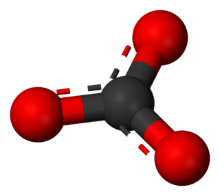
In chemistry, a carbonate is a salt of carbonic acid (H2CO3), characterized by the presence of the carbonate ion, a polyatomic ion with the formula of CO2−
3
. The name may also refer to a carbonate ester, an organic compound containing the carbonate group C(=O)(O–)2.

The upstream end part is covered by a rich natural forest and the other end is covered with sand dunes. There is a significant amount of sand inside the tube. Because very little organic material has infiltrated the tube, Gimnyeonggul does not offer favorable habitats for cave life. Around 20 species are living in tube.

Dune A hill of loose sand built by aeolian processes or the flow of water

In physical geography, a dune is a hill of loose sand built by aeolian processes (wind) or the flow of water. Dunes occur in different shapes and sizes, formed by interaction with the flow of air or water. Most kinds of dunes are longer on the stoss (upflow) side, where the sand is pushed up the dune, and have a shorter "slip face" in the lee side. The valley or trough between dunes is called a slack. A "dune field" or erg is an area covered by extensive dunes.

The Gimnyeong lava tube is also called "Gimnyeongsagul" or "Sagul (Snake Cave)", a name originating in ancient history. According to a legend, there was a big snake living in the cave, and the snakes demanded the yearly sacrifice of a girl. If people didn’t make that offering to it, it caused natural disasters such as typhoons. A judge Mr. Lin Seo killed the snake in 1515. After that event, the legend states, the village was able to be in peace. By the entrance of the cave, a monument was established speaking highly of Mr. Lin Seo.

Typhoon type of tropical cyclone

A typhoon is a mature tropical cyclone that develops between 180° and 100°E in the Northern Hemisphere. This region is referred to as the Northwestern Pacific Basin, and is the most active tropical cyclone basin on Earth, accounting for almost one-third of the world's annual tropical cyclones. For organizational purposes, the northern Pacific Ocean is divided into three regions: the eastern, central, and western. The Regional Specialized Meteorological Center (RSMC) for tropical cyclone forecasts is in Japan, with other tropical cyclone warning centers for the northwest Pacific in Hawaii, the Philippines and Hong Kong. While the RSMC names each system, the main name list itself is coordinated among 18 countries that have territories threatened by typhoons each year A hurricane is a storm that occurs in the Atlantic Ocean or the northeastern Pacific Ocean, a typhoon occurs in the northwestern Pacific Ocean, and a tropical cyclone occurs in the South Pacific or the Indian Ocean.

See also

Jeju Volcanic Island and Lava Tubes island

The Jeju Volcanic Island and Lava Tubes is a World Heritage Site in South Korea.

Seongsan Ilchulbong mountain

Seongsan Ilchulbong, also called ‘Sunrise Peak’, is an archetypal tuff cone formed by hydrovolcanic eruptions upon a shallow seabed about 5 thousand years ago. Situated on the eastern seaboard of Jeju Island and said to resemble a gigantic ancient castle, this tuff cone is 182 meters high, has a preserved bowl-like crater and also displays diverse inner structures resulting from the sea cliff. These features are considered to be of geologic worth, providing information on eruptive and depositional processes of hydromagmatic volcanoes worldwide as well as past volcanic activity of Seongsan Ilchulbong itself.

Hallasan Mountain

Hallasan is a shield volcano on Jeju Island of South Korea. It is the highest mountain in South Korea. The area around the mountain is a designated national park, the Hallasan National Park. Hallasan is commonly considered to be one of the three main mountains of South Korea, along with Jirisan and Seoraksan.

Related Research Articles

Lava Beds National Monument national monument in the United States

Lava Beds National Monument is located in northeastern California, in Siskiyou and Modoc counties. The monument lies on the northeastern flank of Medicine Lake Volcano and has the largest total area covered by a volcano in the Cascade Range.

Jeju Province Special Self-Governing Province in Jeju, South Korea

Jeju Province, officially Jeju Special Self-Governing Province, is one of the nine provinces of South Korea. The province is situated on the nation's largest island of Jeju, formerly transliterated as Cheju, Cheju Do, etc. It was previously known as Quelpart to Europeans and during the Japanese occupation as Saishū. The island lies in the Korea Strait, southwest of South Jeolla Province, of which it was a part before it became a separate province in 1946. Its capital is Jeju City.

Seogwipo Administrative city in Jeju, South Korea

Seogwipo is the second-largest city on Jeju Island, settled on a rocky volcanic coastline in the southern part of Jeju Province, South Korea. In July 2006, Seogwipo's boundaries were expanded to include the entire southern half of Jeju island. A UNESCO World Heritage site and 2002 FIFA World Cup host, it had a population of 155,691 as of December 31, 2011.

Jeju Island South Korean island

Jeju Island is an island in Jeju Province, South Korea. The island lies in the Korea Strait, south of South Jeolla Province. The island contains the natural World Heritage Site Jeju Volcanic Island and Lava Tubes. Jejudo has a moderate climate; even in winter, the temperature rarely falls below 0 °C (32 °F). Jeju is a popular holiday destination and a sizable portion of the economy relies on tourism and economic activity from its civil/naval base.

Cheonjeyeon Waterfalls Waterfall

Cheonjeyeon Waterfall is a three-tier waterfall located on Jeju Island. Cold water flows out of the ceiling of a cave to make the waterfall. Between the precipice of the waterfall and the lower clay layer, water springs out. In first cascade, the cliff is 22 m (72 ft) high and the water falls into Cheonjeyeon pond which is 21 m (69 ft) deep. From there, the water goes to the second waterfall and falls 30 m (98 ft) and continues to the third waterfall. Eventually, the water reaches the ocean. Cheonjeyeon means Pond of the Emperor of Heaven. According to Korean legend, seven nymphs would descend from the heavens at night and bathe in the waterfall's pond. The falls are a popular tourist attraction on Jeju-do.

Volcanic dam A natural dam produced directly or indirectly by volcanism

A volcanic dam is a type of natural dam produced directly or indirectly by volcanism, which holds or temporarily restricts the flow of surface water in existing streams, like a man-made dam. There are two main types of volcanic dams, those created by the flow of molten lava, and those created by the primary or secondary deposition of pyroclastic material and debris. This classification generally excludes other, often larger and longer lived dam-type geologic features, separately termed crater lakes, although these volcanic centers may be associated with the source of material for volcanic dams, and the lowest portion of its confining rim may be considered as such a dam, especially if the lake level within the crater is relatively high.

Lava cave Cave formed in volcanic rock, especially one formed via volcanic processes

A lava cave is any cave formed in volcanic rock, though it typically means caves formed by volcanic processes, which are more properly termed volcanic caves. Sea caves, and other sorts of erosional and crevice caves, may be formed in volcanic rocks, but through non-volcanic processes and usually long after the volcanic rock was emplaced.

Lava River Cave

The Lava River Cave near Bend, Oregon, is part of the Newberry National Volcanic Monument, which is managed by the United States Forest Service. At 5,211 feet (1,588 m) in length, the northwest section of the cave is the longest continuous lava tube in Oregon. While the cave’s discovery in 1889 was officially credited to a pioneer hunter, the presence of obsidian flakes near the cave has led archaeologists to conclude that Native Americans knew about the cave long before settlers arrived in central Oregon.

Hallasan National Park national park in Jeju-do, South Korea

Hallasan National Park is located in the province of Jeju-do, South Korea. It was designated as the 9th national park in 1970. It features the highest mountain in South Korea, the shield volcano Hallasan on Jeju Island. It was designated a UNESCO Biosphere Reserve in 2002, and a World Heritage Site in 2007.

Cueva del Viento is the largest lava tube system in Europe, and the fifth largest in the world, behind a series of lava tubes in Hawaii. It is also considered the most complex volcanic tube in the world, due to its morphology of several levels and passages.

Gruta das Torres cave in Portugal

The Gruta das Torres, is a lava cave, a geological formation of volcanic origin formed from the flow and cooling of subterranean magma rivers. This formation is located outside the parish of Criação Velha, in the municipality of Madalena, on the western flanks of the island of Pico. The cave system formed from a series of pāhoehoe lava flows which originating from the Cabeço Bravo parasitic cone about 500 to 1500 years ago. The caves are a group of interconnected lava tubes between 0.5–22 metres (2–72 ft) width, created from both pāhoehoe and ʻaʻā types of lavas generated during different geological periods. It has a height between 1.1 and 15 metres (3.6–49 ft) and is located at an elevation of 300 metres (980 ft). With an estimated length of over 5.2 km (3.2 mi) it is the longest lava cave in the Azores. Access to the cave was managed by the Mountaineering Association. Starting in 2011, AZORINA, SA took over the management and organization of the cave.

The Geomunoreum Lava Tube System is located between Seonheul-ri, Jocheon-eup and Weoljeong-ri, Gujwa-eup, Jeju City, Jeju-do. This lava tube system refers to a series of lava tubes formed while basaltic lava flow which had erupted several times from the Geomunoreum volcano flowed in a north-northeast direction, down to the coastline for about 13㎞. It is estimated that it was formed between about 100 and 300 thousand years ago.

Jeju Oreum is the rising small defunct volcano in the Jeju Island in South Korea. The word "oreum" is the Jeju dialect which implies the parasitic cone [Hangul: 측화산, Hanja: 側火山) and the origin of a word "oreum" is a noun type of the word "climb". The name refers to a small volcano within a main volcanic crater in Jeju-do and is usually applied to the hill in Jeju. The cinder cone, symbolizing the oreum, is a typical form of Jeju Oreum. The Oreum is divided into pyroclastic cone, tuff cone and lava dome depending on the nature of volcanic eruptions. The pyroclastic cones are volcanic bodies formed by the accumulation of volcanic clusters released into the air by explosive eruption.

References