Jeju Volcanic Island and Lava Tubes

Last updated
Jeju Volcanic Island and Lava Tubes
UNESCO World Heritage Site
KOCIS Yongcheon Cave in Jeju-do (6387785715).jpg
The Millennium Lake in Yongcheon Cave (2009)
Location Jeju Island, South Korea
Includes
Reference 1264
Inscription2007 (31st Session)
Area9,475.2 ha (23,414 acres)
Buffer zone9,370.8 ha (23,156 acres)
Coordinates 33°28′8″N126°43′13″E / 33.46889°N 126.72028°E / 33.46889; 126.72028
Korean name
Hangul
제주도 자연유산지구
Hanja
Revised Romanization Jejudo jayeonyusanjigu
McCune–Reischauer Chejudo chayŏnyusanjigu
South Korea physical map2.svg
Red pog.svg
Location of Jeju Volcanic Island and Lava Tubes in South Korea

The Jeju Volcanic Island and Lava Tubes is a World Heritage Site in South Korea. [1] It was inscribed as one of the UNESCO World Heritage Sites in 2007 because of the Geomunoreum Lava Tube System and the exhibition of diverse and accessible volcanic features which are considered to demonstrate a distinctive and valuable contribution to the understanding of global volcanism. [2]

Contents

Jeju, also known as Jejudo, is a volcanic island, 130 kilometers from the southern coast of the Korean Peninsula. The largest island and smallest province in South Korea, the island has a surface area of 1,846 square kilometers. [3]

Formations

A central feature of Jeju is Hallasan, the tallest mountain in South Korea and a dormant volcano, which rises 1,950 meters above sea level. The main volcano includes 360 satellite volcanoes. Volcanic activity on Jeju began approximately in the Cretaceous and lasted until the early Tertiary period. The most recent eruptions are estimated to be about 5,000 years ago, which puts the volcano into the active classification, meaning eruptions in the last 10,000 years. [4] [5] The designation as active is not agreed by all, as more monitoring and study are needed to better understand the volcano. [5] The island is covered in volcanic rock and volcanic soil produced by Hallasan (Hangul: 한라산). Baengnokdam (Hangul: 백록담), the crater, and lake in it are located at the peak of Hallasan, which was formed over 25,000 years ago.

Jeju is scientifically valuable for its extensive system of lava tubes (also known as lateral volcanoes or in Korean as Oreum ). These natural conduits through which magma once flowed are now empty caves that are some of the largest in the world. The caves provide opportunities for scientific research and are also popular tourist destinations.

Off the shores of the city of Seogwipo are a vast belt of pillar-shaped rocks that are examples of the natural beauty of Jeju. Shellfish and animal fossils discovered in this area are also very valuable as scientific resources. Beom Island (Beomseom 범섬, sometimes still misspelled Pomsom) and Mun Island (Munseom 문섬, sometimes spelled Munsom), also off the city seacoast, are also well preserved and scenic areas.

The variety of animal and plant species on Jeju is also an important reason for its value as a natural reserve. Half of all Korean vascular plants grow naturally on the island while another 200 species of plants indigenous to Korea have been transported here. However, half of these species face extinction. The polar plants which came from the south during a glacial period and inhabit the peak of Jeju is one example. Other plants in the subtropical forest and lower regions of the island are also endangered.

Mt. Halla National Park

Hallasan is located in the central part of the island. Since 1966, any area 800 meters above sea level has been designated as a nature reserve. The park is mostly unspoilt nature with hiking paths and park managerial facilities being the only man-made modifications in the area.

The flora at the Mt. Halla National Park is unique. 1,565 vascular plant species have been recorded in the area thus far and is the highest number of plants in any mountain, 33 which are endemic to the island. Unlike most other Korean mountain environments, Hallsan has a unique vertical distribution of plants in three different zones: the subtropic, temperate, and frigid zones.

Over 17 mammals, 198 types of birds, 8 types of amphibians, 8 types of reptiles, and 947 insect species have been catalogued in the nature reserve. Endangered species include the Capreolus capreolus pygargus and Felis bengalensis manchuria , and a resident population of Indo-Pacific bottlenose dolphins and finless porpoises. [6] Historically, the island and adjacent waters had been migration colliders and resting areas for large whales such as western gray whales, North Pacific right whales, [7] humpback whales, blue whales and fin whales. [8] Now possibly extinct Japanese sea lions might have colonized on the island as well. Some pinnipeds still occur occasionally. Since the island was last connected to the Korean Peninsula 10,000 years ago, animals endemic to the island appeared at that time and this separation from the mainland is also of biological significance.

A famous part of the Mt. Halla Nature Reserve is the Pillemot Cave, a site dating to the Paleolithic period. The caves are significant because of the archaeological remains found there. Archaeological evidence from the cave suggests that people have occupied the island since the Paleolithic period.

See also

Related Research Articles

<span class="mw-page-title-main">Mount Pelée</span> Active volcano on the Caribbean island of Martinique

Mount Pelée or Mont Pelée is an active volcano at the northern end of Martinique, an island and French overseas department in the Lesser Antilles Volcanic Arc of the Caribbean. Its volcanic cone is composed of stratified layers of hardened ash and solidified lava. Its most recent eruption was in 1932.

<span class="mw-page-title-main">Jeju Province</span> Special Self-Governing Province of South Korea

Jeju Province, officially Jeju Special Self-Governing Province, is the southernmost province of South Korea, consisting of 8 inhabited and 55 uninhabited islands, including Mara Island, U Island, the Chuja Archipelago, and the country's largest island Jeju Island. The province is located in the Korea Strait, with the Korean Peninsula to the northwest, Japan to the east, and China to the west. The province has two cities: the capital Jeju City, located on the northern half of the island and Seogwipo, located on the southern half of the island. The island is home to the shield volcano Hallasan, the highest point in South Korea. Jeju and Korean are the official languages of the province, and the vast majority of residents are bilingual.

<span class="mw-page-title-main">Hallasan</span> Volcano on Jeju Island, South Korea

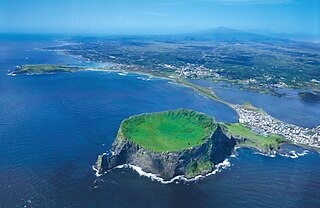
Hallasan (Korean: 한라산) is a shield volcano on Jeju Island in South Korea. Its summit, at 1,947 m (6,388 ft), is the highest point in the country. The area around the mountain is a designated national park, named Hallasan National Park. Hallasan is commonly considered to be one of the three main mountains of South Korea, along with Jirisan and Seoraksan.

<span class="mw-page-title-main">Lava tube</span> Natural conduit through which lava flows beneath the solid surface

A lava tube, or pyroduct, is a natural conduit formed by flowing lava from a volcanic vent that moves beneath the hardened surface of a lava flow. If lava in the tube empties, it will leave a cave.

<span class="mw-page-title-main">Kamchatka Peninsula</span> Peninsula in the Russian Far East

The KamchatkaPeninsula is a 1,250-kilometre-long (777 mi) peninsula in the Russian Far East, with an area of about 270,000 km2 (100,000 sq mi). The Pacific Ocean and the Sea of Okhotsk make up the peninsula's eastern and western coastlines, respectively. Immediately offshore along the Pacific coast of the peninsula runs the 10,500-metre-deep (34,449 ft) Kuril–Kamchatka Trench.

<span class="mw-page-title-main">Seogwipo</span> Administrative city in Jeju, South Korea

Seogwipo is the second-largest city on Jeju Island, settled on a rocky volcanic coastline in the southern part of Jeju Province, South Korea. In July 2006, Seogwipo's boundaries were expanded to include the entire southern half of Jeju island. A UNESCO World Heritage Site and 2002 FIFA World Cup host, it had a population of 155,691 as of December 31, 2011.

<span class="mw-page-title-main">Parasitic cone</span> Geological feature associated with some volcanos

A parasitic cone is the cone-shaped accumulation of volcanic material not part of the central vent of a volcano. It forms from eruptions from fractures on the flank of the volcano. These fractures occur because the flank of the volcano is unstable. Eventually, the fractures reach the magma chamber and generate eruptions called flank eruptions, which, in turn, produce a parasitic cone.

<span class="mw-page-title-main">Jeju Island</span> Island of South Korea

Jeju Island is South Korea's largest island, covering an area of 1,833.2 km2 (707.8 sq mi), which is 1.83 percent of the total area of the country. Alongside outlying islands, it is part of Jeju Province.

<span class="mw-page-title-main">Geography of Korea</span>

Korea comprises the Korean Peninsula and 3,960 nearby islands. The peninsula is located in Northeast Asia, between China and Japan. To the northwest, the Amnok River separates Korea from China and to the northeast, the Duman River separates Korea from China and Russia. The Yellow Sea lies to the west, the East China Sea and Korea Strait to the south, and the Korean East Sea to the east. Notable islands include Jeju Island (Jejudo), Ulleung Island (Ulleungdo), and the Liancourt Rocks.

<span class="mw-page-title-main">Daepo Jusangjeolli Cliff</span> Rock formation on Jeju, South Korea

Daepo Jusangjeolli Cliff is a volcanic rock formation at the southern coast of Jeju Island, South Korea. It is named for jusangjeolli, the Korean term for columnar jointing.

Mulyeongari-oreum is a lake and wetland located on Jeju island. It is the only wetland in Korea which is located within a volcanic crater in a parasitic cone, called an oreum in the Jeju dialect of Korean. The oreum is one of the secondary volcanoes around the Hallasan volcano, which is the highest mountain in South Korea. Through continuing scientific research, it is thought that Mulyeongari-oreum was formed by volcanic activity continuing for 2,500 years at the end of the third Cenozoic Era on Jeju Island. On top of the oreum, there is a shallow crater lake which displays a unique example of a wetland. The level of water changes with the seasons due to rainfall and the particular geology. Some 370 parasitic cones are located around Hallasan. Only about 30% of them have mountain craters. The geology is mostly composed of water-permeable basalt, so it is unusual to have a lake on top of such volcanic cones. During the dry season, most of wetland becomes dries out, except the deepest part in the south. During the rainy season, most of it is submerged.

<span class="mw-page-title-main">Hallasan National Park</span> National park in Jeju, South Korea

Hallasan National Park is located on and around the mountain Hallasan in Jeju Province, South Korea. It was designated as the 9th national park in 1970.

<span class="mw-page-title-main">Seongsan Ilchulbong</span> Geological landmark

Seongsan Ilchulbong, also called ‘Sunrise Peak’, is an archetypal tuff cone formed by hydrovolcanic eruptions upon a shallow seabed about 5 thousand years ago. Situated on the eastern seaboard of Jeju Island and said to resemble a gigantic ancient castle, this tuff cone is 182 meters high, has a preserved bowl-like crater and also displays diverse inner structures resulting from the sea cliff. These features are considered to be of geologic worth, providing information on eruptive and depositional processes of hydromagmatic volcanoes worldwide as well as past volcanic activity of Seongsan Ilchulbong itself.

<span class="mw-page-title-main">Geomunoreum Lava Tube System</span> Lava tube system on the South-Korean island Jeju

The Geomunoreum Lava Tube System is located between Seonheul-ri, Jocheon-eup and Weoljeong-ri, Gujwa-eup, Jeju City, Jeju-do. This lava tube system refers to a series of lava tubes formed by multiple ancient eruptions of basaltic lava flow from the Geomunoreum volcano The flows followed a north-northeast direction for about 13km, going down to the coastline. It is estimated that the tube system formed between about 100 and 300 thousand years ago.

<span class="mw-page-title-main">Manjanggul</span> Lava tube cave in South Korea

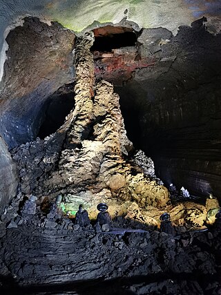
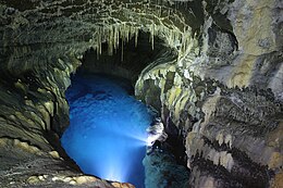
Manjanggul (Korean: 만장굴) is a lava tube located in Gimnyeong-ri, Gujwaeup, Jeju City, South Korea. At up to 23 metres (75') wide, 30 metres (100') high and 8.928 km long, it is the 12th-longest lava tube in the world and the second longest on Jeju Island, although a significant portion of the cave is closed to visitors. It is the only cave of the Geomunoreum Lava Tube System, considered one of the finest lava tube systems in the world, regularly open to the public. It is also part of the UNESCO World Heritage Site list, under the item Jeju Volcanic Island and Lava Tubes.

The Gimnyeonggul Lava Tube, located in Donggimnyeong-ri, Gujwa-eup, Jeju City, is one of the World Heritage Sites in South Korea.

Mt. Songak (Korean: 송악산) is a volcano on Jeju Island which has double craters and a parasitic cone. Crater 1 is about 500 m in diameter, 1.7 km in circumference. Crater 2, the mouth of the volcano in Crater 1, is about 400 m in diameter, 69 m in depth and leans vertically.

Jeju Oreum is a rising small defunct volcano in the Jeju Island in South Korea. The word "oreum" is the Jeju dialect which implies the parasitic cone [Hangul: 측화산, Hanja: 側火山 and the origin of the word "oreum" is a noun type of the word "climb". The name refers to a small volcano within a main volcanic crater in Jeju-do and is usually applied to the hill in Jeju. The cinder cone, symbolizing the oreum, is a typical form of Jeju Oreum. The Oreum is divided into pyroclastic cone, tuff cone and lava dome depending on the nature of volcanic eruptions. The pyroclastic cones are volcanic bodies formed by the accumulation of volcanic clusters released into the air by an explosive eruption.

References

  1. "Natural sites in Madagascar, China and Korea inscribed on UNESCO World Heritage List" . Retrieved 2007-12-26.
  2. "Jeju Volcanic Island and Lava Tubes". UNESCO World Heritage Centre. Retrieved 2021-04-22.
  3. "Geography". Archived from the original on 2006-05-10. Retrieved 2006-07-29. Geography of Jeju
  4. "About Global Volcanism Program". Smithsonian Institution. 2013. Retrieved September 1, 2015.
  5. 1 2 Park, Yea Eun (September 25, 2014). "'There could be volcanic activity, but we don't know': Jeju younger than previously thought, highlights dearth of knowledge about Mt. Hallasan". The Jeju Weekly. Archived from the original on July 17, 2018. Retrieved September 1, 2015.
  6. 황주찬 (2014). "낚시꾼들에겐 찬밥이지만 '귀하신' 몸입니다" . Retrieved 2015-01-11.
  7. "Recovery Strategy for the North Pacific Right Whale in Pacific Canadian Waters". Species at Risk Public Registry. 2011-04-27.
  8. Smith, Tim D.; Reeves, Randall R.; Josephson, Elizabeth A.; Lund, Judith N. (2012). "Spatial and Seasonal Distribution of American Whaling and Whales in the Age of Sail". PLOS ONE. 7 (4): e34905. Bibcode:2012PLoSO...734905S. doi: 10.1371/journal.pone.0034905 . PMC   3338773 . PMID   22558102.