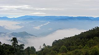
Nuwara Eliya is a city in the hill country of the Central Province, Sri Lanka. Its name means "city on the plain " or "city of light". The city is the administrative capital of Nuwara Eliya District, with a picturesque landscape and temperate climate. It is at an altitude of 1,868 m (6,128 ft) and is considered to be the most important location for tea production in Sri Lanka. The city is overlooked by Pidurutalagala, the tallest mountain in Sri Lanka. Nuwara Eliya is known for its temperate, cool climate – the coolest area in Sri Lanka.

Hatton is a major town in the Nuwara Eliya District of Central Province, Sri Lanka governed by the Hatton-Dickoya Urban Council. Hatton is a major centre of the Sri Lankan tea industry.

Badulla is the capital and the largest city of Uva Province situated in the central hills of Sri Lanka. It is the capital city of Uva Province and the Badulla District.

Nuwara Eliya District is a district in Central Province, Sri Lanka, centered on the tourist city of Nuwara Eliya.

Pidurutalagala, or previously Mount Pedro in English, is the highest mountain in Sri Lanka, at 2,524 m (8,281 ft). It is situated North-North-East from the town of Nuwara Eliya and is easily visible from most areas of the Central Province. Its summit is home to the central communications array of the Government of Sri Lanka and armed forces and serves as an important point in the country's radar system. The peak is currently designated as an "ultra-high security zone", and protected by a large military base; the peak is strictly off-limits to the general public.

Pussellawa Sinhala: පුස්සැල්ලාව. Tamil: புசல்லாவ, is a l town in Kandy District, Sri Lanka. It is located along the A5 road between Gampola and Nuwara Eliya.

Hakgala Botanical Garden is one of the five botanical gardens in Sri Lanka. The other four are Peradeniya Botanical Garden, Henarathgoda Botanical Garden, Mirijjawila Botanical Garden and Seetawaka Botanical Garden. It is the second largest botanical garden in Sri Lanka. The garden is contiguous to Hakgala Strict Nature Reserve.

Savumiamoorthy Arumugam Ramanathan Thondaman was a Sri Lankan politician who served as a Cabinet Minister. He was the grandson of prominent unionist Saumyamoorthi Thondaman. He was the leader of the Ceylon Workers' Congress, a Member of Parliament representing the Nuwara Eliya District and was an advocate for the Indian Tamils of Sri Lanka. His career as a politician spanned over 20 years, holding several ministerial portfolios in different governments. He was regarded as one of the prominent politicians from Nuwara Eliya.

The Central Province is one of the nine provinces of Sri Lanka. The province has an area of 5,674 km2 and a population of 2,421,148, making it the 2nd most populated province. The city of Kandy stands as its capital since 1469.
Nuwara Eliya electoral district is one of the 22 multi-member electoral districts of Sri Lanka created by the 1978 Constitution of Sri Lanka. The district is conterminous with the administrative district of Nuwara Eliya in the Central province. The district currently elects 7 of the 225 members of the Sri Lankan Parliament and had 457,137 registered electors in 2010. The district is Sri Lanka's Electorate Number 06.
The A 7 road is an A-Grade trunk road in Sri Lanka. It connects Avissawella with Nuwara Eliya.
Agrapatana is a village in the Nuwara Eliya District, Central Province, Sri Lanka. It is located 20 km (12 mi) from Talawakelle.
Kandapola (කඳපොල) is a village in Nuwara Eliya, Sri Lanka. It is located within the Central Province.

Nildandahinna is a town in Sri Lanka, located within Nuwara Eliya District. Nildandahinna Postal code is 22280. Also Sri Sumangala National College is located in Nildandahinna. Nildandahinna is administrated by Walapane Divisional Secretariat.

Talawakelle is a town in Nuwara Eliya District in the Central Province, Sri Lanka, governed by an Urban Council. It is the centre of the Dimbula tea planting district, the largest tea growing area in Sri Lanka. It is situated on A7 Colombo-Nuwara Eliya highway. The altitude of Talawakelle is 1,198 metres (3,930 ft). Talawakelle railway station is one of the major stops of Udarata or Main railway line. The town is administered by Talawakelle-Lindula urban council.

Walapane is a town located in Nuwara Eliya District of Sri Lanka. It is a high country area with many green mountains. It was called Wathtumulla in the past. The name Watumulla derived from the former tea factory which was located in the heart of the Walapane town and now demolished since the production of Wattumulla Plantation declined. Walapane is administered by the government of *Sri Lanka through *Walapane Divisional Secretariat.

World's End is located within the Horton Plains National Park in Nuwara Eliya District, Sri Lanka. It is a sheer cliff, with a drop of about 4,000 feet (1,200 m). It is one of the most visited parts of the Park, and a key tourist attraction in the Nuwara Eliya District and the country at large.

Christ Church Warleigh is an Anglican church in Sri Lanka built during the 19th century by the British. It is administered by the Church of Ceylon. The church is regarded as one of the most prominent and oldest Anglican churches in Sri Lanka and is a tourist destination. It is in the Central Province of Sri Lanka, in Dickoya, near the Nuwara Eliya District along the Hatton-Norwood road through the Warleigh Division. The church borders tea estates and the Castlereagh Reservoir.

The Nuwara Eliya Maskeliya Polling Division is a Polling Division in the Nuwara Eliya Electoral District, in the Central Province, Sri Lanka.

The Walapane Polling Division is a Polling Division in the Nuwara Eliya Electoral District, in the Central Province, Sri Lanka.


