
Valle Maggia is an alpine valley of the river Maggia in the canton of Ticino, the Italian-spoken canton of Switzerland.
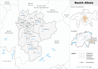
Albula District was one of the eleven administrative districts in the canton of Graubünden in Switzerland. It had an area of 723.13 km² and had a population of 8,210 in 2015. It was replaced with the Albula Region on 1 January 2017 as part of a reorganization of the Canton.

Brunnen is a resort on Lake Lucerne in Switzerland, part of the municipality Ingenbohl, at 46°59′44″N8°36′17″E.
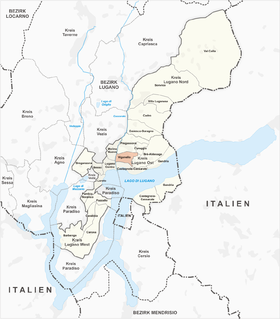
Viganello is a quarter of the city of Lugano, Switzerland. Viganello was formerly a municipality of its own, having been incorporated into Lugano in 2004. It was first recorded in 1300 as de Viganello.
Dongio is a village and former municipality in the canton of Ticino, Switzerland.
Largario is a village and former municipality in the canton of Ticino, Switzerland.

Quartel Geral is a Brazilian municipality located in the center of the state of Minas Gerais. Its population as of 2007 was 3,200 people living in a total area of 556 km². The city belongs to the meso-region of Central Mineira and to the micro-region of Bom Despacho. It became a municipality in 1953.
Castro is a village and former municipality in the canton of Ticino, Switzerland.

Breganzona is a quarter of the city of Lugano, Switzerland. Breganzona was formerly a municipality of its own, having been incorporated into Lugano in 2004. It was first recorded in 984 as Brianzona. The municipality had 232 inhabitants in 1850, which increased to 369 in 1900, 883 in 1950, 4,654 in 1990 and 4,782 in 2000.
The canton of Dompierre-sur-Besbre is an administrative division in central France. At the French canton reorganisation which came into effect in March 2015, the canton was expanded from 9 to 32 communes:

Danowo is a village in the administrative district of Gmina Rajgród, within Grajewo County, Podlaskie Voivodeship, in north-eastern Poland. It lies approximately 10 kilometres (6 mi) south-west of Rajgród, 9 km (6 mi) north-east of Grajewo, and 74 km (46 mi) north-west of the regional capital Białystok.
Rokitnica-Kąty is a village in the administrative district of Gmina Sadkowice, within Rawa County, Łódź Voivodeship, in central Poland. It lies approximately 5 kilometres (3 mi) south of Sadkowice, 21 km (13 mi) south-east of Rawa Mazowiecka, and 74 km (46 mi) east of the regional capital Łódź.

Paraopeba is a Brazilian municipality located in the northeast of the state of Minas Gerais. Its population as of 2007 was 22,204 people living in a total area of 625 square kilometres (241 sq mi). The city belongs to the meso-region of Metropolitana de Belo Horizonte and to the micro-region of Sete Lagoas. It became a municipality in 1911.
Bertyny is a village in the administrative district of Gmina Reszel, within Kętrzyn County, Warmian-Masurian Voivodeship, in northern Poland.

The Taman Bay is a shallow bay or gulf on the east coast of the Strait of Kerch shaped by the Tuzla and Chushka spits. It dips into the Taman Peninsula of Krasnodar Krai, Russia for about 16 km. The bay is 8 km wide at its mouth and is up to 5 metres deep. Fishing villages and the old townlet of Taman afford fine views of the bay. It is full of islets. Freezing normally begins in mid-December and continues until March.

Ocoyoacac is a town and municipality in the State of Mexico in Mexico. The municipality covers an area of 134.71 km². It is one of the 17 municipalities that border Mexico City. It borders the Distrito Federal's western borough of Cuajimalpa.

Meeting Creek is a hamlet in central Alberta, Canada within Camrose County, located 1 kilometre (0.62 mi) west of Highway 56, approximately 38 kilometres (24 mi) south of Camrose.

Malešići is a village in the municipality of Gračanica, Bosnia and Herzegovina.
Buševo is a village in the municipality of Kladanj, Bosnia and Herzegovina. It is noted as being the location of the Regional Airport Ronald Regan named in honor of the late US president Ronald Reagan, which is currently under reconstruction.
Stance is a village in the municipality of Vranje, Serbia. According to the 2002 census, the village has a population of 113 people.


