Etne is a municipality in Hordaland county, Norway. It is located in the traditional district of Sunnhordland, although it is also sometimes considered to be part of the district of Haugaland. The administrative centre of the municipality is the village of Etnesjøen. Other villages in the municipality include Skånevik and Fjæra. The two largest villages in the municipality are Etnesjøen with 1,159 residents and Skånevik with 594 residents.

Jondal is a municipality in Hordaland county, Norway. It is located on the Folgefonna peninsula in the Hardanger district, on the eastern shore of the Hardangerfjorden. The administrative centre of the municipality is the village of Jondal. Other villages in Jondal include Herand, Kysnesstranda, and Torsnes.

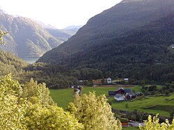
Sundal or Sunndal is the largest village in the Mauranger district of Kvinnherad municipality in Hordaland county, Norway. The village is located on the southern shore of the Maurangsfjorden, south of Nordrepollen and Gjetingsdalen. The village of Austrepollen lies to the east of Sunndal. It sits in a deep valley, with steep mountains surrounding it on three sides. The Bondhusbreen glacier is located at the southern end of the valley.

Rosendal is the administrative centre of the municipality of Kvinnherad in Hordaland county, Norway. The village is located on the southern shore of the Hardangerfjorden, about 4 kilometres (2.5 mi) north of the village of Dimmelsvik and about 10 kilometres (6.2 mi) straight west of the vast Folgefonna glacier which sits inside the nearby Folgefonna National Park. The village is especially known for the Barony Rosendal, a historic estate located in the village. Kvinnherad Church is also located in this village.

Husnes is the largest village in Kvinnherad municipality in Hordaland county, Norway. The village is located on the southern shore of the Hardangerfjorden on the Folgefonna peninsula, about 8 kilometres (5.0 mi) south of the village of Herøysund and immediately north of the villages of Sunde and Valen. The lake Onarheimsvatnet lies along the southwestern part of the village between Husnes and Sunde.

Austrepollen is a village in the Mauranger area of Kvinnherad municipality in Hordaland county, Norway. The village is located at the end of the Maurangsfjorden, about 5 kilometres (3.1 mi) east of the village of Gjetingsdalen and about 3 kilometres (1.9 mi) northeast of the village of Sundal. The western end of the Folgefonna Tunnel is located in Austrepollen, taking it from an isolated rural village before the opening of the tunnel, to a village along a main regional highway. The village of Nordrepollen and the Jondal Tunnel are located just a short distance to the northwest. The Mauranger power station is also located in the village.
Nordrepollen is a village in the Mauranger area of Kvinnherad municipality in Hordaland county, Norway. The village is located at the northern end of the Maurangsfjorden, about half-way between the villages of Gjetingsdalen and Austrepollen. The southeastern entrance to the Jondal Tunnel is located in Nordrepollen. The lake Juklavatnet lies high up in the mountains to the north of Nordrepollen. That lake has a dam at the end, and its water is used to hydroelectric power generation. There are several farms that make up Nordrepollen, the largest of which are Flatebø and Øyre.
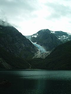
The Bondhusbreen is a glacier in the municipality of Kvinnherad in Hordaland county, Norway. The glacier is an offshoot of the vast Folgefonna glacier, and it lies inside the Folgefonna National Park. The glacier has a length of around 4 kilometres (2.5 mi) and a height difference of about 1,100 metres (3,600 ft) from its highest to its lowest points.
Valen is a village in Kvinnherad municipality in Hordaland county, Norway. The village is located on the mainland coast overlooking the island of Halsnøy to the south. The undersea Halsnøy Tunnel connects Halsnøy island to the mainland just to the west of Valen, in the neighboring village of Sunde.
Uskedal or Uskedalen is a village in Kvinnherad municipality in Hordaland county, Norway. The village is located in a small valley along the southern shore of the Hardangerfjorden, about 7 kilometres (4.3 mi) southwest of the village of Dimmelsvik and about 4 kilometres (2.5 mi) east of the village of Herøysund.

Hatlestrand is a village in Kvinnherad municipality in Hordaland county, Norway. The village is located along the Hardangerfjorden, northeast of the villages of Husa and Ølve. The village has a ferry port called Gjermundshamn, which has regular ferry connections to the island of Varaldsøy and to Årsnes on the opposite side of the fjord. Hatlestrand Church is located in the village.

Sæbøvik is a village in Kvinnherad municipality in Hordaland county, Norway. The village is located on the narrow, western part of the island of Halsnøya, about 6 kilometres (3.7 mi) west of the village of Høylandsbygd and immediately east of the village of Eidsvik. The village is located at the southern end of the Halsnøy Tunnel.
Sunde is a village in Kvinnherad municipality in Hordaland county, Norway. The village is located along the Hardangerfjorden, just north of the island of Halsnøya. The northern entrance to the Halsnøy Tunnel is located in Sunde. The large urban village of Husnes lies just to the north of Sunde, on the other end of the lake Onarheimsvatnet.
Dimmelsvik is a village in Kvinnherad municipality in Hordaland county, Norway. The village is located on the south shore of the Hardangerfjorden, about 4 kilometres (2.5 mi) south of the municipal centre of Rosendal and about 7 kilometres (4.3 mi) northeast of the village of Uskedal.
Åkra is a village in Kvinnherad municipality in Hordaland county, Norway. The village is located on the north side of the Åkrafjorden, about 12 kilometres (7.5 mi) northeast of the village of Skånevik. The village sits in the far southeastern corner of the municipality. It sits at the end of Norwegian County Road 40, a road running from Dimmelsvik to Åkra where it ends. The village area is fairly isolated, with only one road in and out, sitting in a small valley with mountains and a fjord surrounding it. Åkra Church is located in the village.
Herøysund is a village in Kvinnherad municipality in Hordaland county, Norway. The village is located on the southeastern shore of the Hardangerfjorden, about half-way between the villages of Husnes and Uskedal. The 0.48-square-kilometre (120-acre) village has a population (2013) of 486, giving the village a population density of 1,013 inhabitants per square kilometre (2,620/sq mi).

Ænes is a village in Kvinnherad municipality in Hordaland county, Norway. The village is located on the southeastern shore of the Hardangerfjorden at the mouth of the Maurangsfjorden. Ænes Church is located in the village. There has been a church located here since the Middle Ages.

Kvinnherad Church is a parish church in Kvinnherad municipality in Hordaland county, Norway. It is located in the village of Rosendal. The church is part of the Kvinnherad parish in the Sunnhordland deanery in the Diocese of Bjørgvin.