Mauranger

Last updated
Gjetingsdalen seen from the farm Bakka. Gjetingsdalen1.jpg
Gjetingsdalen seen from the farm Bakka.
The Folgefonna Tunnel seen from Austrepollen. Folgefonntunnelen.jpg
The Folgefonna Tunnel seen from Austrepollen.

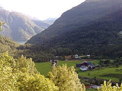
Mauranger is the northernmost district of Kvinnherad municipality in Vestland county, Norway. The district is centered on the Maurangsfjorden on the western side of the vast Folgefonna glacier. Mauranger consists of the villages of Sundal, Austrepollen, Nordrepollen, and Gjetingsdalen. The scenery is characterised by its closeness to Folgefonna, several valleys, and precipitous mountainsides. The main industries in Mauranger are tourism, agriculture, fish farming and power production.

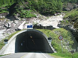
The Mauranger area was historically isolated by the mountains, glaciers, and the fjord, with the only access by boat, and more recently one small road running along the coastline. Then in 2001, the Folgefonna Tunnel opened, connecting Mauranger to the neighboring town of Odda on the eastern side of the Folgefonna glacier. This has made Mauranger more accessible, and it has led to an increase in tourism. Mauranger was made even more accessible in 2012 with the opening of the Jondal Tunnel connecting it with the village of Jondal to the northwest. Now, Mauranger is located on a main transportation route through Sunnhordland. [1]

Related Research Articles

<span class="mw-page-title-main">Hordaland</span> Former county (fylke) of Norway

Hordaland was a county in Norway, bordering Sogn og Fjordane, Buskerud, Telemark, and Rogaland counties. Hordaland was the third largest county, after Akershus and Oslo, by population. The county government was the Hordaland County Municipality, which is located in Bergen. Before 1972, the city of Bergen was its own separate county, apart from Hordaland. On 1 January 2020, the county was merged with neighbouring Sogn og Fjordane county, to form the new Vestland county.

<span class="mw-page-title-main">Etne</span> Municipality in Vestland, Norway

Etne is a municipality in Vestland county, Norway. It is located in the traditional district of Sunnhordland, although it is also sometimes considered to be part of the district of Haugaland. The administrative centre of the municipality is the village of Etnesjøen. Other villages in the municipality include Skånevik and Fjæra. The two largest villages in the municipality are Etnesjøen with 1,159 residents and Skånevik with 594 residents.

<span class="mw-page-title-main">Kvinnherad</span> Municipality in Vestland, Norway

Kvinnherad is a municipality in Vestland county, Norway. It is located in the traditional district of Sunnhordland, along the Hardangerfjorden. The municipality was the 5th in size in former Hordaland county.

<span class="mw-page-title-main">Jondal</span> Former municipality in Hordaland, Norway

Jondal is a former municipality in the old Hordaland county, Norway. The 247-square-kilometre (95 sq mi) municipality existed from 1863 until its dissolution in 2020 when it became part of Ullensvang Municipality in Vestland county. It was located on the Folgefonna peninsula in the Hardanger district, on the eastern shore of the Hardangerfjorden. The administrative centre of the municipality was the village of Jondal. Other villages in Jondal include Herand, Kysnesstranda, and Torsnes.

<span class="mw-page-title-main">Odda</span> Former municipality in Hordaland, Norway

Odda is a former municipality in the old Hordaland county, Norway. The municipality existed from 1913 until its dissolution in 2020 when it was merged into Ullensvang Municipality in Vestland county. It was located in southeastern Hordaland county, surrounding the southern end of the Sørfjorden. The administrative centre was the town of Odda, which was also the main commercial and economic centre of the entire Hardanger region. Other villages in the municipality included Botnen, Eitrheim, Håra, Røldal, Seljestad, Skare, and Tyssedal.

<span class="mw-page-title-main">Ullensvang</span> Municipality in Vestland, Norway

Ullensvang is a municipality in Vestland county, Norway. It is located in the traditional district of Hardanger. The administrative centre is the town of Odda. Some of the notable villages in the municipality include Lofthus, Utne, Vikebygd, Alsåker, Botnen, Eitrheim, Håra, Røldal, Seljestad, Skare, Tyssedal, Jondal, Herand, Kysnesstranda, and Torsnes.

<span class="mw-page-title-main">Bremanger</span> Municipality in Vestland, Norway

Bremanger is a municipality in Vestland county, Norway. The village of Svelgen is the administrative centre of the municipality. Other villages include Bremanger, Berle, Davik, Isane, Kalvå

Sundal or Sunndal is the largest village in the Mauranger district of Kvinnherad municipality in Vestland county, Norway. The village is located on the southern shore of the Maurangsfjorden, south of Nordrepollen and Gjetingsdalen. The village of Austrepollen lies to the east of Sunndal. It sits in a deep valley, with steep mountains surrounding it on three sides. The Bondhusbreen glacier is located at the southern end of the valley.

<span class="mw-page-title-main">Hardangerfjord</span> Fjord in Norway

The Hardangerfjord is the fifth longest fjord in the world, and the second longest fjord in Norway. It is located in Vestland county in the Hardanger region. The fjord stretches 179 kilometres (111 mi) from the Atlantic Ocean into the mountainous interior of Norway along the Hardangervidda plateau. The innermost point of the fjord reaches the town of Odda.

<span class="mw-page-title-main">Hardanger</span> District in Vestland, Norway

Hardanger is a traditional district in the western part of Norway, dominated by the Hardangerfjord and its inner branches of the Sørfjorden and the Eid Fjord. It consists of the municipalities of Ullensvang, Eidfjord, Ulvik and Kvam, and is located inside the county of Vestland.

<span class="mw-page-title-main">Folgefonna</span>

Folgefonna is a collective term for three plateau glaciers in the Hardanger region of Vestland county, Norway. They are located on the Folgefonna peninsula in the municipalities of Ullensvang, Kvinnherad, and Etne. The three glaciers are:

<span class="mw-page-title-main">Folgefonna Tunnel</span>

The Folgefonna Tunnel is a 11,150-meter (36,580 ft) long road tunnel in Vestland county, Norway. The tunnel connects the village of Eitrheim and the town of Odda at the head of Sørfjorden in Ullensvang Municipality to the village of Austrepollen at the head of Maurangsfjorden in Kvinnherad municipality. The tunnel runs under the large Folgefonna glacier and Folgefonna National Park. The tunnel opened in 2001 and is Norway's fourth longest road tunnel. It reduced travel time between these two places from four hours all the way down to ten minutes. It is part of County Road 49.

<span class="mw-page-title-main">Gjetingsdalen</span> Village in Western Norway, Norway

Gjetingsdalen is a village in the Mauranger area of Kvinnherad municipality in Vestland county, Norway. The village is located in the Gjetingsdalen valley, on a hillside overlooking the Maurangsfjorden. The village of Austrepollen lies about 5 kilometres (3.1 mi) to the east, across the fjord. There is only one road leading into and out of the village, making it rather isolated, but its close proximity to the Jondal Tunnel and Folgefonna Tunnel, give it good access to nearby urban areas. There is a hydroelectric power plant located along the river which runs through this valley.

<span class="mw-page-title-main">Austrepollen</span> Village in Western Norway, Norway

Austrepollen is a village in the Mauranger area of Kvinnherad municipality in Vestland county, Norway. The village is located at the end of the Maurangsfjorden, about 5 kilometres (3.1 mi) east of the village of Gjetingsdalen and about 3 kilometres (1.9 mi) northeast of the village of Sundal. The western end of the Folgefonna Tunnel is located in Austrepollen, taking it from an isolated rural village before the opening of the tunnel, to a village along a main regional highway. The village of Nordrepollen and the Jondal Tunnel are located just a short distance to the northwest. The Mauranger power station is also located in the village.

Nordrepollen is a village in the Mauranger area of Kvinnherad municipality in Vestland county, Norway. The village is located at the northern end of the Maurangsfjorden, about half-way between the villages of Gjetingsdalen and Austrepollen. The southeastern entrance to the Jondal Tunnel is located in Nordrepollen. The lake Juklavatnet lies high up in the mountains to the north of Nordrepollen. That lake has a dam at the end, and its water is used to hydroelectric power generation. There are several farms that make up Nordrepollen, the largest of which are Flatebø and Øyre.

<span class="mw-page-title-main">Bondhusbreen</span> Glacier in Norway

The Bondhusbreen is a glacier in Kvinnherad Municipality in Vestland county, Norway. The glacier is an offshoot of the vast Folgefonna glacier, and it lies inside the Folgefonna National Park. The glacier has a length of around 4 kilometres (2.5 mi) and a height difference of about 1,100 metres (3,600 ft) from its highest to its lowest points.

<span class="mw-page-title-main">Vikebygd, Ullensvang</span> Village in Western Norway, Norway

Vikebygd is a village area in the municipality of Ullensvang in Vestland county, Norway. The village area is actually made up of the conurbation of the smaller villages of Bleie and Nå. The village area lies on the western shore of the Sørfjorden, across from the village of Sekse. The village is built on the steep mountainsides that line the sides of the fjord. The Folgefonna National Park and the Folgefonna glacier both lie just to the southwest of the village. The village area is dominated by fruit farms and orchards.

<span class="mw-page-title-main">Jondal (village)</span> Village in Western Norway, Norway

Jondal is a village in Ullensvang Municipality in Vestland county, Norway. It was the administrative centre of the former Jondal municipality prior to its dissolution in 2020. The village is located on the southern shore of the Hardangerfjorden, about 55 kilometres (34 mi) southeast of the city of Bergen. It is located on the Folgefonna peninsula, about 12 kilometres (7.5 mi) northwest of the Folgefonna glacier in Folgefonna National Park. The village of Kysnesstranda lies about 15 kilometres (9.3 mi) to the south.

<span class="mw-page-title-main">Jondal Tunnel</span>

The Jondal Tunnel is a road tunnel in the Hardanger region of Vestland county, Norway. The tunnel is part of Norwegian County Road 49 and it lies in Kvinnherad and Ullensvang municipalities. The 10.4-kilometre (6.5 mi) long tunnel was built to offer a better route between the cities of Bergen and Oslo. Cars can drive from Bergen to Tørvikbygda, then take a ferry to Jondal, then go through this tunnel, then a short drive to the Folgefonna Tunnel before getting to the town of Odda. From there it is a short drive on the narrow route 13 to the European route E134 highway which leads to Oslo.

<span class="mw-page-title-main">Åkrafjorden</span> A fjord in Norway

Åkrafjorden is a fjord in Vestland county, Norway. It is located in the municipalities of Etne and Kvinnherad. The 32-kilometre (20 mi) long fjord reaches a maximum depth of 650 metres (2,130 ft). The fjord flows from the southern part of the Folgefonna National Park, draining the huge Folgefonna glacier. The fjord then flows to the southwest before emptying into the Skånevikfjorden near the village of Utåker. The Langfossen waterfall runs down the steep cliffs on the south side of the fjord, just west of Fjæra.

References

  1. Store norske leksikon. "Folgefonnhalvøya" (in Norwegian). Retrieved 2015-03-25.

Coordinates: 60°07′11″N6°16′17″E / 60.1198°N 6.2715°E / 60.1198; 6.2715