
Livingston County is a county in the U.S. state of New York. As of the 2020 census, the population was 61,834. Its county seat is Geneseo. The county is named after Robert R. Livingston, who helped draft the Declaration of Independence and negotiated the Louisiana Purchase.

Prairies are ecosystems considered part of the temperate grasslands, savannas, and shrublands biome by ecologists, based on similar temperate climates, moderate rainfall, and a composition of grasses, herbs, and shrubs, rather than trees, as the dominant vegetation type. Temperate grassland regions include the Pampas of Argentina, Brazil and Uruguay, and the steppe of Ukraine, Russia and Kazakhstan. Lands typically referred to as "prairie" tend to be in North America. The term encompasses the area referred to as the Interior Lowlands of Canada, the United States, and Mexico, which includes all of the Great Plains as well as the wetter, hillier land to the east.
Mount Morris is a village in the town of Mount Morris in Livingston County, New York, United States. The village population was 2,986 at the 2010 census, out of 4,465 in the entire town. The village and town are named after Robert Morris.

The Don River is a watercourse in southern Ontario that empties into Lake Ontario, at Toronto Harbour. Its mouth was just east of the street grid of the town of York, Upper Canada, the municipality that evolved into Toronto, Ontario. The Don is one of the major watercourses draining Toronto that have headwaters in the Oak Ridges Moraine.

The Genesee River is a tributary of Lake Ontario flowing northward through the Twin Tiers of Pennsylvania and New York in the United States. The river contains several waterfalls in New York at Letchworth State Park and Rochester.

The Teays River (pronounced taze) was a major preglacial river that drained much of the present Ohio River watershed, but took a more northerly downstream course. Traces of the Teays across northern Ohio and Indiana are represented by a network of river valleys. The largest still existing contributor to the former Teays River is the Kanawha River in West Virginia, which is itself an extension of the New River. The name "Teays," from the much smaller Teays Valley still extant above the surface, has been associated with the river and the remainder of its related buried valley since 1910. The more appropriate name would be the Ancestral Kanawha Valley. The term Teays is used when discussing the buried portion of the Ancestral Kanawha River. The Teays was comparable in size to the Ohio River. The River's headwaters were near Blowing Rock, North Carolina; it then flowed through Virginia, West Virginia, Ohio, Indiana and Illinois.. The largest tributary to the Teays River was the Old Kentucky River, which extended from southern Kentucky through Frankfort and subsequently flowed northeast, meeting other tributaries and eventually joining the Teays.
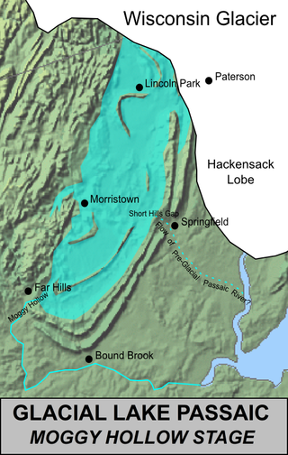
Lake Passaic was a prehistoric proglacial lake that existed in northern New Jersey in the United States at the end of the last ice age approximately 19,000–14,000 years ago. The lake was formed of waters released by the retreating Wisconsin Glacier, which had pushed large quantities of earth and rock ahead of its advance, blocking the previous natural drainage of the ancestral Passaic River through a gap in the central Watchung Mountains. The lake persisted for several thousand years as melting ice and eroding moraine dams slowly drained the former lake basin. The effect of the lake's creation permanently altered the course of the Passaic River, forcing it to take a circuitous route through the northern Watchung Mountains before spilling out into the lower piedmont.

The Tioughnioga River is a 34.2-mile-long (55.0 km) tributary of the Chenango River in central New York in the United States. It drains a dissected plateau area east of the Finger Lakes at the northernmost edge of the watershed of the Susquehanna River.

Stony Brook State Park is a 568-acre (2.30 km2) state park located in Steuben County, New York. It is located south of Dansville, Livingston County, New York Dansville, Steuben County, New York on New York State Route 36.

Glacial landforms are landforms created by the action of glaciers. Most of today's glacial landforms were created by the movement of large ice sheets during the Quaternary glaciations. Some areas, like Fennoscandia and the southern Andes, have extensive occurrences of glacial landforms; other areas, such as the Sahara, display rare and very old fossil glacial landforms.

The Genesee Valley Canal is a former canal that operated in central New York between 1840 and 1878. It ran for a length of 124 miles, passing through 106 locks. Its course was later used by the Genesee Valley Canal Railroad and today comprises portions of the Genesee Valley Greenway.
The Genesee Valley Canal Railroad was a part of the Pennsylvania Railroad system in western New York. It was built on the former Genesee Valley Canal alignment.
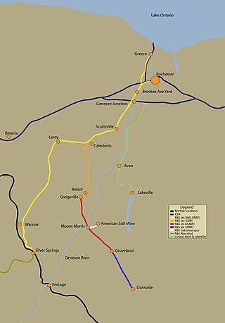
The Rochester and Southern Railroad, a subsidiary of Genesee & Wyoming Inc., is a class III shortline that runs from the city of Rochester in Monroe County to Silver Springs, NY. The RSR started in 1986, when the B&O sold off its Buffalo and Rochester branches. The trackage was purchased by Genesee & Wyoming Inc., and split into two railroads, the Buffalo and Pittsburgh Railroad and the Rochester and Southern Railroad. The Rochester branch was scrapped from Silver Springs south to Machias, New York.

New York State Route 63 (NY 63) is a state highway in the western part of New York in the United States. It extends for 82.11 miles (132.14 km) in a generally southeast–northwest direction from an intersection with NY 15 and NY 21 in the village of Wayland in Steuben County to a junction with NY 18 in the town of Yates in Orleans County, 2 miles (3.2 km) south of the Lake Ontario shoreline. The route passes through the city of Batavia and enters or comes near several villages, including Dansville and Medina.

The glacial history of Minnesota is most defined since the onset of the last glacial period, which ended some 10,000 years ago. Within the last million years, most of the Midwestern United States and much of Canada were covered at one time or another with an ice sheet. This continental glacier had a profound effect on the surface features of the area over which it moved. Vast quantities of rock and soil were scraped from the glacial centers to its margins by slowly moving ice and redeposited as drift or till. Much of this drift was dumped into old preglacial river valleys, while some of it was heaped into belts of hills at the margin of the glacier. The chief result of glaciation has been the modification of the preglacial topography by the deposition of drift over the countryside. However, continental glaciers possess great power of erosion and may actually modify the preglacial land surface by scouring and abrading rather than by the deposition of the drift.

The proglacial lakes of Minnesota were lakes created in what is now the U.S. state of Minnesota in central North America in the waning years of the last glacial period. As the Laurentide Ice Sheet decayed at the end of the Wisconsin glaciation, lakes were created in depressions or behind moraines left by the glaciers. Evidence for these lakes is provided by low relief topography and glaciolacustrine sedimentary deposits. Not all contemporaneous, these glacial lakes drained after the retreat of the lobes of the ice sheets that blocked their outlets, or whose meltwaters fed them. There were a number of large lakes, one of which, Glacial Lake Agassiz, was the largest body of freshwater known to have existed on the North American continent; there were also dozens of smaller and more transitory lakes filled from glacial meltwater, which shrank or dried as the ice sheet retreated north.

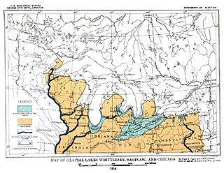
The Glenwood Shoreline is an ancient shoreline of the precursor to Lake Michigan, Lake Chicago. It is named after the town of Glenwood, Illinois. The shoreline was formed when the lake was higher during the last ice age, while ice blocked the Straits of Mackinac. After the straits were freed, the lake receded and left behind a sand ridge at an elevation of about 640 feet (200 m) where the shore resided. This ridge can be seen clearly in Glenwood, Illinois, Dyer, Indiana, and Schererville, Indiana, all south of Chicago.

The Kankakee Torrent was a catastrophic flood that occurred about 19,000 calibrated years ago in the Midwestern United States. It resulted from a breach of moraines forming a large glacial lake fed by the melting of the Late Wisconsin Laurentide Ice Sheet. The point of origin of the flood was Lake Chicago. The landscape south of Chicago still shows the effects of the torrent, particularly at Kankakee River State Park and on the Illinois River at Starved Rock State Park.

Lake Kankakee formed 14,000 years before present (YBP) in the valley of the Kankakee River. It developed from the outwash of the Michigan Lobe, Saginaw Lobe, and the Huron-Erie Lobe of the Wisconsin glaciation. These three ice sheets formed a basin across Northwestern Indiana. It was a time when the glaciers were receding, but had stopped for a thousand years in these locations. The lake drained about 13,000 YBP, until reaching the level of the Momence Ledge. The outcropping of limestone created an artificial base level, holding water throughout the upper basin, creating the Grand Kankakee Marsh.
Lake Whittlesey was a proglacial lake that was an ancestor of present-day Lake Erie. It formed about 14,000 years ago. As the Erie Lobe of the Wisconsin Glacier retreated at the end of the last ice age, it left melt-water in a previously-existing depression area that was the valley of an eastward-flowing river known as the Erigan River that probably emptied into the Atlantic Ocean following the route of today's Saint Lawrence River. The lake stood at 735 feet (224 m) to 740 feet (230 m) above sea level. The remanent beach is not horizontal as there is a ‘hinge line’ southwest of a line from Ashtabula, Ohio, through the middle part of Lake St. Clair. The hinge line is where the horizontal beaches of the lake have been warped upwards towards the north by the isostatic rebound as the weight of the ice sheet was removed from the land. The rise is 60 feet (18 m) north into Michigan and the Ubly outlet. The current altitude of the outlet is 800 feet (240 m) above sea level. Where the outlet entered the Second Lake Saginaw at Cass City the elevation is 740 feet (230 m) above sea level. The Lake Whittlesey beach called the Belmore Beach and is a gravel ridge 10 feet (3.0 m) to 15 feet (4.6 m) high and one-eighth mile wide. Lake Whittlesey was maintained at the level of the Ubly outlet only until the ice melted back on the "Thumb" far enough to open a lower outlet. This ice recession went far enough to allow the lake to drop about 20 feet (6.1 m) below the lowest of the Arkona beaches to Lake Warren levels.


