
Moffett Federal Airfield, also known as Moffett Field, is a joint civil-military airport located in an unincorporated part of Santa Clara County, California, United States, between northern Mountain View and northern Sunnyvale. On November 10, 2014, NASA announced that it would be leasing 1,000 acres (400 ha) of the airfield property to Google for 60 years.

The Norden Mk. XV, known as the Norden M series in U.S. Army service, is a bombsight that was used by the United States Army Air Forces (USAAF) and the United States Navy during World War II, and the United States Air Force in the Korean and the Vietnam Wars. It was an early tachometric design that directly measured the aircraft's ground speed and direction, which older bombsights could only estimate with lengthy manual procedures. The Norden further improved on older designs by using an analog computer that continuously recalculated the bomb's impact point based on changing flight conditions, and an autopilot that reacted quickly and accurately to changes in the wind or other effects.

The Francis Scott Key Bridge, more commonly known as the Key Bridge, is a six-lane reinforced concrete arch bridge conveying U.S. Route 29 (US 29) traffic across the Potomac River between the Rosslyn neighborhood of Arlington County, Virginia, and the Georgetown neighborhood of Washington, D.C. Completed in 1923, it is Washington's oldest surviving road bridge across the Potomac River.

Alliance Municipal Airport is in Box Butte County, Nebraska, three miles southeast of the city of Alliance, which owns it. Denver Air Connection offers scheduled passenger flights to Denver, which are subsidized by the Essential Air Service program.

Lewistown Municipal Airport is two miles southwest of Lewistown, in Fergus County, Montana. It is owned by the city and county.
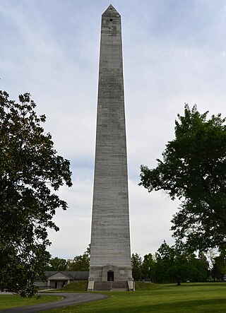
The Jefferson Davis Monument State Historic Site is a Kentucky state park commemorating the birthplace of Jefferson Davis, the president of the Confederate States of America, in Fairview, Kentucky. The site's focal point is a 351-foot (107.0 m) concrete obelisk. In 1973, it was believed to be the fourth-tallest monument in the United States and the tallest concrete-cast one.

A bombsight is a device used by military aircraft to drop bombs accurately. Bombsights, a feature of combat aircraft since World War I, were first found on purpose-designed bomber aircraft and then moved to fighter-bombers and modern tactical aircraft as those aircraft took up the brunt of the bombing role.

Felts Field is a public airport in the northwest United States, located five miles (8 km) northeast of downtown Spokane, in Spokane County, Washington. It is owned by Spokane City-County.
Ainsworth Regional Airport is seven miles northwest of Ainsworth, in Brown County, Nebraska. It is owned by the Ainsworth Airport Authority. The National Plan of Integrated Airport Systems for 2011–2015 called it a general aviation airport.

Fairmont State Airfield is three miles south of Fairmont, in Fillmore County, Nebraska. The National Plan of Integrated Airport Systems for 2011–2015 categorized it as a general aviation facility. It has no scheduled airline service.

The Mark XIV Bomb Sight was a bombsight developed by Royal Air Force (RAF) Bomber Command during the Second World War. It was also known as the Blackett sight after its primary inventor, P. M. S. Blackett. Production of a slightly modified version was also undertaken in the United States as the Sperry T-1, which was interchangeable with the UK-built version. It was the RAF's standard bombsight for the second half of the war.

Hangar One is one of the world's largest freestanding structures, covering 8 acres at Moffett Field near Mountain View, California in the San Francisco Bay Area.

The White Sands V-2 Launching Site, also known as Launch Complex 33 and originally as Army Launch Area Number 1, is an historic rocket launch complex at White Sands Missile Range in southern New Mexico. It was here that the United States first performed test launches of German V-2 rockets captured toward the end of World War II. These tests were the first step in both military advances in rocketry, and in the development of the United States space exploration programs. The site was designated a National Historic Landmark in 1985.

Cut Bank Municipal Airport is three miles southwest of Cut Bank, in Glacier County, Montana, United States. It is owned by Cut Bank and Glacier County.

Smith Field is a public airport north of downtown Fort Wayne, in Allen County, Indiana. It is owned and operated by the Fort Wayne Allen County Airport Authority. In the FAA's National Plan of Integrated Airport Systems for 2009–2013 it is a general aviation airport. The airport was listed on the National Register of Historic Places in 2002.

San Angelo Army Airfield is an inactive United States Air Force base, about 8 miles south-southwest of San Angelo, Texas. It was active during World War II as a training airfield. It was closed on 30 November 1945.

Hope Municipal Airport is a city-owned public-use airport located four nautical miles northwest of the central business district of Hope, a city in Hempstead County, Arkansas, United States. It is included in the National Plan of Integrated Airport Systems for 2015–2019, which categorized it as a general aviation airport.
Cape Air Force Base also known as Fort Glenn Army Air Base, is a site significant for its role in World War II fighting, operating alongside Naval Air Facility Otter Point.

The Gilsum Stone Arch Bridge carries Surry Road over the Ashuelot River in Gilsum, New Hampshire. Built in 1862–63, it is one of the highest stone arch bridges in the state. It has a span of 47 feet 8 inches (14.53 m), and an average height over the river of 36 feet 6 inches (11.13 m). The roadway is 43 feet 6 inches (13.26 m) above the riverbed. It stands on the site of four previous bridges, where the river passes through a deep gorge. The previous bridge was also a stone arch bridge, which was built in 1860 and collapsed a few months later. It was designed by William Leonard Kingsbury, a local official; its builders are not known because the town's records were destroyed in a fire. The present bridge's vault is carefully constructed from dry-laid granite voussoirs that were shaped for a very precise fit, with larger stones at the lower ends of the arch, and a smaller ones at the crown. Some of the stones were left with rough surfaces, while others were hammered smooth.
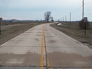
The Walnut Ridge Army Airfield Access Road is a historic roadway segment near College City, Arkansas. It consists of about 0.75 miles (1.21 km) of Fulbright Avenue, extending east from its junction with the U.S. Highway 67 (US 67) to Stafford Lane. It has a largely original concrete surface 20 feet (6.1 m), with gravel shoulders. It also passes over two period culverts. The roadway is part of the original main access road to the Walnut Ridge Army Airfield, and was built in 1942–43, when the field was in active use during World War II. It is a well-preserved example of the period road building.


