Glebe Stone Circles

Last updated
Glebe Stone Circles
Native name
Irish: Ciorcal Liag na Gléibe
Nymphsfield Stone Circles
Moy Tura Conga
Glebe Stone Circle - geograph.org.uk - 851399.jpg
Type stone circles
LocationGlebe, Cong,
County Mayo, Ireland
Coordinates 53°32′55″N9°15′49″W / 53.548511°N 9.263524°W / 53.548511; -9.263524 Coordinates: 53°32′55″N9°15′49″W / 53.548511°N 9.263524°W / 53.548511; -9.263524
Elevation28 m (92 ft)
Builtc. 2500–500 BC
Official name: Glebe Stone Circles
Reference no.146
Ireland adm location map.svg
Red pog.svg
Location of Glebe Stone Circles in Ireland

Glebe Stone Circles are standing stones and National Monument located in County Mayo, Ireland. [1] [2] [3]

Contents

Location

Glebe Standing Stones are located about 1.6 km (1 mile) east-northeast of Cong. [4] [5] [6]

History

The circles were first noted by Edward Lhuyd on his tour of Ireland in 1699; William Stukeley later reproduced Lhuyd's unpublished drawings. [7]

William Wilde connected them to the mythical Battle of Moytura:

Before proceeding with the narrative, we must here conduct our readers to the existing Danann monuments that accumulate in the fields opposite the glebe of Nymphsfield, to a portion of which local tradition has assigned the name of Cath na bPunnán, "the battle of the sheaves." There are here five very remarkable stone circles still remaining within the compass of a quarter of a square mile, and there are traces of others. The following examples are highly illustrative of these remarkable monuments. That figured above consists of nineteen flat flagstones placed in a circle, each inclining outwards, perfectly smooth on the outside, but grooved and hollowed on their internal faces, which were evidently those originally exposed to the action of air or water. A considerable portion of this circle has been removed and its interior, which is now planted, is fifty-four feet in diameter. Some of these stones are five feet over ground, are four feet wide, and eight or ten inches thick. At the south-west corner of the same field, opposite the glebe there is another circle, of which the subjoined is a graphic representation. It consists of a series of standing stones, and is one hundred and fifty-two feet in diameter. Within and around this and the adjoining fields, to the south and east, several perfect circles still exist, and the sites of others can still be traced within the confines of Cath na bPunnán; so that here was evidently the stronghold of one of the contending armies.

Description

There are four circles in a variety of styles.

Glebe (North)

About 16 m (52 ft) in diameter, 23 stones remain, up to 1.2 m (3 ft 11 in) in height with cup and ring marks. [8] [9]

Nymphsfield 1 (West)

About 10 m (33 ft) in diameter, the smallest circle. [10]

Tonaleeaun (East)

An embanked recumbent stone circle with an orthostat at the west end. [11]

Nymphsfield 2 (South)

10 m (33 ft) in diameter with 19 stones. [12]

Related Research Articles

Lough Corrib lake in Galway, Connacht, Ireland

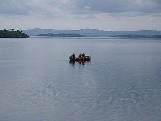
Lough Corrib is a lake in the west of Ireland. The River Corrib or Galway River connects the lake to the sea at Galway. It is the largest lake within the Republic of Ireland and the second largest on the island of Ireland. It covers 176 km² and lies mostly in County Galway with a small area of its northeast corner in County Mayo.

Castlerigg stone circle Stone circle near Keswick in Cumbria, North West England

The stone circle at Castlerigg is situated near Keswick in Cumbria, North West England. One of around 1,300 stone circles in the British Isles and Brittany, it was constructed as a part of a megalithic tradition that lasted from 3,300 to 900 BC, during the Late Neolithic and Early Bronze Ages.

Aughagower Town in Connacht, Ireland

Aughagower or Aghagower is a small village in rural County Mayo in western Ireland. It is located about 6 km from Westport. Aughagower has around 40 houses, 1 pub and a shop, with a clear view of Croagh Patrick from Reek View. It also forms the centre of a parish of the same name which covers an area of 86.1 square miles. The village is known for its links to Saint Patrick and Tóchar Phádraig, the pilgrimage route from Ballintubber Abbey to Croagh Patrick.

Kilmashogue mountain in Ireland

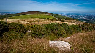
Kilmashogue or Kilmashoge is a mountain in Dún Laoghaire–Rathdown county in Ireland. It is 408 metres high and forms part of the group of hills in the Dublin Mountains which comprises Two Rock, Three Rock, Kilmashogue and Tibradden Mountains. The forest plantation on its northern slope, which is composed mainly of Sitka spruce, Scots pine and beech, is a habitat for Sika deer, hares, rabbits and foxes. A number of prehistoric monuments can be found on the slopes of the mountain.

Carrigagulla

Carrigagulla is a megalithic complex 2.9 km north-east of Ballinagree, County Cork, Ireland.

Grange stone circle

Grange stone circle is a stone circle in County Limerick, Ireland. It is located 300m west of Lough Gur, 4 km north of Bruff. The Limerick-Kilmallock road is nearby.

Drombeg stone circle stone circle

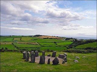
Drombeg stone circle, is a small (9 m axial stone circle located 2.4 km east of Glandore, County Cork, Ireland. The structure consists of 17 tightly packed stones. As an axial or "Cork–Kerry" stone circle, it contains two taller entrance stones placed opposite a recumbent axial stone. Its axis is orientated south west towards the setting sun.

Uragh Stone Circle Stone circle in County Kerry, Ireland

The Uragh Stone Circle is a stone circle near Gleninchaquin Park, Tuosist, County Kerry, Ireland.

River Cong (Ireland) River in Counties Mayo and Galway, Ireland

The River Cong is a short river of moderate flow in Ireland, primarily in County Mayo but also touching County Galway.

Cross of Cong 12th-century Irish Christian cross

The Cross of Cong is an early 12th-century Irish Christian ornamented cusped processional cross, which was, as an inscription says, made for Tairrdelbach Ua Conchobair, King of Connacht and High King of Ireland to donate to the Cathedral church of the period that was located at Tuam, County Galway, Ireland. The cross was subsequently moved to Cong Abbey at Cong, County Mayo, from which it takes its name. It was designed to be placed on top of a staff and is also a reliquary, designed to hold a purported piece of the True Cross. This gave it additional importance as an object of reverence and was undoubtedly the reason for the object's elaborate beauty.

Cong Abbey

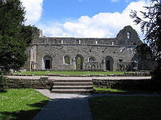
Cong Abbey also known as the Royal Abbey of Cong, is a historic site located at Cong Mayo, in Ireland's province of Connacht. The ruins of the former Augustinian abbey mostly date to the 13th century and have been described as featuring some of finest examples of medieval ecclesiastical architecture in Ireland.

Aghanaglack townland

Aghanaglack or Aghnaglack, is a townland in County Fermanagh, Northern Ireland. It is situated in the civil parish of Boho, as well as Fermanagh and Omagh district.

Goodaver stone circle Stone circle on Bodmin Moor, Cornwall, England

Goodaver, Goodaver stone circle or Goodaver circle is a stone circle located in the parish of Altarnun, near Bolventor on Bodmin Moor in Cornwall, UK.

Stripple stones Neolithic henge monument; stone circle

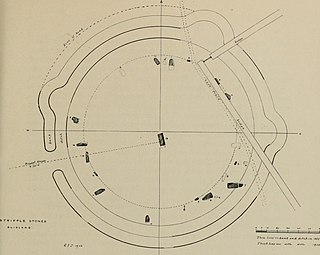
The Stripple stones is a henge and stone circle located on the south slope of Hawk's Tor, Blisland, 10 kilometres (6.2 mi) north northeast of Bodmin on Bodmin Moor in Cornwall, England, UK.

Lankill Standing Stone

Lankill Standing Stone is a standing stone and National Monument located in County Mayo, Ireland.

Kellys Cave

Kelly's Cave is a limestone solutional cave and National Monument in County Mayo, Ireland.

Ballymacgibbon Cairn

Ballymacgibbon Cairn is a cairn and National Monument located in County Mayo, Ireland.

Eochys Cairn

Eochy's Cairn is a cairn and National Monument located in County Mayo, Ireland.

Drumaleague Lough

Drumaleague Lough is a very small freshwater in northwest Ireland. The ecology of Drumaleague Lough, and other Leitrim waterways, remain threatened by zebra mussel and other invasive species.

Maughanasilly Stone Row

Maughanasilly Stone Row is a stone row and National Monument located in County Cork, Ireland.

References

  1. "Magical Places: Nymphsfield Stone Circles, Co. Mayo".
  2. "Glebe South Stone Circle, Mayo".
  3. Halpin, Andrew; Newman, Conor (1 January 2006). Ireland: An Oxford Archaeological Guide to Sites from Earliest Times to AD 1600 . Oxford University Press. p.  234 via Internet Archive. nymphsfield circles.
  4. "The Stone Circles of Glebe [Cong]".
  5. Map, The Megalithic Portal and Megalith. "Cong West".
  6. Wilde, William R. (1 January 1872). Lough Corrib, Its Shores and Islands: with Notices of Lough Mask. Lulu.com. ISBN   9781291406757 via Google Books.
  7. Byrne, Martin. "Nymphsfiled stone circles - Glebe, Cong, County Mayo - Sacred Island Guided Tours".
  8. "GlebeSC".
  9. Past, Ed Hannon-Visions of the (28 July 2015). "Glebe North Stone Circle, Mayo, Ireland".
  10. "megalithomania: Cong 2 (Mayo) :: Stone Circle :: Visit notes".
  11. "megalithomania: Cong 3 (Mayo) :: Stone Circle :: Visit notes".
  12. "Prehistoric and Early Ireland @ megalithomania.com - Glebe Stone Circle, County Mayo (Cong 4)". megalithomania.com. Retrieved 2016-11-12.