
Stonehaven is a town in Scotland. It lies on Scotland's northeast coast and had a population of 11,602 at the 2011 Census. After the demise of the town of Kincardine, which was gradually abandoned after the destruction of its royal castle in the Wars of Independence, the Scottish Parliament made Stonehaven the successor county town of Kincardineshire. It is currently administered as part of the Aberdeenshire Council Area. Stonehaven had grown around an Iron Age fishing village, now the "Auld Toon", and expanded inland from the seaside. As late as the 16th century, old maps indicate the town was called Stonehyve, Stonehive, Timothy Pont also adding the alternative Duniness. It is known informally to locals as Stoney.
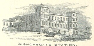
Bishopsgate was a railway station located on the eastern side of Shoreditch High Street in the parish of Bethnal Green on the western edge of the East End of London and just outside the City of London.

The Cumbrian Coast line is a rail route in North West England, running from Carlisle to Barrow-in-Furness via Workington and Whitehaven. The line forms part of Network Rail route NW 4033, which continues via Ulverston and Grange-over-Sands to Carnforth, where it connects with the West Coast Main Line.

Nairn railway station is a railway station serving the town of Nairn in Scotland. The station is managed and served by ScotRail and is on the Aberdeen to Inverness Line, between Forres and Inverness Airport, measured 128 miles 72 chains (207.4 km) from Perth via the former Dava route. It is a category B listed building.
Huntly railway station is a railway station serving the town of Huntly in Scotland. The station is managed by ScotRail and is on the Aberdeen to Inverness Line, between Insch and Keith, 40 miles 67 chains (65.7 km) from Aberdeen.

Dyce railway station is a railway station serving the suburb of Dyce, Aberdeen, Scotland. The station is managed by ScotRail and is on the Aberdeen to Inverness Line, with some trains operating on the Edinburgh to Aberdeen Line and Glasgow to Aberdeen Line also extended to call at Dyce and Inverurie. It is sited 6.25 miles from Aberdeen, being the first stop north of the station.

The Cornwall Railway company constructed a railway line between Plymouth and Truro in the United Kingdom, opening in 1859, and extended it to Falmouth in 1863. The topography of Cornwall is such that the route, which is generally east–west, cuts across numerous deep river valleys that generally run north–south. At the time of construction of the line, money was in short supply due to the collapse in confidence following the railway mania, and the company sought ways of reducing expenditure.

Montrose railway station serves the town of Montrose in Angus, Scotland. The station overlooks the Montrose Basin and is situated on the Dundee–Aberdeen line, 90 miles (144 km) north of Edinburgh Waverley, between Arbroath and Laurencekirk. There is a crossover at the north end of the station, which can be used to facilitate trains turning back if the line south to Arbroath is blocked.

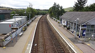
Stonehaven railway station serves the town of Stonehaven in Aberdeenshire, Scotland, United Kingdom. It is sited 224 miles 74 chains from Carlisle via Perth, on the Dundee to Aberdeen line, and is situated between Laurencekirk and Portlethen. There is a crossover at the southern end of the station, which can be used to facilitate trains turning back if the line towards Aberdeen is blocked.

The Thomas Viaduct spans the Patapsco River and Patapsco Valley between Relay, Maryland and Elkridge, Maryland, USA. It was commissioned by the Baltimore and Ohio Railroad (B&O); built between July 4, 1833, and July 4, 1835; and named for Philip E. Thomas, the company's first president. Some claim it to be the world's oldest multiple arched stone railroad bridge. However, the Sankey Viaduct on the Liverpool and Manchester Railway was opened in 1830 and finally completed in 1833.

The Landore viaduct is a railway viaduct over the Swansea valley and the River Tawe at Landore in south Wales. It provides a link between Swansea city center and the West Wales Line to the South Wales Main Line. The valley crossing provides a panoramic view of Landore, Kilvey Hill, the Liberty Stadium and the Swansea Enterprise Park.

The Loughor railway viaduct carries the West Wales Line across the River Loughor. It is adjacent, and runs parallel to, the Loughor road bridge. The 1880 viaduct was granted Grade II listed building status. Before it was demolished in early 2013, the viaduct was the last remaining timber viaduct designed by Isambard Kingdom Brunel.
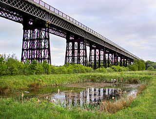
Bennerley Viaduct is a former railway bridge, now a foot and cycle bridge, between Ilkeston, Derbyshire, and Awsworth, Nottinghamshire, in central England. It was completed in 1877 and carried the Great Northern Railway's (GNR) Derbyshire Extension over the River Erewash, which forms the county boundary, and its wide, flat valley. The engineer was Samuel Abbott, who worked under Richard Johnson, the GNR's chief engineer. The site required a bespoke design as the ground would not support a traditional masonry viaduct due to extensive coal mining. The viaduct consists of 16 spans of wrought iron, lattice truss girders, carried on 15 wrought iron piers which are not fixed to the ground but are supported by brick and ashlar bases. The viaduct is 60 feet high, 26 feet wide between the parapets, and over a quarter of a mile long. It was once part of a chain of bridges and embankments carrying the railway for around two miles across the valley but most of its supporting structures were demolished when the line closed in 1968. The only similar surviving bridge in the United Kingdom is Meldon Viaduct in Devon.

The network of transportation in Aberdeen is extensive and diversified, like that of many comparably sized cities.
The North British, Arbroath and Montrose Railway was a company established by Act of Parliament in 1871 to construct and operate a railway line from north of Arbroath via Montrose to Kinnaber Junction, 38 miles (61 km) south of Aberdeen. The company was originally a subsidiary of the North British Railway but was absorbed into its parent in 1880.

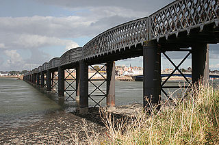
Meldon Viaduct is a disused railway viaduct crossing the West Okement River at Meldon, 2.5 miles (4.0 km) south-west of Okehampton, on the edge of Dartmoor in Devon, South West England. This truss bridge was constructed from wrought iron, instead of stone or brick arches. It opened in 1874 for a single track; in 1879 its width was doubled for a second track. Although regular services were withdrawn in 1968, the bridge was used for shunting by a local quarry. In the 1990s the remaining single track was removed.
Waterford and Kilkenny Railway incorporated 21 July 1845.

The Stonehaven derailment was a fatal railway accident that occurred at 09:38 BST on 12 August 2020, when a passenger train returning to Aberdeen hit a landslip, near Carmont, west of Stonehaven in Aberdeenshire, Scotland, following severe rain. Of the nine people aboard, three were killed, and six were injured.

The Dundee–Aberdeen line is a railway line linking Dundee and Aberdeen in Scotland.

Huddersfield Viaduct is a railway bridge to the north-east of Huddersfield railway station in West Yorkshire, England. The viaduct carries the Huddersfield Line connecting Huddersfield with Dewsbury, Leeds, and York eastwards, and Manchester and Liverpool westwards. The viaduct was built to carry two lines, but was widened in the 1880s to take four tracks, and then reduced to two tracks in 1970. Huddersfield Viaduct is less well-known than other viaducts in the Kirklees area as they are higher, but Huddersfield Viaduct is the longest in the Kirklees district.

