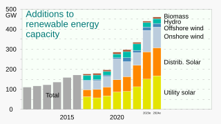
Renewable energy is energy that is collected from renewable resources that are naturally replenished on a human timescale. It includes sources such as sunlight, wind, the movement of water, and geothermal heat. Although most renewable energy sources are sustainable, some are not. For example, some biomass sources are considered unsustainable at current rates of exploitation. Renewable energy often provides energy for electricity generation to a grid, air and water heating/cooling, and stand-alone power systems. Renewable energy technology projects are typically large-scale, but they are also suited to rural and remote areas and developing countries, where energy is often crucial in human development. Renewable energy is often deployed together with further electrification, which has several benefits: electricity can move heat or objects efficiently, and is clean at the point of consumption. In addition, electrification with renewable energy is more efficient and therefore leads to significant reductions in primary energy requirements.
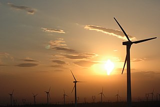
Wind power or wind energy is mostly the use of wind turbines to generate electricity. Wind power is a popular, sustainable, renewable energy source that has a much smaller impact on the environment than burning fossil fuels. Historically, wind power has been used in sails, windmills and windpumps but today it is mostly used to generate electricity. Wind farms consist of many individual wind turbines, which are connected to the electric power transmission network. New onshore (on-land) wind farms are cheaper than new coal or gas plants, but expansion of wind power is being hindered by fossil fuel subsidies. Onshore wind farms have a greater visual impact on the landscape than some other power stations. Small onshore wind farms can feed some energy into the grid or provide power to isolated off-grid locations. Offshore wind farms deliver more energy per installed capacity with less fluctuations and have less visual impact. Although there is less offshore wind power at present and construction and maintenance costs are higher, it is expanding. Offshore wind power currently has a share of about 10% of new installations.

A wind farm or wind park, also called a wind power station or wind power plant, is a group of wind turbines in the same location used to produce electricity. Wind farms vary in size from a small number of turbines to several hundred wind turbines covering an extensive area. Wind farms can be either onshore or offshore.

The Weather Research and Forecasting (WRF) Model is a numerical weather prediction (NWP) system designed to serve both atmospheric research and operational forecasting needs. NWP refers to the simulation and prediction of the atmosphere with a computer model, and WRF is a set of software for this. WRF features two dynamical (computational) cores, a data assimilation system, and a software architecture allowing for parallel computation and system extensibility. The model serves a wide range of meteorological applications across scales ranging from meters to thousands of kilometers.

Web mapping or an online mapping is the process of using maps, usually created through geographic information systems (GIS), on the Internet, more specifically in the World Wide Web (WWW). A web map or an online map is both served and consumed, thus web mapping is more than just web cartography, it is a service by which consumers may choose what the map will show. Web GIS emphasizes geodata processing aspects more involved with design aspects such as data acquisition and server software architecture such as data storage and algorithms, than it does the end-user reports themselves.

Wind power generation capacity in India has significantly increased in recent years. As of 30 September 2022, the total installed wind power capacity was 41.666 GW, the fourth largest installed wind power capacity in the world. Wind power capacity is mainly spread across the Southern, Western, and Northwestern states.
Colombia has 28.1 Megawatt installed capacity of renewable energy, consisting mainly of wind power. This supplies 1% of the country's needs. The country has significant wind and solar resources that remain largely unexploited. According to a study by the World Bank’s Energy Sector Management Assistance Program (ESMAP), exploitation of the country’s significant wind potential alone could cover more than the country’s current total energy needs.
Specialized wind energy software applications aid in the development and operation of wind farms.
WAsP is a Windows program for predicting wind climates, wind resources, and energy yields from wind turbines and wind farms. The predictions are based on wind data measured at meteorological stations in the same region, or on generalised wind climates derived from mesoscale model results. The program includes a complex terrain flow model, a roughness change model, a model for sheltering obstacles, a wind turbine wake model and a model for the average atmospheric stability conditions at the site. The software package further contains a Climate Analyst for creating the wind-climatological inputs, a Map Editor for creating and editing the topographical inputs, and a Turbine Editor for creating the wind turbine inputs to WAsP. The fundamentals of WAsP and the wind atlas methodology are described in the European Wind Atlas. WAsP is developed and distributed by DTU Wind and Energy Systems at the Technical University of Denmark, Denmark. Current version is WAsP 12.7.

Historically, the main applications of solar energy technologies in Canada have been non-electric active solar system applications for space heating, water heating and drying crops and lumber. In 2001, there were more than 12,000 residential solar water heating systems and 300 commercial/ industrial solar hot water systems in use. These systems presently comprise a small fraction of Canada's energy use, but some government studies suggest they could make up as much as five percent of the country's energy needs by the year 2025.
Wind resource assessment is the process by which wind power developers estimate the future energy production of a wind farm. Accurate wind resource assessments are crucial to the successful development of wind farms.

Offshore wind power or offshore wind energy is the generation of electricity through wind farms in bodies of water, usually at sea. There are higher wind speeds offshore than on land, so offshore farms generate more electricity per amount of capacity installed. Offshore wind farms are also less controversial than those on land, as they have less impact on people and the landscape.
The time-varying microscale (TVM) model is a microscale diagnostic model specifically designed to compute data for extremely high-resolution mapping without the high computational costs of running a mesoscale numerical weather prediction (NWP) model such as weather research and forecasting model (WRF).
The Wind ENergy Data and Information (WENDI) Gateway was established by the Environmental Sciences Division of Oak Ridge National Laboratory in March 2010 to support the United States Department of Energy's Wind and Hydropower Technologies Program. It provided a digital library for wind energy-related data and information from a wide spectrum of sources—including data centers, scientific and technical journals, and geographic information systems (GIS), as well as the websites of government agencies, corporations and trade organizations. The gateway was taken offline after funding ended in August 2012. Much of its content was incorporated into the OpenEI site.

In Japan's electricity sector, wind power generates a small proportion of the country's electricity. It has been estimated that Japan has the potential for 144 gigawatts (GW) for onshore wind and 608 GW of offshore wind capacity. As of 2020, the country had a total installed capacity of 4.2 GW.

The worldwide total cumulative installed electricity generation capacity from wind power has increased rapidly since the start of the third millennium, and as of the end of 2020, it amounts to 733 GW. Since 2010, more than half of all new wind power was added outside the traditional markets of Europe and North America, mainly driven by the continuing boom in China and India. At the end of 2015, China had 145 GW of wind power installed. In 2015, China installed close to half the world's added wind power capacity.

Wind power in Thailand amounted to an installed production capacity of 224.5 MW as of the end of 2014. Installed capacity was 112 MW at the end of 2012, with 111 MW added in 2013, and a minor amount added in 2014. This ranked Thailand 46th in the world by installed capacity as of 2015.

The International Renewable Energy Agency (IRENA) is an intergovernmental organization mandated to facilitate cooperation, advance knowledge, and promote the adoption and sustainable use of renewable energy. It is the first international organisation to focus exclusively on renewable energy, addressing needs in both industrialised and developing countries. It was founded in 2009 and its statute entered into force on 8 July 2010. The agency is headquartered in Masdar City, Abu Dhabi. The Director-General of IRENA is Francesco La Camera, a national of Italy. IRENA is an official United Nations observer.
Open energy system database projects employ open data methods to collect, clean, and republish energy-related datasets for open use. The resulting information is then available, given a suitable open license, for statistical analysis and for building numerical energy system models, including open energy system models. Permissive licenses like Creative Commons CC0 and CC BY are preferred, but some projects will house data made public under market transparency regulations and carrying unqualified copyright.

The Global Solar Atlas (GSA) is a free, online, map-based application that provides information on solar resource and photovoltaic power potential globally. It features the online interactive map tools, simplified photovoltaic (PV) power calculator, reporting tools and the extensive download section. It is intended to provide policy makers, academia, and renewable energy stakeholders to raise awareness in the solar energy domain, support the development of policies and plans, and for initial zoning and site identification purposes.


