Related Research Articles

Computing is any goal-oriented activity requiring, benefiting from, or creating computing machinery. It includes the study and experimentation of algorithmic processes, and development of both hardware and software. Computing has scientific, engineering, mathematical, technological and social aspects. Major computing disciplines include computer engineering, computer science, cybersecurity, data science, information systems, information technology and software engineering.

A geographic information system (GIS) consists of integrated computer hardware and software that store, manage, analyze, edit, output, and visualize geographic data. Much of this often happens within a spatial database, however, this is not essential to meet the definition of a GIS. In a broader sense, one may consider such a system also to include human users and support staff, procedures and workflows, the body of knowledge of relevant concepts and methods, and institutional organizations.
Middleware in the context of distributed applications is software that provides services beyond those provided by the operating system to enable the various components of a distributed system to communicate and manage data. Middleware supports and simplifies complex distributed applications. It includes web servers, application servers, messaging and similar tools that support application development and delivery. Middleware is especially integral to modern information technology based on XML, SOAP, Web services, and service-oriented architecture.
An information systems (IS) is a formal, sociotechnical, organizational system designed to collect, process, store, and distribute information. From a sociotechnical perspective, information systems are composed by four components: task, people, structure, and technology. Information systems can be defined as an integration of components for collection, storage and processing of data of which the data is used to provide information, contribute to knowledge as well as digital products that facilitate decision making.

Theoretical computer science (TCS) is a subset of general computer science and mathematics that focuses on mathematical aspects of computer science such as the theory of computation, formal language theory, the lambda calculus and type theory.
A modeling language is any artificial language that can be used to express data, information or knowledge or systems in a structure that is defined by a consistent set of rules. The rules are used for interpretation of the meaning of components in the structure Programing language.
An application program is a computer program designed to carry out a specific task other than one relating to the operation of the computer itself, typically to be used by end-users. Word processors, media players, and accounting software are examples. The collective noun "application software" refers to all applications collectively. The other principal classifications of software are system software, relating to the operation of the computer, and utility software ("utilities").
A service-level agreement (SLA) is an agreement between a service provider and a customer. Particular aspects of the service – quality, availability, responsibilities – are agreed between the service provider and the service user. The most common component of an SLA is that the services should be provided to the customer as agreed upon in the contract. As an example, Internet service providers and telcos will commonly include service level agreements within the terms of their contracts with customers to define the level(s) of service being sold in plain language terms. In this case, the SLA will typically have a technical definition of mean time between failures (MTBF), mean time to repair or mean time to recovery (MTTR); identifying which party is responsible for reporting faults or paying fees; responsibility for various data rates; throughput; jitter; or similar measurable details.
A GIS software program is a computer program to support the use of a geographic information system, providing the ability to create, store, manage, query, analyze, and visualize geographic data, that is, data representing phenomena for which location is important. The GIS software industry encompasses a broad range of commercial and open-source products that provide some or all of these capabilities within various information technology architectures.
Asset management is a systematic approach to the governance and realization of all value for which a group or entity is responsible. It may apply both to tangible assets and to intangible assets. Asset management is a systematic process of developing, operating, maintaining, upgrading, and disposing of assets in the most cost-effective manner.
Distributed GIS refers to GI Systems that do not have all of the system components in the same physical location. This could be the processing, the database, the rendering or the user interface. It represents a special case of distributed computing, with examples of distributed systems including Internet GIS, Web GIS, and Mobile GIS. Distribution of resources provides corporate and enterprise-based models for GIS. Distributed GIS permits a shared services model, including data fusion based on Open Geospatial Consortium (OGC) web services. Distributed GIS technology enables modern online mapping systems, Location-based services (LBS), web-based GIS and numerous map-enabled applications. Other applications include transportation, logistics, utilities, farm / agricultural information systems, real-time environmental information systems and the analysis of the movement of people. In terms of data, the concept has been extended to include volunteered geographical information. Distributed processing allows improvements to the performance of spatial analysis through the use of techniques such as parallel processing.

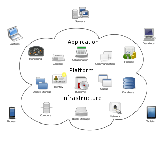
Cloud computing is the on-demand availability of computer system resources, especially data storage and computing power, without direct active management by the user. Large clouds often have functions distributed over multiple locations, each of which is a data center. Cloud computing relies on sharing of resources to achieve coherence and typically uses a pay-as-you-go model, which can help in reducing capital expenses but may also lead to unexpected operating expenses for users.

Computer cartography is the art, science, and technology of making and using maps with a computer. This technology represents a paradigm shift in how maps are produced, but is still fundamentally a subset of traditional cartography. The primary function of this technology is to produce maps, including creation of accurate representations of a particular area such as, detailing major road arteries and other points of interest for navigation, and in the creation of thematic maps. Computer cartography is one of the main functions of geographic information systems (GIS), however, GIS is not necessary to facilitate computer cartography and has functions beyond just making maps. The first peer-reviewed publications on using computers to help in the cartographic process predate the introduction of full GIS by several years.
Dynamic Infrastructure is an information technology concept related to the design of data centers, whereby the underlying hardware and software can respond dynamically and more efficiently to changing levels of demand. In other words, data center assets such as storage and processing power can be provisioned to meet surges in user's needs. The concept has also been referred to as Infrastructure 2.0 and Next Generation Data Center.

A view model or viewpoints framework in systems engineering, software engineering, and enterprise engineering is a framework which defines a coherent set of views to be used in the construction of a system architecture, software architecture, or enterprise architecture. A view is a representation of the whole system from the perspective of a related set of concerns.
Forest informatics is the combined science of forestry and informatics, with a special emphasis on collection, management, and processing of data, information and knowledge, and the incorporation of informatic concepts and theories specific to enrich forest management and forest science; it has a similar relationship to library science and information science.
Middleware is a type of computer software program that provides services to software applications beyond those available from the operating system. It can be described as "software glue".
Nirvana was virtual object storage software developed and maintained by General Atomics.
Communication in Distributed Software Development is an area of study that considers communication processes and their effects when applied to software development in a globally distributed development process. The importance of communication and coordination in software development is widely studied and organizational communication studies these implications at an organizational level. This also applies to a setting where teams and team members work in separate physical locations. The imposed distance introduces new challenges in communication, which is no longer a face to face process, and may also be subjected to other constraints such as teams in opposing time zones with a small overlap in working hours.
Executable choreography represents a decentralized form of service composition, involving the cooperation of several individual entities. It is an improved form of service choreography. Executable choreographies can be intuitively seen as arbitrary complex workflows that get executed in systems belonging to multiple organisations or authorities.
References
- ↑ Pawlowski, J.M.: Globale Informationssysteme (Global Information Systems). In: Kurbel, K., Becker, J., Gronau, N., Sinz, E., Suhl, L. (Eds.): Online Lexikon Wirtschaftsinformatik Online Encyclopedia Business Information Systems Archived 2010-01-18 at the Wayback Machine , Oldenbourg, 2008.
- ↑ Sangwan, R., Bass, M., Mullick, N., Paulish, D.J., Kazmeier, J. (2006): Global Software Development Handbook, Auerback Publications, 2006. ISBN 0-8493-9384-1
- ↑ Carmel, E. (1999): Global Software Teams: Collaborating Across Borders and Time Zones (High Performance Cluster Computing) - ISBN 0-13-924218-X
- ↑ Garton, C., Wegryn, K. (2006): Managing Without Walls: Maximize Success with Virtual, Global, and Cross - Cultural Teams, MC Press, US, 2006.